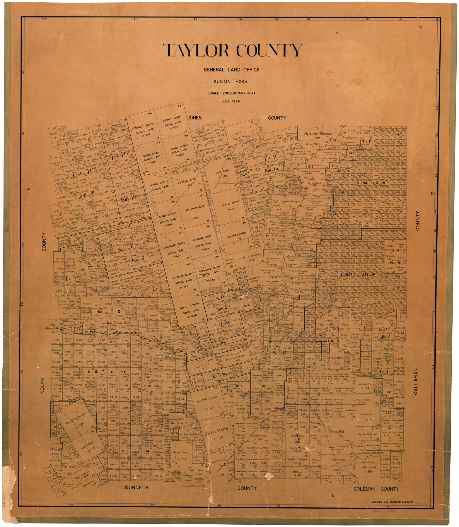
Taylor County
-
Map/Doc
73299
-
Collection
General Map Collection
-
Object Dates
1934 (Creation Date)
-
People and Organizations
Texas General Land Office (Publisher)
W.B. Smith (Draftsman)
W.B. Smith (Compiler)
-
Counties
Taylor
-
Subjects
County
-
Height x Width
44.4 x 38.9 inches
112.8 x 98.8 cm
-
Comments
Hand lettered.
Note on reverse side: "Hung July 17, 1934 by W. B. Smith." -
Features
Tuscola
Fort Gates Road
Bulger Creek
Bradshaw
Bluff Creek
Bluff Creek
Guion
Jim Ned Creek
Moro
Buffalo Gap
Lawn
Shep
Ovalo
A&S
Mulberry Creek
Elm Creek
View
AT&SF
Evans Creek
Blair
Abilene
Tye
T&P
Merkel
Bullwagon Creek
Salt Creek
Bitter Creek
Trent
Part of: General Map Collection
[Right of Way & Track Map, The Texas & Pacific Ry. Co. Main Line]
![64671, [Right of Way & Track Map, The Texas & Pacific Ry. Co. Main Line], General Map Collection](https://historictexasmaps.com/wmedia_w700/maps/64671.tif.jpg)
Print $20.00
- Digital $50.00
[Right of Way & Track Map, The Texas & Pacific Ry. Co. Main Line]
Size 10.8 x 19.0 inches
Map/Doc 64671
Motley County Sketch File 1 (S)

Print $22.00
- Digital $50.00
Motley County Sketch File 1 (S)
1879
Size 9.0 x 14.3 inches
Map/Doc 32139
Colorado River, Buecher State Park

Print $4.00
- Digital $50.00
Colorado River, Buecher State Park
1934
Size 20.8 x 11.6 inches
Map/Doc 65324
Swisher County Sketch File 1

Print $28.00
- Digital $50.00
Swisher County Sketch File 1
1884
Size 13.0 x 8.2 inches
Map/Doc 37566
Flight Mission No. DCL-3C, Frame 156, Kenedy County

Print $20.00
- Digital $50.00
Flight Mission No. DCL-3C, Frame 156, Kenedy County
1943
Size 18.5 x 22.3 inches
Map/Doc 85804
Wharton County

Print $40.00
- Digital $50.00
Wharton County
1946
Size 43.1 x 49.7 inches
Map/Doc 95671
Navarro County Sketch File 22

Print $6.00
- Digital $50.00
Navarro County Sketch File 22
1873
Size 10.0 x 8.0 inches
Map/Doc 32352
Cooke County Working Sketch 7

Print $20.00
- Digital $50.00
Cooke County Working Sketch 7
1939
Size 25.1 x 33.7 inches
Map/Doc 68244
Val Verde County Working Sketch 112

Print $40.00
- Digital $50.00
Val Verde County Working Sketch 112
1990
Size 48.2 x 30.8 inches
Map/Doc 72247
[Galveston, Harrisburg & San Antonio from El Paso-Presidio county boundary to Presidio-Pecos county boundary]
![64717, [Galveston, Harrisburg & San Antonio from El Paso-Presidio county boundary to Presidio-Pecos county boundary], General Map Collection](https://historictexasmaps.com/wmedia_w700/maps/64717.tif.jpg)
Print $40.00
- Digital $50.00
[Galveston, Harrisburg & San Antonio from El Paso-Presidio county boundary to Presidio-Pecos county boundary]
Size 149.3 x 44.4 inches
Map/Doc 64717
Flight Mission No. BRE-2P, Frame 100, Nueces County

Print $20.00
- Digital $50.00
Flight Mission No. BRE-2P, Frame 100, Nueces County
1956
Size 18.5 x 22.3 inches
Map/Doc 86785
Kimble County Working Sketch 4

Print $20.00
- Digital $50.00
Kimble County Working Sketch 4
1913
Size 26.8 x 21.7 inches
Map/Doc 70072
You may also like
United States - Gulf Coast Texas - Northern part of Laguna Madre

Print $20.00
- Digital $50.00
United States - Gulf Coast Texas - Northern part of Laguna Madre
1923
Size 26.7 x 18.2 inches
Map/Doc 72930
Flight Mission No. CRE-2R, Frame 161, Jackson County

Print $20.00
- Digital $50.00
Flight Mission No. CRE-2R, Frame 161, Jackson County
1956
Size 18.5 x 22.1 inches
Map/Doc 85372
Roach Estate Ranch, Gaines County, Texas

Print $20.00
- Digital $50.00
Roach Estate Ranch, Gaines County, Texas
Size 18.0 x 34.6 inches
Map/Doc 92681
Moore County Rolled Sketch 14

Print $20.00
- Digital $50.00
Moore County Rolled Sketch 14
1981
Size 22.6 x 26.6 inches
Map/Doc 6830
Wichita County Sketch File 13a

Print $6.00
- Digital $50.00
Wichita County Sketch File 13a
1881
Size 9.4 x 6.0 inches
Map/Doc 40084
From Citizens of Liberty County for the Creation of a New County (Unnamed), September 7, 1840

Print $20.00
From Citizens of Liberty County for the Creation of a New County (Unnamed), September 7, 1840
2020
Size 25.0 x 21.7 inches
Map/Doc 96390
Limestone County Sketch File 5a

Print $6.00
- Digital $50.00
Limestone County Sketch File 5a
1858
Size 9.4 x 7.3 inches
Map/Doc 30164

Flight Mission No. DQN-5K, Frame 26, Calhoun County

Print $20.00
- Digital $50.00
Flight Mission No. DQN-5K, Frame 26, Calhoun County
1953
Size 18.6 x 22.3 inches
Map/Doc 84377
Irion County Working Sketch 16

Print $20.00
- Digital $50.00
Irion County Working Sketch 16
1973
Size 37.8 x 36.7 inches
Map/Doc 66425
Nueces County Sketch File 59

Print $23.00
- Digital $50.00
Nueces County Sketch File 59
1989
Size 11.2 x 8.6 inches
Map/Doc 32951
Upton County Working Sketch 59

Print $20.00
- Digital $50.00
Upton County Working Sketch 59
1987
Size 21.5 x 34.3 inches
Map/Doc 69556