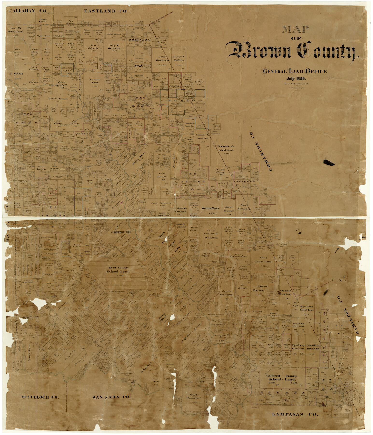
Map of Brown County
-
Map/Doc
3342
-
Collection
General Map Collection
-
Object Dates
7/1886 (Creation Date)
-
People and Organizations
F.G. Blau (Draftsman)
-
Counties
Brown
-
Subjects
County
-
Height x Width
48.9 x 41.6 inches
124.2 x 105.7 cm
-
Features
Clear Creek
Prescott Branch
Bulls Creek
Brown's Creek
Hampton Creek
West Fork of Indian Creek
Indian Creek
Brown's Creek
Pompeo's Creek
Spring Branch of Greenbriar Creek
East Fork of Blanket Creek
West Fork of Blanket Creek
Brownwood
Jim Ned Creek
Elm Creek
Pecan Bayou
Paint Creek
Greenbriar Creek
Part of: General Map Collection
Map of Corpus Christi Bay in Nueces County Showing Subdivision Thereof for Mineral Development

Print $20.00
- Digital $50.00
Map of Corpus Christi Bay in Nueces County Showing Subdivision Thereof for Mineral Development
1940
Size 23.3 x 34.7 inches
Map/Doc 2941
Brewster County Rolled Sketch 110

Print $20.00
- Digital $50.00
Brewster County Rolled Sketch 110
1961
Size 19.7 x 37.7 inches
Map/Doc 5262
Galveston County Aerial Photograph Index Sheet 2

Print $20.00
- Digital $50.00
Galveston County Aerial Photograph Index Sheet 2
1953
Size 21.2 x 19.5 inches
Map/Doc 83693
Liberty County Working Sketch 65

Print $20.00
- Digital $50.00
Liberty County Working Sketch 65
1970
Size 27.6 x 47.3 inches
Map/Doc 70525
Right of Way and Track Map International & Gt. Northern Ry. operated by the International & Gt. Northern Ry. Co., Columbia Branch, Gulf Division

Print $40.00
- Digital $50.00
Right of Way and Track Map International & Gt. Northern Ry. operated by the International & Gt. Northern Ry. Co., Columbia Branch, Gulf Division
1917
Size 25.0 x 56.8 inches
Map/Doc 64599
Randall County Rolled Sketch 9B

Print $20.00
- Digital $50.00
Randall County Rolled Sketch 9B
1985
Size 45.0 x 34.5 inches
Map/Doc 9810
Smith County Rolled Sketch 6A1

Print $40.00
- Digital $50.00
Smith County Rolled Sketch 6A1
Size 49.2 x 38.6 inches
Map/Doc 10704
Terrell County Working Sketch 12

Print $20.00
- Digital $50.00
Terrell County Working Sketch 12
1926
Size 18.3 x 21.0 inches
Map/Doc 62161
Fisher County Working Sketch 6

Print $20.00
- Digital $50.00
Fisher County Working Sketch 6
1929
Size 38.7 x 33.6 inches
Map/Doc 69140
Schleicher County Rolled Sketch 16

Print $20.00
- Digital $50.00
Schleicher County Rolled Sketch 16
Size 27.4 x 29.0 inches
Map/Doc 7758
Cameron County NRC Article 33.136 Sketch 4

Print $94.00
- Digital $50.00
Cameron County NRC Article 33.136 Sketch 4
2007
Size 22.3 x 34.0 inches
Map/Doc 88721

You may also like
Ownership Map Upton Co., Texas

Ownership Map Upton Co., Texas
1951
Size 45.6 x 56.9 inches
Map/Doc 89904
Crockett County

Print $40.00
- Digital $50.00
Crockett County
1882
Size 57.6 x 31.6 inches
Map/Doc 88865
Nuevo Mapa Geographico de la America Septentrional, Perteneciente al Virreynato de Mexico

Print $20.00
- Digital $50.00
Nuevo Mapa Geographico de la America Septentrional, Perteneciente al Virreynato de Mexico
1768
Size 23.1 x 30.3 inches
Map/Doc 93835
Sutton County Working Sketch 61

Print $20.00
- Digital $50.00
Sutton County Working Sketch 61
1959
Size 44.1 x 38.6 inches
Map/Doc 62404
Flight Mission No. DAH-17M, Frame 63, Orange County

Print $20.00
- Digital $50.00
Flight Mission No. DAH-17M, Frame 63, Orange County
1953
Size 18.6 x 22.4 inches
Map/Doc 86897
Runnels County Working Sketch 28

Print $20.00
- Digital $50.00
Runnels County Working Sketch 28
1959
Size 41.9 x 35.2 inches
Map/Doc 63624
McLennan County Sketch File 13a

Print $6.00
- Digital $50.00
McLennan County Sketch File 13a
Size 8.1 x 7.8 inches
Map/Doc 31269
Fort Bend County Boundary File 2a

Print $42.00
- Digital $50.00
Fort Bend County Boundary File 2a
Size 23.7 x 34.3 inches
Map/Doc 53563
[Texas Gulf Coast from Rio Grande to Sabine Lake]
![72688, [Texas Gulf Coast from Rio Grande to Sabine Lake], General Map Collection](https://historictexasmaps.com/wmedia_w700/maps/72688.tif.jpg)
Print $20.00
- Digital $50.00
[Texas Gulf Coast from Rio Grande to Sabine Lake]
Size 27.8 x 18.3 inches
Map/Doc 72688
Bird's Eye View of Bastrop, Bastrop County, Texas

Print $20.00
Bird's Eye View of Bastrop, Bastrop County, Texas
1887
Size 18.8 x 25.7 inches
Map/Doc 89073
Flight Mission No. DQO-1K, Frame 19, Galveston County

Print $20.00
- Digital $50.00
Flight Mission No. DQO-1K, Frame 19, Galveston County
1952
Size 18.9 x 22.6 inches
Map/Doc 84978
Flight Mission No. BRA-9M, Frame 62, Jefferson County

Print $20.00
- Digital $50.00
Flight Mission No. BRA-9M, Frame 62, Jefferson County
1953
Size 18.7 x 22.3 inches
Map/Doc 85645