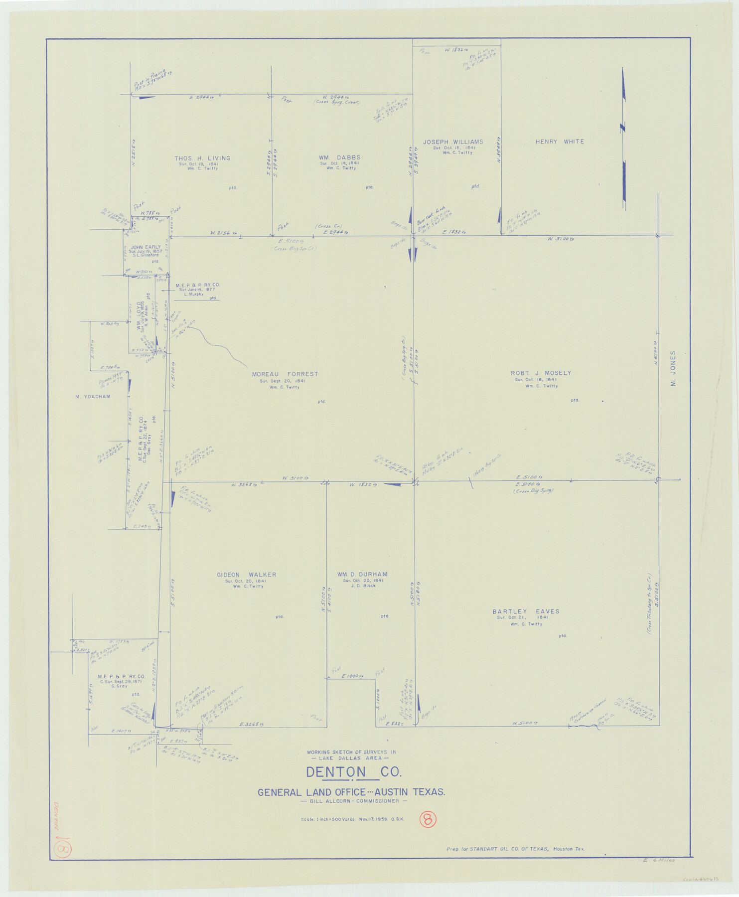
Denton County Working Sketch 8
-
Map/Doc
68613
-
Collection
General Map Collection
-
Object Dates
11/17/1959 (Creation Date)
-
People and Organizations
Otto G. Kurio (Draftsman)
-
Counties
Denton
-
Subjects
Surveying Working Sketch
-
Height x Width
37.4 x 30.8 inches
95.0 x 78.2 cm
-
Scale
1" = 500 varas
Part of: General Map Collection
Frio County Sketch File 5

Print $4.00
- Digital $50.00
Frio County Sketch File 5
1878
Size 7.9 x 11.2 inches
Map/Doc 23116
Yoakum County Sketch File 11

Print $4.00
- Digital $50.00
Yoakum County Sketch File 11
1914
Size 11.3 x 8.9 inches
Map/Doc 40763
[Sketch for Mineral Application 16700 - Pecos River Bed]
![2808, [Sketch for Mineral Application 16700 - Pecos River Bed], General Map Collection](https://historictexasmaps.com/wmedia_w700/maps/2808.tif.jpg)
Print $20.00
- Digital $50.00
[Sketch for Mineral Application 16700 - Pecos River Bed]
1927
Size 19.9 x 30.9 inches
Map/Doc 2808
McMullen County Sketch File 43

Print $10.00
- Digital $50.00
McMullen County Sketch File 43
1942
Size 14.2 x 8.8 inches
Map/Doc 31421
Cottle County Boundary File 1a

Print $40.00
- Digital $50.00
Cottle County Boundary File 1a
Size 34.5 x 17.3 inches
Map/Doc 51955
Flight Mission No. BRA-17M, Frame 11, Jefferson County

Print $20.00
- Digital $50.00
Flight Mission No. BRA-17M, Frame 11, Jefferson County
1953
Size 18.4 x 22.2 inches
Map/Doc 85792
Map of Reeves County

Print $20.00
- Digital $50.00
Map of Reeves County
1892
Size 47.2 x 35.4 inches
Map/Doc 78401
Flight Mission No. BRA-7M, Frame 29, Jefferson County

Print $20.00
- Digital $50.00
Flight Mission No. BRA-7M, Frame 29, Jefferson County
1953
Size 18.5 x 22.3 inches
Map/Doc 85480
Hays County Sketch File 13 and 14

Print $8.00
- Digital $50.00
Hays County Sketch File 13 and 14
1868
Size 12.4 x 8.0 inches
Map/Doc 26220
Flight Mission No. CGI-3N, Frame 137, Cameron County

Print $20.00
- Digital $50.00
Flight Mission No. CGI-3N, Frame 137, Cameron County
1954
Size 18.6 x 22.2 inches
Map/Doc 84610
Texas Official Highway Travel Map

Digital $50.00
Texas Official Highway Travel Map
Size 27.1 x 36.2 inches
Map/Doc 94311
El Paso County Working Sketch 15

Print $40.00
- Digital $50.00
El Paso County Working Sketch 15
1957
Size 23.3 x 127.5 inches
Map/Doc 69037
You may also like
Map showing the line of the True Southern Pacific Railway and the short link necessary for its completion

Print $20.00
- Digital $50.00
Map showing the line of the True Southern Pacific Railway and the short link necessary for its completion
1881
Size 10.5 x 26.7 inches
Map/Doc 93789

Franklin County Sketch File 9

Print $20.00
- Digital $50.00
Franklin County Sketch File 9
Size 13.6 x 23.1 inches
Map/Doc 11515
Johnson County Working Sketch 36

Print $20.00
- Digital $50.00
Johnson County Working Sketch 36
2016
Size 24.1 x 36.1 inches
Map/Doc 94088
Map of a part of Fisher and Miller's Colony - Harvey's District

Print $20.00
- Digital $50.00
Map of a part of Fisher and Miller's Colony - Harvey's District
1856
Size 18.6 x 24.5 inches
Map/Doc 4658
San Patricio County Rolled Sketch 30A

Print $20.00
- Digital $50.00
San Patricio County Rolled Sketch 30A
1941
Size 23.3 x 30.4 inches
Map/Doc 9897
Central Europe designed to accompany Smith's Geography for Schools

Print $20.00
- Digital $50.00
Central Europe designed to accompany Smith's Geography for Schools
1850
Size 12.1 x 9.8 inches
Map/Doc 93895
Stonewall County Sketch File 18-1

Print $8.00
- Digital $50.00
Stonewall County Sketch File 18-1
1905
Size 11.3 x 8.6 inches
Map/Doc 37284
Medina County Rolled Sketch 23

Print $20.00
- Digital $50.00
Medina County Rolled Sketch 23
Size 30.4 x 42.6 inches
Map/Doc 89063
G & H Blocks, Gaines County, Texas Resurvey

Print $40.00
- Digital $50.00
G & H Blocks, Gaines County, Texas Resurvey
1915
Size 58.4 x 34.1 inches
Map/Doc 89668
[Blocks 44 and 6T and vicinity]
![91490, [Blocks 44 and 6T and vicinity], Twichell Survey Records](https://historictexasmaps.com/wmedia_w700/maps/91490-1.tif.jpg)
Print $20.00
- Digital $50.00
[Blocks 44 and 6T and vicinity]
Size 29.4 x 17.4 inches
Map/Doc 91490
Brewster County Rolled Sketch 114

Print $20.00
- Digital $50.00
Brewster County Rolled Sketch 114
1964
Size 11.7 x 18.3 inches
Map/Doc 5276