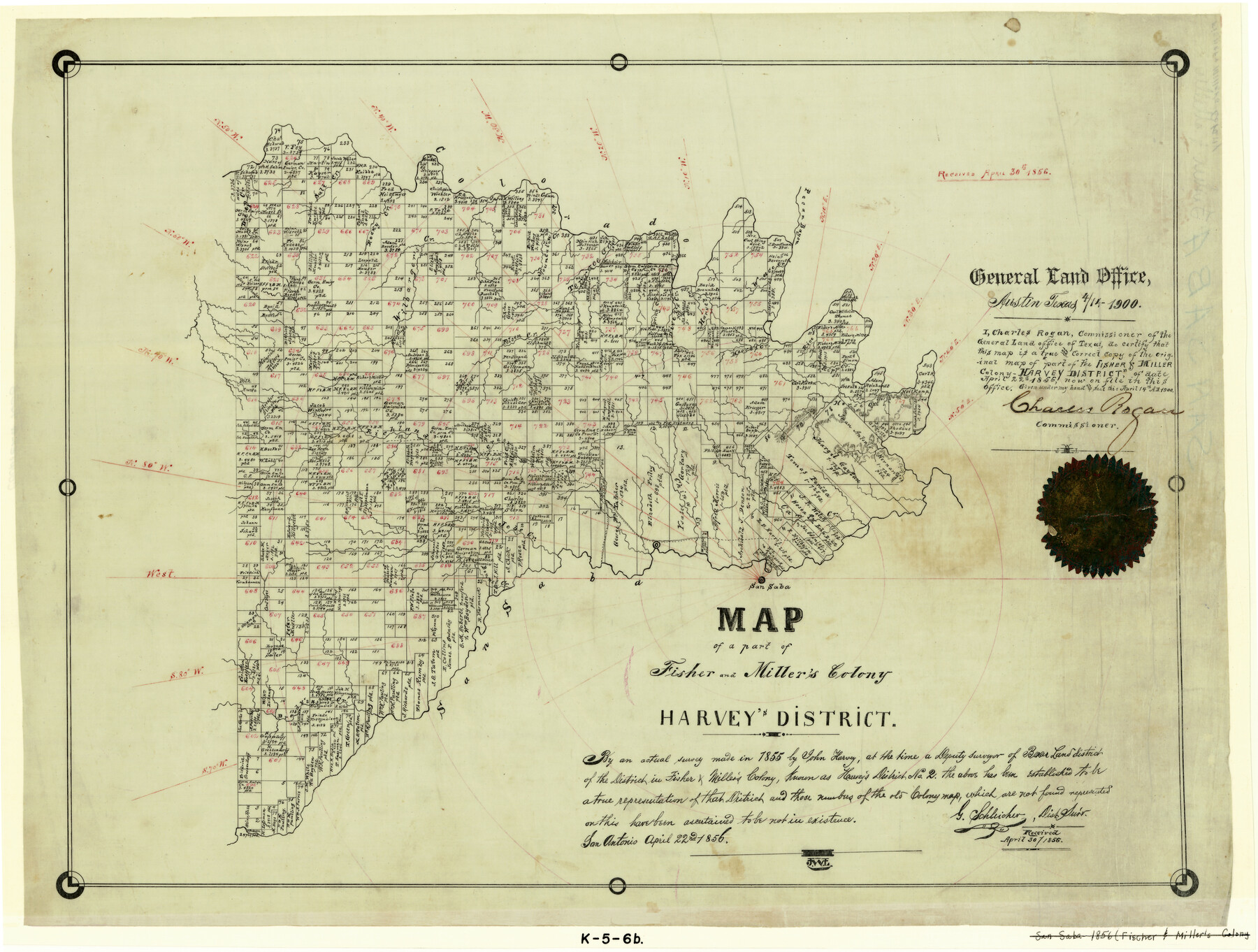
Map of a part of Fisher and Miller's Colony - Harvey's District
K-5-6c
-
Map/Doc
4658
-
Collection
General Map Collection
-
Object Dates
1856 (Creation Date)
4/14/1900 (Tracing Date)
-
People and Organizations
Charles Rogan (GLO Commissioner)
G. Schleicher (Surveyor/Engineer)
-
Counties
San Saba
-
Subjects
Colony
-
Height x Width
18.6 x 24.5 inches
47.2 x 62.2 cm
-
Comments
See map 1972 for original.
Part of: General Map Collection
Military Reconnaissance [showing forts along Rio Grande near Matamoros]
![72910, Military Reconnaissance [showing forts along Rio Grande near Matamoros], General Map Collection](https://historictexasmaps.com/wmedia_w700/maps/72910.tif.jpg)
Print $20.00
- Digital $50.00
Military Reconnaissance [showing forts along Rio Grande near Matamoros]
1846
Size 18.4 x 26.7 inches
Map/Doc 72910
Terry County Sketch File 13

Print $20.00
- Digital $50.00
Terry County Sketch File 13
Size 43.2 x 10.2 inches
Map/Doc 10397
Flight Mission No. CRK-7P, Frame 79, Refugio County

Print $20.00
- Digital $50.00
Flight Mission No. CRK-7P, Frame 79, Refugio County
1956
Size 18.2 x 22.1 inches
Map/Doc 86950
Duval County Sketch File 74

Print $42.00
- Digital $50.00
Duval County Sketch File 74
Size 10.1 x 8.8 inches
Map/Doc 21465
Houston County Working Sketch 14

Print $20.00
- Digital $50.00
Houston County Working Sketch 14
1957
Size 35.1 x 24.0 inches
Map/Doc 66244
North end of Brazos Island

Print $20.00
- Digital $50.00
North end of Brazos Island
Size 26.0 x 18.3 inches
Map/Doc 72915
Bandera County Working Sketch 11

Print $20.00
- Digital $50.00
Bandera County Working Sketch 11
1928
Size 17.8 x 27.4 inches
Map/Doc 67604
Culberson County Rolled Sketch 53

Print $20.00
- Digital $50.00
Culberson County Rolled Sketch 53
1968
Size 36.7 x 47.2 inches
Map/Doc 8756
Freestone County Working Sketch 1

Print $20.00
- Digital $50.00
Freestone County Working Sketch 1
1913
Size 20.2 x 27.2 inches
Map/Doc 69243
Flight Mission No. BRA-17M, Frame 16, Jefferson County

Print $20.00
- Digital $50.00
Flight Mission No. BRA-17M, Frame 16, Jefferson County
1953
Size 18.5 x 22.3 inches
Map/Doc 85797
Polk County Boundary File 70a

Print $40.00
- Digital $50.00
Polk County Boundary File 70a
Size 18.1 x 23.4 inches
Map/Doc 57935
Map of Mason County

Print $20.00
- Digital $50.00
Map of Mason County
1859
Size 28.4 x 22.4 inches
Map/Doc 3838
You may also like
Panola County Rolled Sketch 6

Print $40.00
- Digital $50.00
Panola County Rolled Sketch 6
1956
Size 26.0 x 55.7 inches
Map/Doc 9679
Flight Mission No. DAG-18K, Frame 190, Matagorda County

Print $20.00
- Digital $50.00
Flight Mission No. DAG-18K, Frame 190, Matagorda County
1952
Size 18.6 x 22.3 inches
Map/Doc 86382
Archer County Boundary File 4

Print $54.00
- Digital $50.00
Archer County Boundary File 4
Size 8.9 x 9.7 inches
Map/Doc 50103
La Salle County Sketch File 30

Print $22.00
- Digital $50.00
La Salle County Sketch File 30
1880
Size 12.6 x 8.2 inches
Map/Doc 29565
The Republic County of Goliad. December 29, 1845

Print $20.00
The Republic County of Goliad. December 29, 1845
2020
Size 17.5 x 21.7 inches
Map/Doc 96152
Crockett County Working Sketch 85

Print $40.00
- Digital $50.00
Crockett County Working Sketch 85
1976
Size 23.4 x 54.8 inches
Map/Doc 68418

Flight Mission No. CGI-1N, Frame 220, Cameron County

Print $20.00
- Digital $50.00
Flight Mission No. CGI-1N, Frame 220, Cameron County
1955
Size 18.5 x 22.1 inches
Map/Doc 84529
Brooks County Working Sketch 13

Print $20.00
- Digital $50.00
Brooks County Working Sketch 13
1943
Size 22.4 x 31.9 inches
Map/Doc 67797
Terrell County Sketch File 35

Print $36.00
- Digital $50.00
Terrell County Sketch File 35
1957
Size 32.0 x 37.6 inches
Map/Doc 10389
Midland County Sketch File 3

Print $20.00
- Digital $50.00
Midland County Sketch File 3
1886
Size 18.3 x 25.2 inches
Map/Doc 12081
Pecos County Sketch File 88

Print $6.00
- Digital $50.00
Pecos County Sketch File 88
1934
Size 17.0 x 11.0 inches
Map/Doc 33984