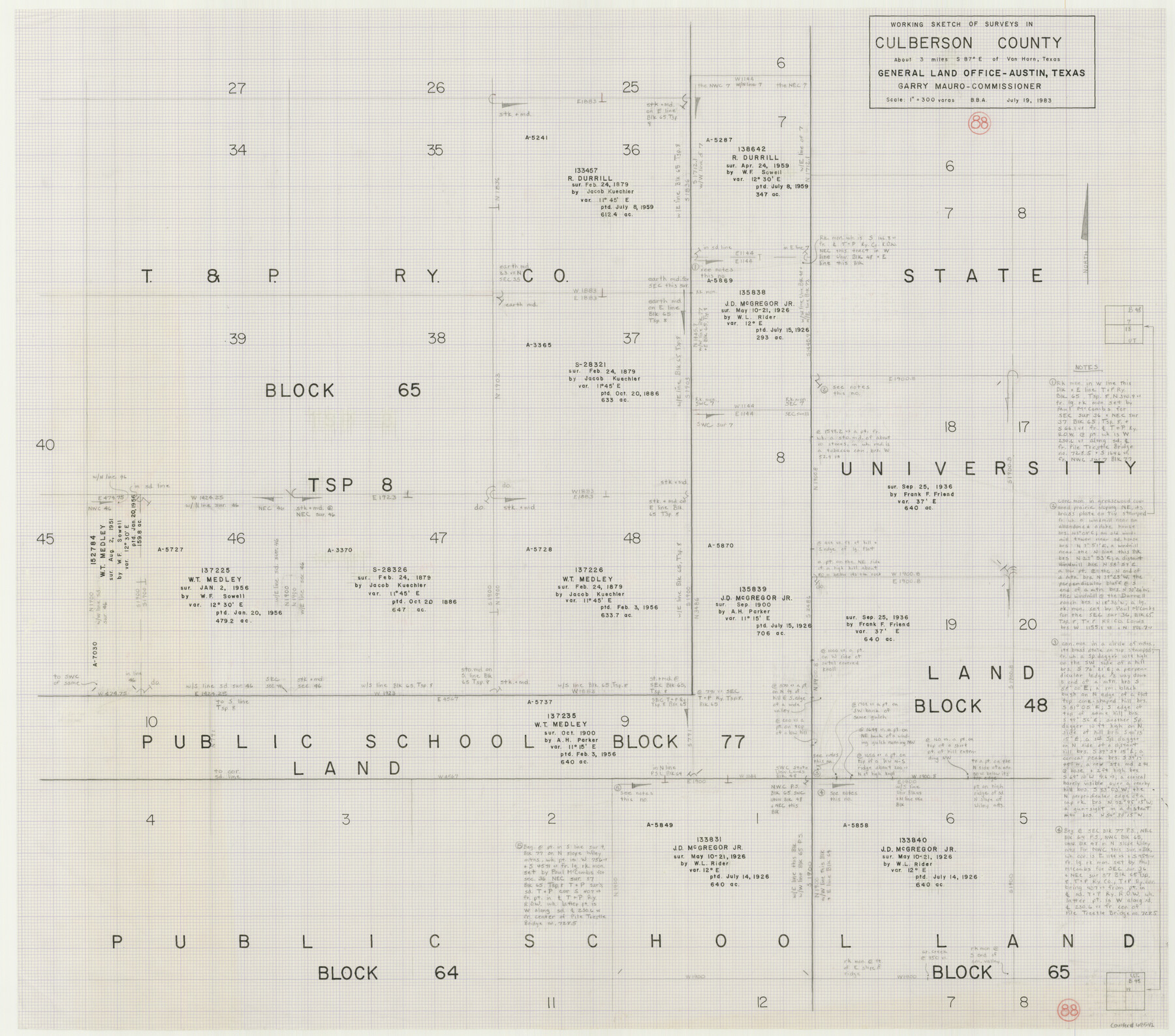
Culberson County Working Sketch 88
-
Map/Doc
68542
-
Collection
General Map Collection
-
Object Dates
7/19/1983 (Creation Date)
-
Counties
Culberson
-
Subjects
Surveying Working Sketch
-
Height x Width
32.8 x 37.1 inches
83.3 x 94.2 cm
-
Scale
1" = 300 varas
Part of: General Map Collection
Flight Mission No. CRC-1R, Frame 97, Chambers County

Print $20.00
- Digital $50.00
Flight Mission No. CRC-1R, Frame 97, Chambers County
1956
Size 18.7 x 22.5 inches
Map/Doc 84712
La Salle County Rolled Sketch 27

Print $20.00
- Digital $50.00
La Salle County Rolled Sketch 27
1979
Size 29.0 x 38.2 inches
Map/Doc 6588
Flight Mission No. BRA-16M, Frame 183, Jefferson County

Print $20.00
- Digital $50.00
Flight Mission No. BRA-16M, Frame 183, Jefferson County
1953
Size 18.7 x 22.5 inches
Map/Doc 85781
Baylor County Sketch File 24

Print $6.00
- Digital $50.00
Baylor County Sketch File 24
1934
Size 13.9 x 8.8 inches
Map/Doc 14209
Trinity County Sketch File 37

Print $4.00
- Digital $50.00
Trinity County Sketch File 37
1921
Size 11.3 x 8.8 inches
Map/Doc 38591
Atascosa County Working Sketch 10

Print $20.00
- Digital $50.00
Atascosa County Working Sketch 10
1919
Size 26.2 x 22.3 inches
Map/Doc 67206
Lamar County Working Sketch 11

Print $20.00
- Digital $50.00
Lamar County Working Sketch 11
1980
Size 19.8 x 16.9 inches
Map/Doc 70272
Howard County Rolled Sketch 7

Print $20.00
- Digital $50.00
Howard County Rolled Sketch 7
Size 12.0 x 16.7 inches
Map/Doc 6236
Flight Mission No. CRC-1R, Frame 34, Chambers County

Print $20.00
- Digital $50.00
Flight Mission No. CRC-1R, Frame 34, Chambers County
1956
Size 18.8 x 22.4 inches
Map/Doc 84702
Harbor of Brazos Santiago, Texas

Print $20.00
- Digital $50.00
Harbor of Brazos Santiago, Texas
1887
Size 27.0 x 18.3 inches
Map/Doc 72993
Flight Mission No. DIX-7P, Frame 23, Aransas County

Print $20.00
- Digital $50.00
Flight Mission No. DIX-7P, Frame 23, Aransas County
1956
Size 18.7 x 22.4 inches
Map/Doc 83875
Grayson County Working Sketch 8

Print $20.00
- Digital $50.00
Grayson County Working Sketch 8
1944
Size 19.8 x 16.7 inches
Map/Doc 63247
You may also like
Map of the southern states, including rail roads, county towns, state capitals, county roads, the southern coast from Delaware to Texas, showing the harbors, inlets, forts and position of blockading ships

Print $20.00
- Digital $50.00
Map of the southern states, including rail roads, county towns, state capitals, county roads, the southern coast from Delaware to Texas, showing the harbors, inlets, forts and position of blockading ships
1863
Size 22.1 x 32.3 inches
Map/Doc 96635
Jackson County Working Sketch 7

Print $20.00
- Digital $50.00
Jackson County Working Sketch 7
1973
Size 35.7 x 27.1 inches
Map/Doc 66455

Hardin County Sketch File 47

Print $4.00
- Digital $50.00
Hardin County Sketch File 47
1875
Size 7.2 x 7.2 inches
Map/Doc 25200
Brown County Sketch File 30

Print $27.00
- Digital $50.00
Brown County Sketch File 30
1924
Size 12.7 x 11.0 inches
Map/Doc 16631
Dickens County Sketch File 2b

Print $14.00
- Digital $50.00
Dickens County Sketch File 2b
Size 8.8 x 13.4 inches
Map/Doc 20952
City of Austin, Texas - Use District Map

Print $20.00
- Digital $50.00
City of Austin, Texas - Use District Map
1943
Size 38.9 x 25.7 inches
Map/Doc 95705

Franklin County Sketch File 2a

Print $6.00
- Digital $50.00
Franklin County Sketch File 2a
1857
Size 8.6 x 10.5 inches
Map/Doc 23012
[Defensive Positions of the 143rd & 144th Infantry on October 14, 1918]
![94137, [Defensive Positions of the 143rd & 144th Infantry on October 14, 1918], Non-GLO Digital Images](https://historictexasmaps.com/wmedia_w700/maps/94137-1.tif.jpg)
Print $20.00
[Defensive Positions of the 143rd & 144th Infantry on October 14, 1918]
1918
Size 42.2 x 30.0 inches
Map/Doc 94137
[Right of Way & Track Map, The Texas & Pacific Ry. Co. Main Line]
![64676, [Right of Way & Track Map, The Texas & Pacific Ry. Co. Main Line], General Map Collection](https://historictexasmaps.com/wmedia_w700/maps/64676.tif.jpg)
Print $20.00
- Digital $50.00
[Right of Way & Track Map, The Texas & Pacific Ry. Co. Main Line]
Size 11.0 x 18.6 inches
Map/Doc 64676
Leon County Working Sketch 12

Print $20.00
- Digital $50.00
Leon County Working Sketch 12
1954
Size 21.9 x 17.1 inches
Map/Doc 70411