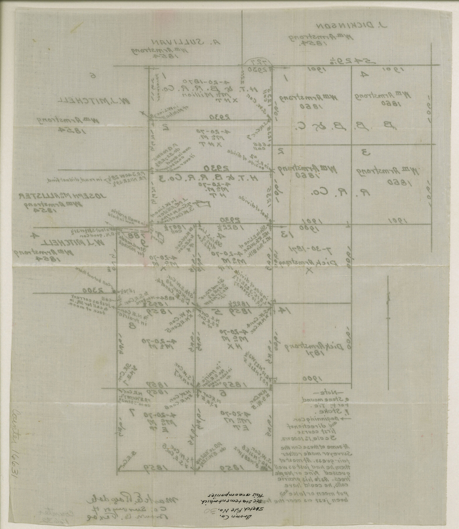
Brown County Sketch File 30
[Sketch and statement regarding H. T. & B. R.R. Co. and E. T. R.R. Co. surveys in the northeast part of the county]
-
Map/Doc
16631
-
Collection
General Map Collection
-
Object Dates
1924/3/10 (Creation Date)
1924/3/12 (File Date)
-
People and Organizations
Mark E. Ragsdale (Surveyor/Engineer)
-
Counties
Brown
-
Subjects
Surveying Sketch File
-
Height x Width
12.7 x 11.0 inches
32.3 x 27.9 cm
-
Medium
multi-page, multi-format
-
Features
Phantom Hill Road
Copperas Creek
Sweet Water Creek
Part of: General Map Collection
Harris County Rolled Sketch 28

Print $20.00
- Digital $50.00
Harris County Rolled Sketch 28
Size 29.8 x 47.3 inches
Map/Doc 6095
Angelina County Working Sketch 36

Print $20.00
- Digital $50.00
Angelina County Working Sketch 36
1957
Size 14.4 x 18.3 inches
Map/Doc 67119
San Patricio County NRC Article 33.136 Sketch 4

Print $3.00
- Digital $50.00
San Patricio County NRC Article 33.136 Sketch 4
Size 11.0 x 17.0 inches
Map/Doc 94695
Culberson County Rolled Sketch 39

Print $20.00
- Digital $50.00
Culberson County Rolled Sketch 39
Size 25.6 x 19.3 inches
Map/Doc 5783
[John Schrier's league]
![286, [John Schrier's league], General Map Collection](https://historictexasmaps.com/wmedia_w700/maps/286.tif.jpg)
Print $2.00
- Digital $50.00
[John Schrier's league]
1847
Size 7.2 x 8.6 inches
Map/Doc 286
Kimble County Working Sketch 30

Print $20.00
- Digital $50.00
Kimble County Working Sketch 30
1942
Size 24.5 x 21.6 inches
Map/Doc 70098
Coast Chart No. 210 Aransas Pass and Corpus Christi Bay with the coast to latitude 27° 12' Texas

Print $20.00
- Digital $50.00
Coast Chart No. 210 Aransas Pass and Corpus Christi Bay with the coast to latitude 27° 12' Texas
1913
Size 27.7 x 18.3 inches
Map/Doc 72798
San Patricio County Sketch File 19

Print $2.00
San Patricio County Sketch File 19
Size 8.0 x 10.5 inches
Map/Doc 36068
Clay County Sketch File 11

Print $4.00
- Digital $50.00
Clay County Sketch File 11
1870
Size 10.1 x 7.9 inches
Map/Doc 18408
Lubbock County Working Sketch 10

Print $20.00
- Digital $50.00
Lubbock County Working Sketch 10
1994
Size 21.8 x 30.1 inches
Map/Doc 70670
Township No. 2 South Range No. 20 West of the Indian Meridian

Print $20.00
- Digital $50.00
Township No. 2 South Range No. 20 West of the Indian Meridian
1875
Size 19.2 x 24.5 inches
Map/Doc 75180
Dawson County Working Sketch 14

Print $20.00
- Digital $50.00
Dawson County Working Sketch 14
1952
Size 15.5 x 12.8 inches
Map/Doc 68558
You may also like
Flight Mission No. CUG-3P, Frame 46, Kleberg County

Print $20.00
- Digital $50.00
Flight Mission No. CUG-3P, Frame 46, Kleberg County
1956
Size 18.5 x 22.2 inches
Map/Doc 86251
Coast Chart No. 210 Aransas Pass and Corpus Christi Bay with the coast to latitude 27° 12' Texas

Print $20.00
- Digital $50.00
Coast Chart No. 210 Aransas Pass and Corpus Christi Bay with the coast to latitude 27° 12' Texas
1887
Size 27.9 x 18.2 inches
Map/Doc 72791
Crane County Boundary File 1a

Print $18.00
- Digital $50.00
Crane County Boundary File 1a
Size 14.2 x 8.7 inches
Map/Doc 51960
Maps & Lists Showing Prison Lands (Oil & Gas) Leased as of June 1955

Digital $50.00
Maps & Lists Showing Prison Lands (Oil & Gas) Leased as of June 1955
Size 8.7 x 11.2 inches
Map/Doc 62869
Flight Mission No. BRA-17M, Frame 5, Jefferson County

Print $20.00
- Digital $50.00
Flight Mission No. BRA-17M, Frame 5, Jefferson County
1953
Size 18.7 x 22.4 inches
Map/Doc 85785
Atascosa County Working Sketch 29

Print $20.00
- Digital $50.00
Atascosa County Working Sketch 29
1977
Size 16.8 x 15.1 inches
Map/Doc 67225
[Leagues 53 through 57]
![92483, [Leagues 53 through 57], Twichell Survey Records](https://historictexasmaps.com/wmedia_w700/maps/92483-1.tif.jpg)
Print $20.00
- Digital $50.00
[Leagues 53 through 57]
1913
Size 17.8 x 19.0 inches
Map/Doc 92483
Presidio County Working Sketch 90

Print $20.00
- Digital $50.00
Presidio County Working Sketch 90
1973
Size 25.5 x 28.1 inches
Map/Doc 71767
Flight Mission No. BRA-6M, Frame 89, Jefferson County

Print $20.00
- Digital $50.00
Flight Mission No. BRA-6M, Frame 89, Jefferson County
1953
Size 18.6 x 22.4 inches
Map/Doc 85432
Flight Mission No. DAG-21K, Frame 124, Matagorda County

Print $20.00
- Digital $50.00
Flight Mission No. DAG-21K, Frame 124, Matagorda County
1952
Size 18.5 x 22.4 inches
Map/Doc 86450
Railroad and County Map of Texas

Print $20.00
- Digital $50.00
Railroad and County Map of Texas
1926
Size 42.9 x 45.2 inches
Map/Doc 65799
[Right of Way & Track Map, The Texas & Pacific Ry. Co. Main Line]
![64659, [Right of Way & Track Map, The Texas & Pacific Ry. Co. Main Line], General Map Collection](https://historictexasmaps.com/wmedia_w700/maps/64659.tif.jpg)
Print $20.00
- Digital $50.00
[Right of Way & Track Map, The Texas & Pacific Ry. Co. Main Line]
Size 11.0 x 18.4 inches
Map/Doc 64659