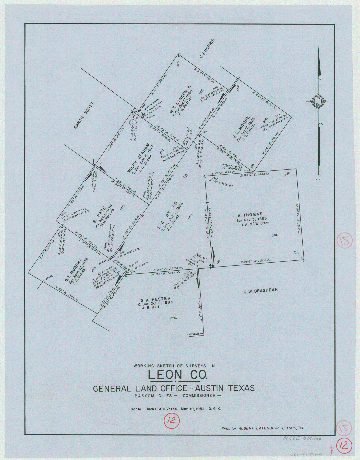
Leon County Working Sketch 12
-
Map/Doc
70411
-
Collection
General Map Collection
-
Object Dates
3/19/1954 (Creation Date)
-
People and Organizations
Otto G. Kurio (Draftsman)
-
Counties
Leon
-
Subjects
Surveying Working Sketch
-
Height x Width
21.9 x 17.1 inches
55.6 x 43.4 cm
-
Scale
1" = 300 varas
Part of: General Map Collection
Edwards County Working Sketch 25

Print $20.00
- Digital $50.00
Edwards County Working Sketch 25
1942
Size 22.6 x 20.8 inches
Map/Doc 68901
Coryell County Working Sketch 19

Print $20.00
- Digital $50.00
Coryell County Working Sketch 19
1970
Size 38.7 x 33.2 inches
Map/Doc 68226
Amistad International Reservoir on Rio Grande 89a

Print $20.00
- Digital $50.00
Amistad International Reservoir on Rio Grande 89a
1949
Size 28.6 x 40.1 inches
Map/Doc 75518
San Patricio County Working Sketch 15

Print $20.00
- Digital $50.00
San Patricio County Working Sketch 15
1951
Size 20.9 x 25.6 inches
Map/Doc 63777
Hill County Sketch File 20

Print $22.00
- Digital $50.00
Hill County Sketch File 20
1854
Size 8.3 x 7.7 inches
Map/Doc 26490
Neches River, Blackburn Bridge Sheet

Print $4.00
- Digital $50.00
Neches River, Blackburn Bridge Sheet
1938
Size 27.6 x 20.5 inches
Map/Doc 65083
Flight Mission No. DQO-3K, Frame 25, Galveston County

Print $20.00
- Digital $50.00
Flight Mission No. DQO-3K, Frame 25, Galveston County
1952
Size 18.8 x 22.4 inches
Map/Doc 85066
Hutchinson County Working Sketch 24

Print $20.00
- Digital $50.00
Hutchinson County Working Sketch 24
1967
Size 27.2 x 40.0 inches
Map/Doc 66384
Calhoun County Rolled Sketch 30

Print $20.00
- Digital $50.00
Calhoun County Rolled Sketch 30
1974
Size 18.6 x 27.6 inches
Map/Doc 5493
Edwards County Working Sketch 80

Print $20.00
- Digital $50.00
Edwards County Working Sketch 80
1963
Size 23.4 x 23.2 inches
Map/Doc 68956
Limestone County Sketch File B

Print $8.00
- Digital $50.00
Limestone County Sketch File B
1878
Size 8.2 x 7.3 inches
Map/Doc 30151
Map of the Central and Montgomery Railroad

Print $20.00
- Digital $50.00
Map of the Central and Montgomery Railroad
1881
Size 12.6 x 36.8 inches
Map/Doc 64141
You may also like
Presidio County Sketch File G

Print $6.00
- Digital $50.00
Presidio County Sketch File G
1913
Size 9.7 x 17.0 inches
Map/Doc 34429
Surveys in Austin's Colony along the east fork of Mill Creek

Print $20.00
- Digital $50.00
Surveys in Austin's Colony along the east fork of Mill Creek
1830
Size 23.7 x 12.6 inches
Map/Doc 208
Ward County Sketch File 12

Print $4.00
- Digital $50.00
Ward County Sketch File 12
Size 14.3 x 8.8 inches
Map/Doc 39638
Howard County Boundary File 2a

Print $9.00
- Digital $50.00
Howard County Boundary File 2a
Size 14.6 x 11.3 inches
Map/Doc 55118
Menard County Sketch File 31

Print $4.00
- Digital $50.00
Menard County Sketch File 31
1978
Size 14.2 x 8.7 inches
Map/Doc 31573
[Block 30 - Jasper Hays]
![92949, [Block 30 - Jasper Hays], Twichell Survey Records](https://historictexasmaps.com/wmedia_w700/maps/92949-1.tif.jpg)
Print $20.00
- Digital $50.00
[Block 30 - Jasper Hays]
Size 25.8 x 17.8 inches
Map/Doc 92949
Jeff Davis County Rolled Sketch 33

Print $20.00
- Digital $50.00
Jeff Davis County Rolled Sketch 33
1986
Size 39.8 x 30.6 inches
Map/Doc 6379
General Highway Map of Garza County, Texas

Print $20.00
- Digital $50.00
General Highway Map of Garza County, Texas
1950
Size 25.9 x 18.8 inches
Map/Doc 92646
Flight Mission No. BQR-13K, Frame 23, Brazoria County

Print $20.00
- Digital $50.00
Flight Mission No. BQR-13K, Frame 23, Brazoria County
1952
Size 18.9 x 22.4 inches
Map/Doc 84071
Leon County Working Sketch 15

Print $20.00
- Digital $50.00
Leon County Working Sketch 15
1958
Size 27.3 x 26.7 inches
Map/Doc 70414
Callahan County, Texas

Print $20.00
- Digital $50.00
Callahan County, Texas
1880
Size 24.1 x 18.4 inches
Map/Doc 681
Loving County Working Sketch 14

Print $40.00
- Digital $50.00
Loving County Working Sketch 14
1957
Size 86.7 x 35.0 inches
Map/Doc 70647