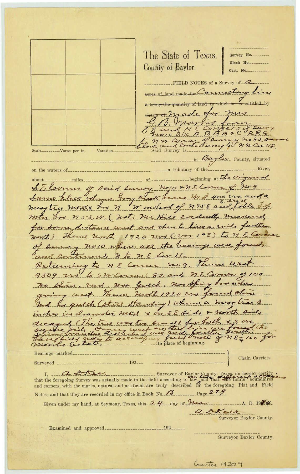
Baylor County Sketch File 24
[Field notes of connecting line and office sketch made for Mrs. G.B. Morris from southeast and northeast corners of survey no. 100, Block A, B. B. B. & C. R.R. Co.]
-
Map/Doc
14209
-
Collection
General Map Collection
-
Object Dates
1934/3/24 (Creation Date)
1934/3/26 (File Date)
-
People and Organizations
A.D. Kerr (Surveyor/Engineer)
-
Counties
Baylor
-
Subjects
Surveying Sketch File
-
Height x Width
13.9 x 8.8 inches
35.3 x 22.4 cm
-
Medium
paper, manuscript
-
Features
Gray Creek
Part of: General Map Collection
Current Miscellaneous File 4

Print $8.00
- Digital $50.00
Current Miscellaneous File 4
1947
Size 11.5 x 9.1 inches
Map/Doc 73723
Refugio County Sketch File 9

Print $4.00
- Digital $50.00
Refugio County Sketch File 9
1850
Size 5.5 x 7.6 inches
Map/Doc 35256
Milam County Rolled Sketch 2

Print $20.00
- Digital $50.00
Milam County Rolled Sketch 2
1954
Size 21.9 x 24.8 inches
Map/Doc 6774
Map of Anderson County

Print $40.00
- Digital $50.00
Map of Anderson County
1895
Size 48.2 x 40.2 inches
Map/Doc 4782
Flight Mission No. DAG-19K, Frame 64, Matagorda County

Print $20.00
- Digital $50.00
Flight Mission No. DAG-19K, Frame 64, Matagorda County
1952
Size 16.3 x 16.3 inches
Map/Doc 86391
San Augustine County Working Sketch 13

Print $20.00
- Digital $50.00
San Augustine County Working Sketch 13
1952
Size 34.0 x 27.6 inches
Map/Doc 63701
Freestone County Working Sketch 23

Print $20.00
- Digital $50.00
Freestone County Working Sketch 23
1982
Size 20.1 x 17.0 inches
Map/Doc 69265
Real County Working Sketch 84

Print $20.00
- Digital $50.00
Real County Working Sketch 84
1986
Size 25.0 x 40.7 inches
Map/Doc 71976
Laguna Madre, Register No. 1476A

Print $40.00
- Digital $50.00
Laguna Madre, Register No. 1476A
1880
Size 31.3 x 53.3 inches
Map/Doc 73604
Motley County Sketch File 13 (N)

Print $10.00
- Digital $50.00
Motley County Sketch File 13 (N)
1911
Size 11.1 x 8.6 inches
Map/Doc 32043
[Map of Line Dividing Fannin and Nacogdoches Districts]
![81919, [Map of Line Dividing Fannin and Nacogdoches Districts], General Map Collection](https://historictexasmaps.com/wmedia_w700/maps/81919-1.tif.jpg)
Print $2.00
- Digital $50.00
[Map of Line Dividing Fannin and Nacogdoches Districts]
1850
Size 11.0 x 8.6 inches
Map/Doc 81919
Cherokee County Working Sketch 27

Print $40.00
- Digital $50.00
Cherokee County Working Sketch 27
1982
Size 42.9 x 59.1 inches
Map/Doc 67982
You may also like
Anderson County Working Sketch 7

Print $20.00
- Digital $50.00
Anderson County Working Sketch 7
1920
Size 27.3 x 30.2 inches
Map/Doc 67006
Trinity River, Irving Sheet

Print $4.00
- Digital $50.00
Trinity River, Irving Sheet
1925
Size 20.7 x 17.9 inches
Map/Doc 65212
Harris County Working Sketch 81

Print $20.00
- Digital $50.00
Harris County Working Sketch 81
1969
Size 23.6 x 30.0 inches
Map/Doc 65973
McLennan County Sketch File 15

Print $4.00
- Digital $50.00
McLennan County Sketch File 15
1872
Size 8.2 x 11.3 inches
Map/Doc 31274
Gillespie County Working Sketch 5

Print $20.00
- Digital $50.00
Gillespie County Working Sketch 5
1972
Size 25.7 x 25.9 inches
Map/Doc 63168

Comanche County Working Sketch 32

Print $20.00
- Digital $50.00
Comanche County Working Sketch 32
1992
Size 23.5 x 38.8 inches
Map/Doc 68166
Crockett County Working Sketch 26

Print $20.00
- Digital $50.00
Crockett County Working Sketch 26
1922
Size 15.3 x 20.3 inches
Map/Doc 68359

Kimble County Sketch File 34

Print $20.00
- Digital $50.00
Kimble County Sketch File 34
1963
Size 26.2 x 16.3 inches
Map/Doc 11931
El Paso County Sketch File 37

Print $4.00
- Digital $50.00
El Paso County Sketch File 37
1987
Size 14.4 x 9.1 inches
Map/Doc 22221
[G. B. & C. Blocks K3 and K4]
![90512, [G. B. & C. Blocks K3 and K4], Twichell Survey Records](https://historictexasmaps.com/wmedia_w700/maps/90512-1.tif.jpg)
Print $20.00
- Digital $50.00
[G. B. & C. Blocks K3 and K4]
Size 14.0 x 14.5 inches
Map/Doc 90512