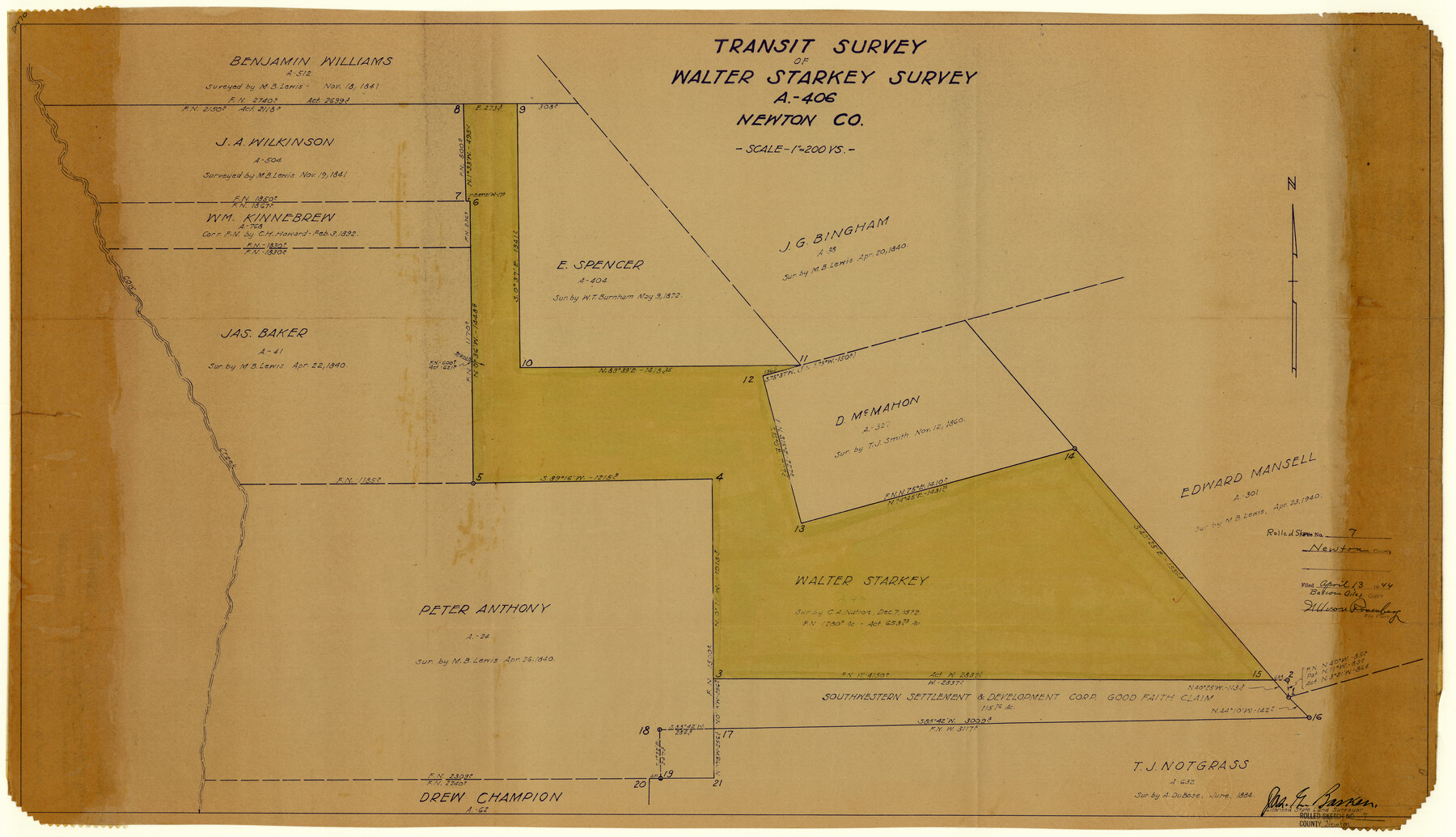
Newton County Rolled Sketch 7
Transit survey of Walter Starkey survey, A-406, Newton Co.
-
Map/Doc
6843
-
Collection
General Map Collection
-
Object Dates
1943/12/15 (Creation Date)
1944/4/13 (File Date)
-
People and Organizations
Jas. G. Barker (Surveyor/Engineer)
-
Counties
Newton
-
Subjects
Surveying Rolled Sketch
-
Height x Width
21.4 x 37.2 inches
54.4 x 94.5 cm
-
Medium
blueprint/diazo
-
Scale
1" = 200 varas
Related maps
Newton County Sketch File 43

Print $12.00
- Digital $50.00
Newton County Sketch File 43
1944
Size 11.2 x 8.6 inches
Map/Doc 32435
Part of: General Map Collection
Hopkins County Boundary File 1

Print $26.00
- Digital $50.00
Hopkins County Boundary File 1
Size 12.3 x 7.9 inches
Map/Doc 55044
Outer Continental Shelf Leasing Maps (Texas Offshore Operations)

Print $20.00
- Digital $50.00
Outer Continental Shelf Leasing Maps (Texas Offshore Operations)
1954
Size 14.7 x 14.2 inches
Map/Doc 75834
Tarrant County Working Sketch 25

Print $20.00
- Digital $50.00
Tarrant County Working Sketch 25
2004
Size 27.3 x 38.0 inches
Map/Doc 83585
Motley County Sketch File 34 (S)

Print $20.00
- Digital $50.00
Motley County Sketch File 34 (S)
1951
Size 26.5 x 13.6 inches
Map/Doc 42149
Padre Island National Seashore, Texas - Dependent Resurvey

Print $4.00
- Digital $50.00
Padre Island National Seashore, Texas - Dependent Resurvey
2001
Size 18.4 x 24.0 inches
Map/Doc 60549
Angelina River, Mud Creek, Sheet 2

Print $4.00
- Digital $50.00
Angelina River, Mud Creek, Sheet 2
1937
Size 26.4 x 18.9 inches
Map/Doc 65076
[Sketch for Mineral Application 24072, San Jacinto River]
![65604, [Sketch for Mineral Application 24072, San Jacinto River], General Map Collection](https://historictexasmaps.com/wmedia_w700/maps/65604.tif.jpg)
Print $20.00
- Digital $50.00
[Sketch for Mineral Application 24072, San Jacinto River]
1929
Size 23.3 x 17.5 inches
Map/Doc 65604
Flight Mission No. DIX-10P, Frame 167, Aransas County

Print $20.00
- Digital $50.00
Flight Mission No. DIX-10P, Frame 167, Aransas County
1956
Size 18.6 x 22.3 inches
Map/Doc 83957
Hopkins County Sketch File 26

Print $4.00
- Digital $50.00
Hopkins County Sketch File 26
Size 8.4 x 6.1 inches
Map/Doc 26736
Taylor County Working Sketch 10

Print $20.00
- Digital $50.00
Taylor County Working Sketch 10
1955
Size 21.6 x 25.5 inches
Map/Doc 69620
Montague County Working Sketch 21

Print $20.00
- Digital $50.00
Montague County Working Sketch 21
1952
Size 33.1 x 39.5 inches
Map/Doc 71087
Zavala County Working Sketch 9

Print $20.00
- Digital $50.00
Zavala County Working Sketch 9
1951
Size 42.0 x 36.4 inches
Map/Doc 62084
You may also like
Railroad Track Map, H&TCRRCo., Falls County, Texas

Print $4.00
- Digital $50.00
Railroad Track Map, H&TCRRCo., Falls County, Texas
1918
Size 11.7 x 18.3 inches
Map/Doc 62853
Potter County Rolled Sketch 13

Print $20.00
- Digital $50.00
Potter County Rolled Sketch 13
2004
Size 19.2 x 23.2 inches
Map/Doc 82479
Caddo-Breckenridge Districts, Stephens County, Texas Ranger-Eastland-Cisco Districts Eastland County, Texas

Print $20.00
- Digital $50.00
Caddo-Breckenridge Districts, Stephens County, Texas Ranger-Eastland-Cisco Districts Eastland County, Texas
1919
Size 34.9 x 44.5 inches
Map/Doc 89808

Map of the chief part of the Western States and part of Virginia engraved to illustrate Mitchell's school and family geography

Print $20.00
- Digital $50.00
Map of the chief part of the Western States and part of Virginia engraved to illustrate Mitchell's school and family geography
1839
Size 11.8 x 17.8 inches
Map/Doc 93499
Mills County Boundary File 1a

Print $60.00
- Digital $50.00
Mills County Boundary File 1a
Size 9.7 x 31.6 inches
Map/Doc 57273
Concho County Sketch File 20

Print $20.00
- Digital $50.00
Concho County Sketch File 20
Size 17.0 x 18.2 inches
Map/Doc 11154
Martha's Vineyard to Block Island Including Western Approach to Cape Cod Canal

Print $20.00
- Digital $50.00
Martha's Vineyard to Block Island Including Western Approach to Cape Cod Canal
1963
Size 37.5 x 45.7 inches
Map/Doc 73554
Flight Mission No. DQO-6K, Frame 31, Galveston County

Print $20.00
- Digital $50.00
Flight Mission No. DQO-6K, Frame 31, Galveston County
1952
Size 18.5 x 22.4 inches
Map/Doc 85097
Flight Mission No. CUG-3P, Frame 82, Kleberg County

Print $20.00
- Digital $50.00
Flight Mission No. CUG-3P, Frame 82, Kleberg County
1956
Size 18.6 x 22.2 inches
Map/Doc 86257
Karnes County Sketch File 1

Print $4.00
- Digital $50.00
Karnes County Sketch File 1
Size 8.8 x 10.7 inches
Map/Doc 28545
Flight Mission No. CRC-5R, Frame 17, Chambers County

Print $20.00
- Digital $50.00
Flight Mission No. CRC-5R, Frame 17, Chambers County
1956
Size 18.8 x 22.5 inches
Map/Doc 84939