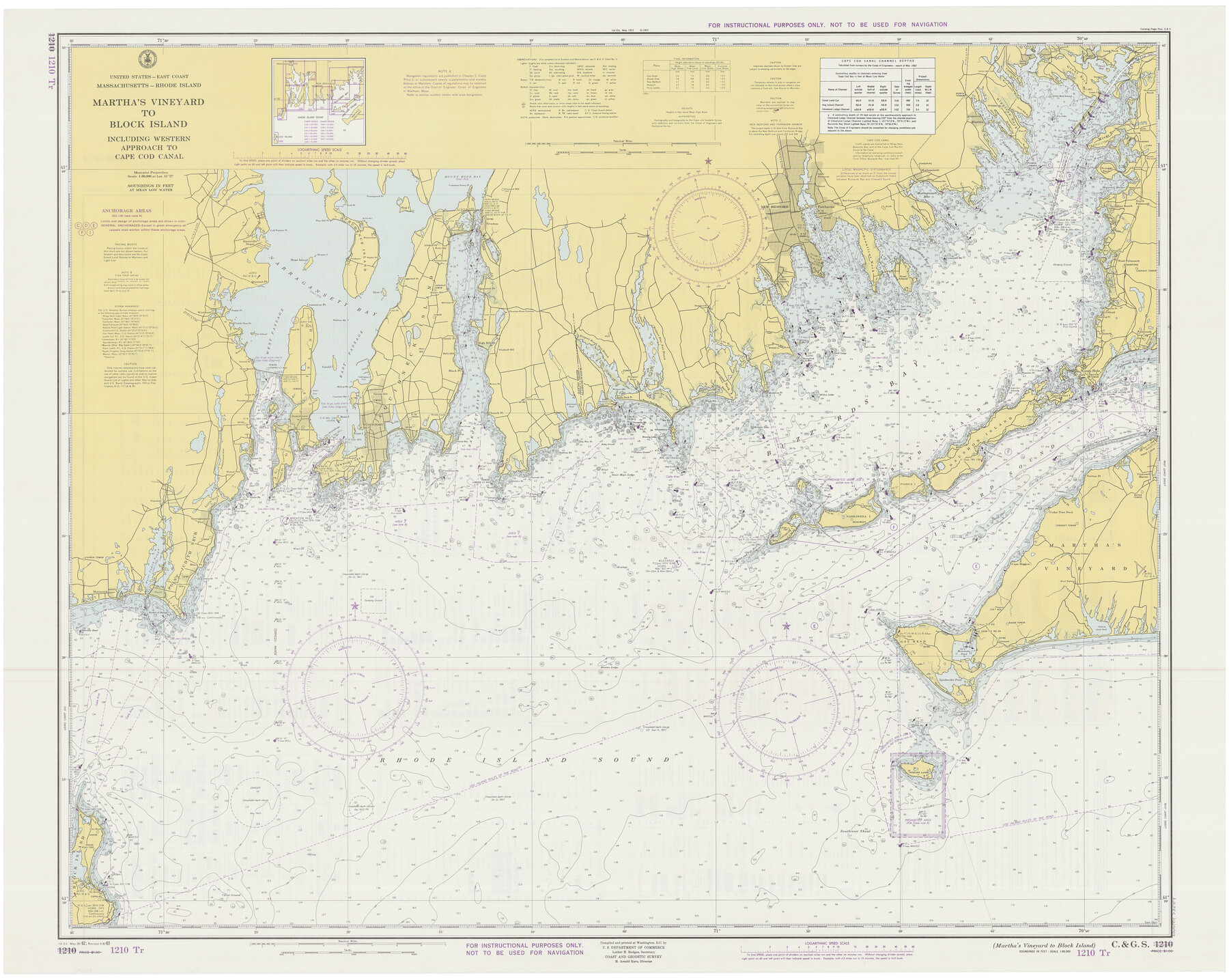
Martha's Vineyard to Block Island Including Western Approach to Cape Cod Canal
-
Map/Doc
73554
-
Collection
General Map Collection
-
Object Dates
4/8/1963 (Creation Date)
-
Subjects
Nautical Charts
-
Height x Width
37.5 x 45.7 inches
95.3 x 116.1 cm
-
Comments
dual-sided map
Part of: General Map Collection
Presidio County Rolled Sketch 135

Print $20.00
- Digital $50.00
Presidio County Rolled Sketch 135
1996
Size 38.4 x 26.8 inches
Map/Doc 7402
[Map of Navarro County]
![81900, [Map of Navarro County], General Map Collection](https://historictexasmaps.com/wmedia_w700/maps/81900.tif.jpg)
Print $20.00
- Digital $50.00
[Map of Navarro County]
1858
Size 18.0 x 23.5 inches
Map/Doc 81900
Coke County Working Sketch 21

Print $20.00
- Digital $50.00
Coke County Working Sketch 21
1949
Size 22.9 x 29.4 inches
Map/Doc 68058
[Sketch & Field Note Calls of Pecos, Terrell & Val Verde Counties, Texas]
![1720, [Sketch & Field Note Calls of Pecos, Terrell & Val Verde Counties, Texas], General Map Collection](https://historictexasmaps.com/wmedia_w700/pdf_converted_jpg/qi_pdf_thumbnail_734.jpg)
Print $20.00
- Digital $50.00
[Sketch & Field Note Calls of Pecos, Terrell & Val Verde Counties, Texas]
1915
Size 19.4 x 24.2 inches
Map/Doc 1720
[Letter regarding surveys in Coryell County]
![69754, [Letter regarding surveys in Coryell County], General Map Collection](https://historictexasmaps.com/wmedia_w700/maps/69754.tif.jpg)
Print $2.00
- Digital $50.00
[Letter regarding surveys in Coryell County]
1846
Size 7.7 x 6.4 inches
Map/Doc 69754
Bell County Sketch File 23

Print $4.00
- Digital $50.00
Bell County Sketch File 23
1873
Size 8.2 x 12.8 inches
Map/Doc 14414
Anderson County Sketch File 11a

Print $6.00
- Digital $50.00
Anderson County Sketch File 11a
1854
Size 8.2 x 8.2 inches
Map/Doc 12768

Bowie County Working Sketch 3

Print $20.00
- Digital $50.00
Bowie County Working Sketch 3
1913
Size 25.5 x 17.1 inches
Map/Doc 67407
Orange County Sketch File 1

Print $6.00
- Digital $50.00
Orange County Sketch File 1
Size 9.6 x 11.5 inches
Map/Doc 33299
Loving County Rolled Sketch 7

Print $20.00
- Digital $50.00
Loving County Rolled Sketch 7
Size 24.1 x 28.4 inches
Map/Doc 7479
Lynn County Rolled Sketch 16

Print $20.00
- Digital $50.00
Lynn County Rolled Sketch 16
1991
Size 18.3 x 42.3 inches
Map/Doc 6652
You may also like
San Antonio & Aransas Pass

Print $40.00
- Digital $50.00
San Antonio & Aransas Pass
Size 30.4 x 81.6 inches
Map/Doc 64634
Flight Mission No. DIX-8P, Frame 71, Aransas County

Print $20.00
- Digital $50.00
Flight Mission No. DIX-8P, Frame 71, Aransas County
1956
Size 18.8 x 22.4 inches
Map/Doc 83902
Travis County Sketch File 48

Print $6.00
- Digital $50.00
Travis County Sketch File 48
1940
Size 11.4 x 8.8 inches
Map/Doc 38377
Public School Land Leagues 1 through 63]
![92487, Public School Land Leagues 1 through 63], Twichell Survey Records](https://historictexasmaps.com/wmedia_w700/maps/92487-1.tif.jpg)
Print $20.00
- Digital $50.00
Public School Land Leagues 1 through 63]
Size 23.9 x 16.8 inches
Map/Doc 92487
Brazos River, Sandpit Extension Sheet

Print $20.00
- Digital $50.00
Brazos River, Sandpit Extension Sheet
1926
Size 31.3 x 36.5 inches
Map/Doc 69663
Map of Texas and part of New Mexico

Print $20.00
Map of Texas and part of New Mexico
1857
Size 17.4 x 23.1 inches
Map/Doc 95284
Travis County Boundary File 20

Print $6.00
- Digital $50.00
Travis County Boundary File 20
Size 14.4 x 9.2 inches
Map/Doc 59454
[Part of Blocks 34 and 35, Township 3 North]
![91287, [Part of Blocks 34 and 35, Township 3 North], Twichell Survey Records](https://historictexasmaps.com/wmedia_w700/maps/91287-1.tif.jpg)
Print $20.00
- Digital $50.00
[Part of Blocks 34 and 35, Township 3 North]
Size 12.7 x 13.5 inches
Map/Doc 91287
McMullen County Sketch File 19

Print $4.00
- Digital $50.00
McMullen County Sketch File 19
Size 12.8 x 8.1 inches
Map/Doc 31371
Zapata County Working Sketch 19

Print $40.00
- Digital $50.00
Zapata County Working Sketch 19
1976
Size 41.2 x 55.5 inches
Map/Doc 62070
Brewster County Sketch File FN-35

Print $8.00
- Digital $50.00
Brewster County Sketch File FN-35
1979
Size 14.2 x 8.9 inches
Map/Doc 15861
Bosque County Working Sketch 5

Print $20.00
- Digital $50.00
Bosque County Working Sketch 5
1935
Size 20.5 x 28.9 inches
Map/Doc 67438