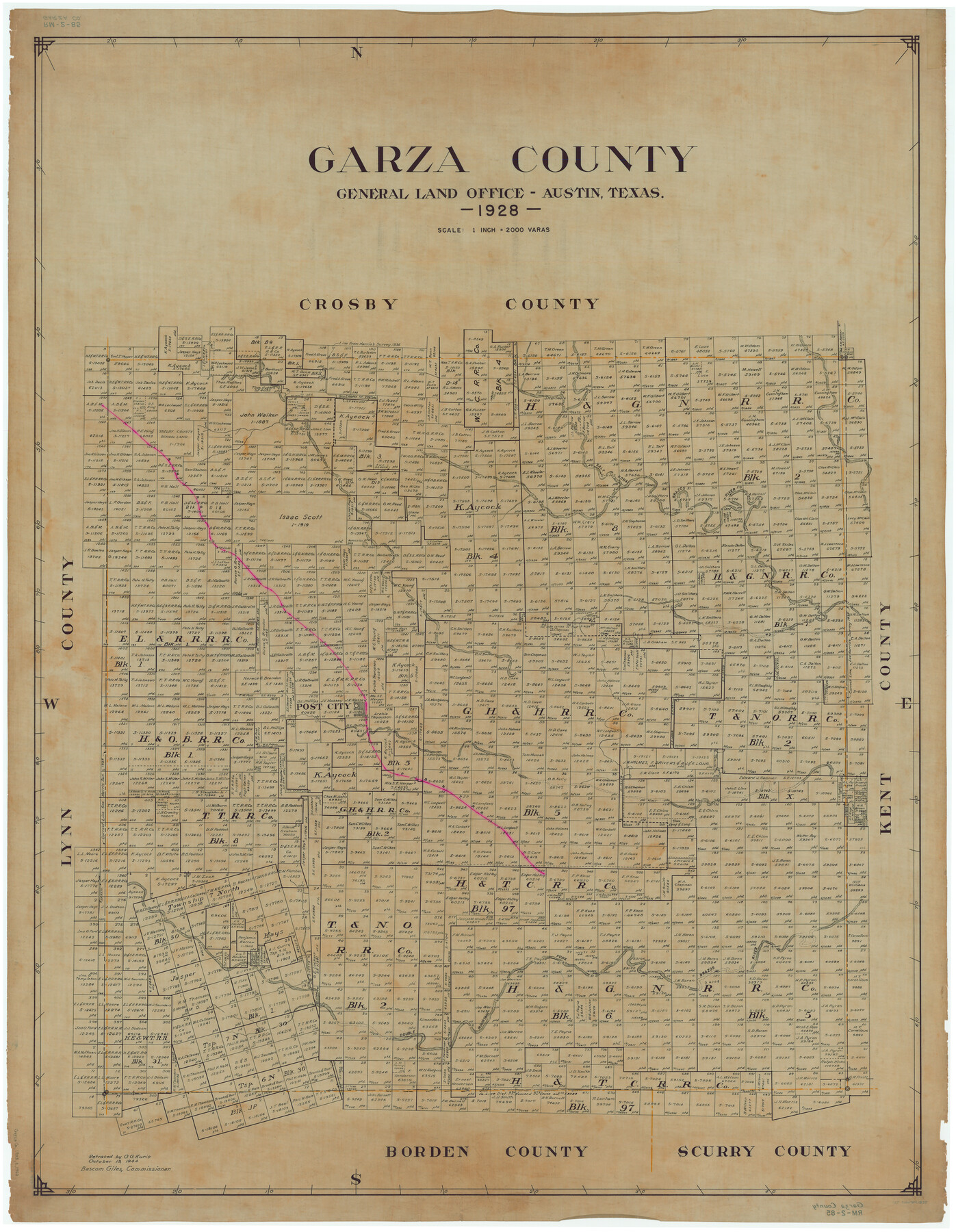
Garza County
RM-2-85
-
Map/Doc
1837
-
Collection
General Map Collection
-
Object Dates
1928 (Creation Date)
-
People and Organizations
Texas General Land Office (Publisher)
Bascom Giles (GLO Commissioner)
-
Counties
Garza
-
Subjects
County
-
Height x Width
47.6 x 37.1 inches
120.9 x 94.2 cm
-
Comments
Retraced October 19, 1944 by O. G. Kurio.
Part of: General Map Collection
Culberson County Rolled Sketch 20

Print $20.00
- Digital $50.00
Culberson County Rolled Sketch 20
1912
Size 30.0 x 18.2 inches
Map/Doc 5653
Crosby County Rolled Sketch 1

Print $20.00
- Digital $50.00
Crosby County Rolled Sketch 1
1950
Size 25.3 x 21.1 inches
Map/Doc 5640
Grayson County Rolled Sketch 1

Print $20.00
- Digital $50.00
Grayson County Rolled Sketch 1
1944
Size 43.4 x 29.0 inches
Map/Doc 6029
Henderson County Working Sketch 12

Print $20.00
- Digital $50.00
Henderson County Working Sketch 12
1915
Size 23.3 x 24.9 inches
Map/Doc 66145
Terrell County Sketch File 41

Print $8.00
- Digital $50.00
Terrell County Sketch File 41
Size 11.3 x 8.8 inches
Map/Doc 38008
Crockett County Working Sketch 36

Print $20.00
- Digital $50.00
Crockett County Working Sketch 36
1927
Size 22.4 x 26.0 inches
Map/Doc 68369
Sutton County Sketch File 41

Print $4.00
- Digital $50.00
Sutton County Sketch File 41
1940
Size 14.4 x 8.6 inches
Map/Doc 37507
Schleicher County Sketch File 15

Print $22.00
- Digital $50.00
Schleicher County Sketch File 15
1928
Size 8.1 x 12.9 inches
Map/Doc 36504
Williamson County

Print $40.00
- Digital $50.00
Williamson County
1888
Size 39.3 x 57.1 inches
Map/Doc 16929
Laguna Madre, T-9211

Print $20.00
- Digital $50.00
Laguna Madre, T-9211
Size 33.0 x 31.1 inches
Map/Doc 73602
Webb County Working Sketch 33

Print $20.00
- Digital $50.00
Webb County Working Sketch 33
1938
Size 27.4 x 35.9 inches
Map/Doc 72398
Rio Grande - North Extension Raymondville Sheet

Print $40.00
- Digital $50.00
Rio Grande - North Extension Raymondville Sheet
1937
Size 16.4 x 56.9 inches
Map/Doc 65104
You may also like
[Block S, Sections 4 and 11]
![92834, [Block S, Sections 4 and 11], Twichell Survey Records](https://historictexasmaps.com/wmedia_w700/maps/92834-1.tif.jpg)
Print $20.00
- Digital $50.00
[Block S, Sections 4 and 11]
1951
Size 14.8 x 12.2 inches
Map/Doc 92834
Sherman County Boundary File 2

Print $34.00
- Digital $50.00
Sherman County Boundary File 2
Size 13.0 x 9.0 inches
Map/Doc 58761
Jasper County Sketch File 29

Print $20.00
- Digital $50.00
Jasper County Sketch File 29
1947
Size 21.0 x 24.8 inches
Map/Doc 11851
Cooke County Sketch File 12

Print $4.00
- Digital $50.00
Cooke County Sketch File 12
Size 10.1 x 8.3 inches
Map/Doc 19246
[Sketch for Mineral Application 26501 - Sabine River, T. A. Oldhausen]
![2846, [Sketch for Mineral Application 26501 - Sabine River, T. A. Oldhausen], General Map Collection](https://historictexasmaps.com/wmedia_w700/maps/2846.tif.jpg)
Print $20.00
- Digital $50.00
[Sketch for Mineral Application 26501 - Sabine River, T. A. Oldhausen]
1931
Size 24.4 x 37.0 inches
Map/Doc 2846
Duval County Rolled Sketch 25

Print $20.00
- Digital $50.00
Duval County Rolled Sketch 25
1944
Size 31.3 x 27.7 inches
Map/Doc 8813
Hudspeth County Sketch File 49

Print $18.00
- Digital $50.00
Hudspeth County Sketch File 49
1986
Size 11.2 x 8.7 inches
Map/Doc 27065
Trinity River, Map of J. B. Bradley's Levee in Valley of Cummins Creek about 2 1/2 Miles South of Rice Showing Proposed Change of Location

Print $2.00
- Digital $50.00
Trinity River, Map of J. B. Bradley's Levee in Valley of Cummins Creek about 2 1/2 Miles South of Rice Showing Proposed Change of Location
1950
Size 13.9 x 16.1 inches
Map/Doc 65246
Stieler Map of 1879

Print $4.00
- Digital $50.00
Stieler Map of 1879
1879
Size 28.9 x 23.1 inches
Map/Doc 76054
Map showing conflict of Rusk Transportation Co. with Lazarus and I. R.R. Co. Surveys

Print $20.00
- Digital $50.00
Map showing conflict of Rusk Transportation Co. with Lazarus and I. R.R. Co. Surveys
1914
Size 28.9 x 16.6 inches
Map/Doc 75825
Clay County Sketch File 38a

Print $6.00
- Digital $50.00
Clay County Sketch File 38a
1939
Size 14.3 x 8.8 inches
Map/Doc 18469
Brazoria County

Print $20.00
- Digital $50.00
Brazoria County
1879
Size 26.6 x 25.1 inches
Map/Doc 859