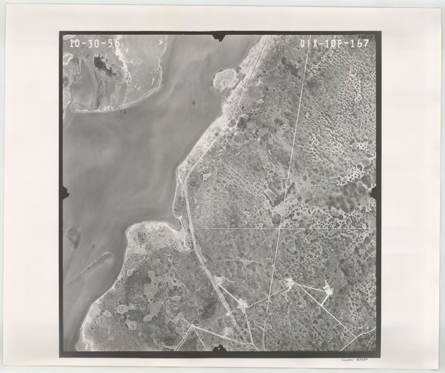
Flight Mission No. DIX-10P, Frame 167, Aransas County
DIX-10P-167
-
Map/Doc
83957
-
Collection
General Map Collection
-
Object Dates
1956/10/30 (Creation Date)
-
People and Organizations
U. S. Department of Agriculture (Publisher)
-
Counties
Aransas
-
Subjects
Aerial Photograph
-
Height x Width
18.6 x 22.3 inches
47.2 x 56.6 cm
-
Comments
Flown by V. L. Beavers and Associates of San Antonio, Texas.
Part of: General Map Collection
Copy of Surveyor's Field Book, Morris Browning - In Blocks 7, 5 & 4, I&GNRRCo., Hutchinson and Carson Counties, Texas

Print $2.00
- Digital $50.00
Copy of Surveyor's Field Book, Morris Browning - In Blocks 7, 5 & 4, I&GNRRCo., Hutchinson and Carson Counties, Texas
1888
Size 6.9 x 8.8 inches
Map/Doc 62264
Childress County Rolled Sketch 9D

Print $3.00
- Digital $50.00
Childress County Rolled Sketch 9D
1945
Size 16.0 x 10.0 inches
Map/Doc 78221
Reeves County Boundary File 73a

Print $16.00
- Digital $50.00
Reeves County Boundary File 73a
Size 13.3 x 8.2 inches
Map/Doc 58208
Brewster County Rolled Sketch 70

Print $20.00
- Digital $50.00
Brewster County Rolled Sketch 70
Size 23.6 x 20.1 inches
Map/Doc 5236
Wheeler County Rolled Sketch 3

Print $20.00
- Digital $50.00
Wheeler County Rolled Sketch 3
Size 31.9 x 21.9 inches
Map/Doc 8239
Flight Mission No. DAH-17M, Frame 63, Orange County

Print $20.00
- Digital $50.00
Flight Mission No. DAH-17M, Frame 63, Orange County
1953
Size 18.6 x 22.4 inches
Map/Doc 86897
PSL Field Notes for Block C24 in Loving and Winkler Counties, and Blocks C22 and C23 in Winkler County

PSL Field Notes for Block C24 in Loving and Winkler Counties, and Blocks C22 and C23 in Winkler County
Map/Doc 81677
Comal County Sketch File 8 1/2

Print $22.00
- Digital $50.00
Comal County Sketch File 8 1/2
1858
Size 9.2 x 7.4 inches
Map/Doc 19015
Van Zandt County Sketch File 34

Print $4.00
- Digital $50.00
Van Zandt County Sketch File 34
1861
Size 7.8 x 15.0 inches
Map/Doc 39472
Coryell County Sketch File 7

Print $23.00
- Digital $50.00
Coryell County Sketch File 7
1859
Size 8.3 x 12.7 inches
Map/Doc 19349
Map of Comanche County

Print $40.00
- Digital $50.00
Map of Comanche County
1895
Size 47.5 x 50.0 inches
Map/Doc 4735
Trinity County Sketch File 38

Print $8.00
- Digital $50.00
Trinity County Sketch File 38
1948
Size 14.5 x 8.9 inches
Map/Doc 38593
You may also like
[Block K5, Section 13]
![91451, [Block K5, Section 13], Twichell Survey Records](https://historictexasmaps.com/wmedia_w700/maps/91451-1.tif.jpg)
Print $3.00
- Digital $50.00
[Block K5, Section 13]
Size 11.4 x 10.4 inches
Map/Doc 91451
Erath County Working Sketch 6

Print $20.00
- Digital $50.00
Erath County Working Sketch 6
1920
Size 40.9 x 33.1 inches
Map/Doc 69087
Purnell and Lovell Empresario Colony. October 22, 1825

Print $20.00
Purnell and Lovell Empresario Colony. October 22, 1825
2020
Size 18.1 x 21.6 inches
Map/Doc 96005
Houston County Rolled Sketch 10

Print $20.00
- Digital $50.00
Houston County Rolled Sketch 10
1988
Size 31.9 x 25.3 inches
Map/Doc 6230
Anderson County Sketch File 32

Print $4.00
- Digital $50.00
Anderson County Sketch File 32
2002
Size 11.3 x 8.8 inches
Map/Doc 78312
Nacogdoches County Sketch File 7

Print $6.00
- Digital $50.00
Nacogdoches County Sketch File 7
1875
Size 10.4 x 15.0 inches
Map/Doc 32250
Map of Germany, Switzerland and Northern Italy engraved to illustrate Mitchell's school and family geography

Print $20.00
- Digital $50.00
Map of Germany, Switzerland and Northern Italy engraved to illustrate Mitchell's school and family geography
1840
Size 11.8 x 9.5 inches
Map/Doc 93504
Sketch of surveys in Harrison & Marion Cos. showing Caddo Lake & Subdivisions

Print $5.00
- Digital $50.00
Sketch of surveys in Harrison & Marion Cos. showing Caddo Lake & Subdivisions
1955
Size 32.6 x 32.5 inches
Map/Doc 2895
Milam County Working Sketch 3

Print $20.00
- Digital $50.00
Milam County Working Sketch 3
Size 29.0 x 38.4 inches
Map/Doc 71018
Coke County Working Sketch 17

Print $20.00
- Digital $50.00
Coke County Working Sketch 17
1948
Size 18.2 x 19.4 inches
Map/Doc 68054
Map of Jack County

Print $20.00
- Digital $50.00
Map of Jack County
Size 18.7 x 15.9 inches
Map/Doc 3703
Lampasas County Working Sketch 8

Print $20.00
- Digital $50.00
Lampasas County Working Sketch 8
1958
Size 36.4 x 37.1 inches
Map/Doc 70285