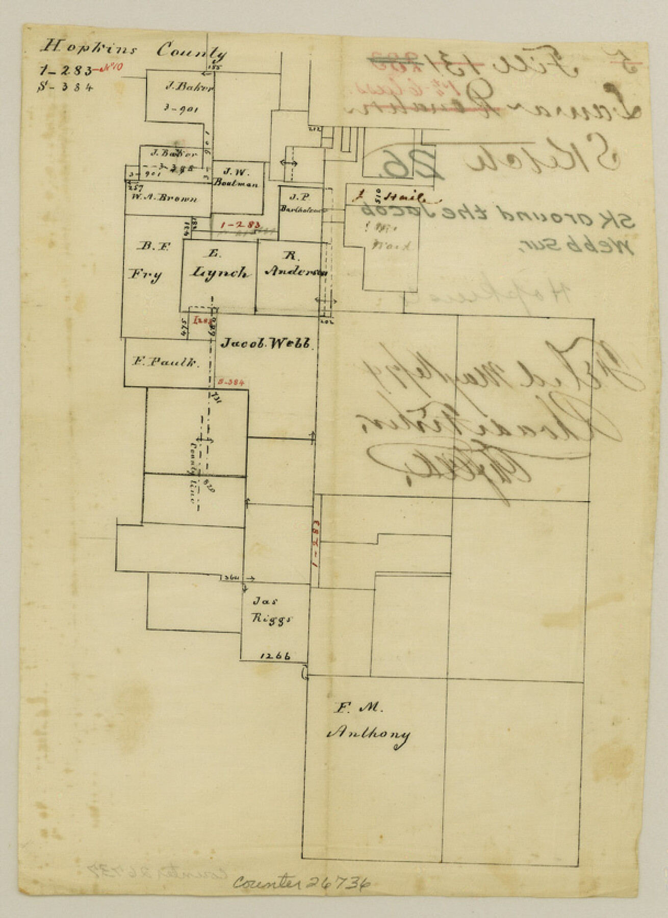
Hopkins County Sketch File 26
[Sketch around the Jacob Webb survey]
-
Map/Doc
26736
-
Collection
General Map Collection
-
Object Dates
5/16/1874 (File Date)
-
Counties
Hopkins Hunt
-
Subjects
Surveying Sketch File
-
Height x Width
8.4 x 6.1 inches
21.3 x 15.5 cm
-
Medium
paper, manuscript
Part of: General Map Collection
[Surveys along the Sabine River made under G.W. Smyth, Commissioner]
![90, [Surveys along the Sabine River made under G.W. Smyth, Commissioner], General Map Collection](https://historictexasmaps.com/wmedia_w700/maps/90.tif.jpg)
Print $20.00
- Digital $50.00
[Surveys along the Sabine River made under G.W. Smyth, Commissioner]
1837
Size 13.9 x 17.0 inches
Map/Doc 90
Martin County Working Sketch 18

Print $20.00
- Digital $50.00
Martin County Working Sketch 18
1982
Size 39.9 x 37.4 inches
Map/Doc 70836

Marion County Working Sketch 37

Print $20.00
- Digital $50.00
Marion County Working Sketch 37
1986
Size 30.0 x 43.0 inches
Map/Doc 70813
Flight Mission No. DAG-23K, Frame 179, Matagorda County

Print $20.00
- Digital $50.00
Flight Mission No. DAG-23K, Frame 179, Matagorda County
1953
Size 18.5 x 22.4 inches
Map/Doc 86514
Maps of Gulf Intracoastal Waterway, Texas - Sabine River to the Rio Grande and connecting waterways including ship channels

Print $20.00
- Digital $50.00
Maps of Gulf Intracoastal Waterway, Texas - Sabine River to the Rio Grande and connecting waterways including ship channels
1966
Size 14.5 x 22.1 inches
Map/Doc 61917
Culberson County Working Sketch 60

Print $40.00
- Digital $50.00
Culberson County Working Sketch 60
1974
Size 74.7 x 32.7 inches
Map/Doc 68514
Pecos County Working Sketch 92

Print $40.00
- Digital $50.00
Pecos County Working Sketch 92
1966
Size 31.4 x 62.2 inches
Map/Doc 71565
Winkler County Working Sketch 5

Print $40.00
- Digital $50.00
Winkler County Working Sketch 5
1957
Size 31.1 x 131.9 inches
Map/Doc 72599
Andrews County Working Sketch 25

Print $40.00
- Digital $50.00
Andrews County Working Sketch 25
1980
Size 70.6 x 44.0 inches
Map/Doc 67071
Pressler's Map of the State of Texas

Print $40.00
- Digital $50.00
Pressler's Map of the State of Texas
1858
Size 47.6 x 51.9 inches
Map/Doc 709
Mason County Working Sketch 18

Print $20.00
- Digital $50.00
Mason County Working Sketch 18
1980
Size 19.4 x 15.0 inches
Map/Doc 70854
You may also like
Montgomery County Working Sketch 37

Print $20.00
- Digital $50.00
Montgomery County Working Sketch 37
1953
Size 24.5 x 33.8 inches
Map/Doc 71144
Castro County Working Sketch 4

Print $20.00
- Digital $50.00
Castro County Working Sketch 4
1920
Size 17.0 x 16.2 inches
Map/Doc 67899
[Gulf, Colorado & Santa Fe Railway Company]
![64410, [Gulf, Colorado & Santa Fe Railway Company], General Map Collection](https://historictexasmaps.com/wmedia_w700/maps/64410.tif.jpg)
Print $40.00
- Digital $50.00
[Gulf, Colorado & Santa Fe Railway Company]
1893
Size 21.5 x 121.2 inches
Map/Doc 64410
Outer Continental Shelf Leasing Maps (Texas Offshore Operations)

Print $20.00
- Digital $50.00
Outer Continental Shelf Leasing Maps (Texas Offshore Operations)
Size 20.7 x 15.1 inches
Map/Doc 75848
Flight Mission No. CUG-3P, Frame 168, Kleberg County

Print $20.00
- Digital $50.00
Flight Mission No. CUG-3P, Frame 168, Kleberg County
1956
Size 18.6 x 22.3 inches
Map/Doc 86288
Hemphill County Rolled Sketch 14

Print $20.00
- Digital $50.00
Hemphill County Rolled Sketch 14
1941
Size 45.0 x 22.2 inches
Map/Doc 9155
Angelina County Working Sketch 43

Print $20.00
- Digital $50.00
Angelina County Working Sketch 43
1963
Size 23.1 x 34.5 inches
Map/Doc 67126
[Block V and surrounding surveys]
![90292, [Block V and surrounding surveys], Twichell Survey Records](https://historictexasmaps.com/wmedia_w700/maps/90292-1.tif.jpg)
Print $3.00
- Digital $50.00
[Block V and surrounding surveys]
Size 11.9 x 12.5 inches
Map/Doc 90292
Culberson County Working Sketch 60
Print $40.00
- Digital $50.00
Culberson County Working Sketch 60
1974
Size 74.7 x 32.7 inches
Map/Doc 68514

Duval County Boundary File 3b

Print $4.00
- Digital $50.00
Duval County Boundary File 3b
Size 12.9 x 8.2 inches
Map/Doc 52730
[E. L. & R. R. RR. Company, Block LC2]
![90663, [E. L. & R. R. RR. Company, Block LC2], Twichell Survey Records](https://historictexasmaps.com/wmedia_w700/maps/90663-1.tif.jpg)
Print $2.00
- Digital $50.00
[E. L. & R. R. RR. Company, Block LC2]
1907
Size 9.7 x 7.9 inches
Map/Doc 90663