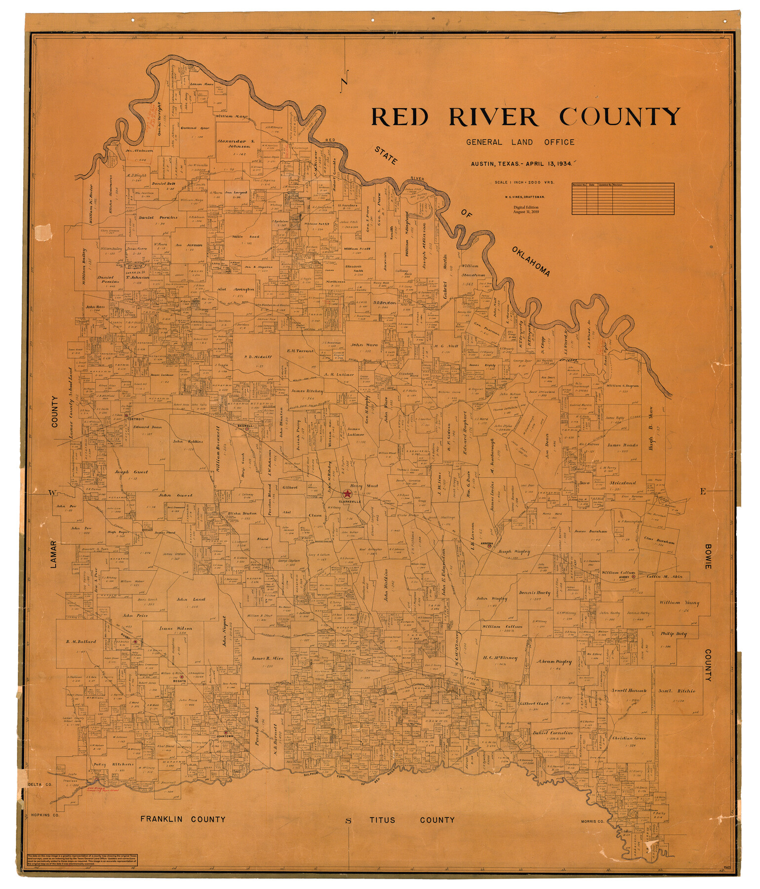
Red River County
General Land Office Official County Map
-
Map/Doc
95623
-
Collection
General Map Collection
-
Object Dates
2019/8/31 (Revision Date)
1934/4/13 (Creation Date)
-
People and Organizations
Cheyenne Betancourt (Draftsman)
W.S. Vines (Draftsman)
-
Counties
Red River
-
Subjects
County OCM
-
Height x Width
47.0 x 40.2 inches
119.4 x 102.1 cm
-
Medium
digital image
-
Scale
1" = 2000 varas
Part of: General Map Collection
Garza County Working Sketch 5

Print $20.00
- Digital $50.00
Garza County Working Sketch 5
1943
Size 19.4 x 34.7 inches
Map/Doc 63152
Terrell County Sketch File 40

Print $6.00
- Digital $50.00
Terrell County Sketch File 40
1995
Size 14.2 x 8.9 inches
Map/Doc 38005
Terry County Sketch File 3

Print $20.00
- Digital $50.00
Terry County Sketch File 3
1948
Size 16.2 x 39.0 inches
Map/Doc 10390

Webb County Sketch File C

Print $10.00
- Digital $50.00
Webb County Sketch File C
1915
Size 14.4 x 8.8 inches
Map/Doc 39668
Coke County Boundary File 2

Print $64.00
- Digital $50.00
Coke County Boundary File 2
Size 49.0 x 9.0 inches
Map/Doc 51580
Presidio County Rolled Sketch 6

Print $40.00
- Digital $50.00
Presidio County Rolled Sketch 6
1949
Size 56.8 x 32.2 inches
Map/Doc 9761
Harris County Historic Topographic 30

Print $20.00
- Digital $50.00
Harris County Historic Topographic 30
1915
Size 29.2 x 22.7 inches
Map/Doc 65841
Flight Mission No. BQR-9K, Frame 45, Brazoria County

Print $20.00
- Digital $50.00
Flight Mission No. BQR-9K, Frame 45, Brazoria County
1952
Size 18.7 x 22.3 inches
Map/Doc 84049
Henderson County Working Sketch 39

Print $20.00
- Digital $50.00
Henderson County Working Sketch 39
1982
Size 24.3 x 19.0 inches
Map/Doc 66172
Brewster County Sketch File 47

Print $12.00
- Digital $50.00
Brewster County Sketch File 47
1939
Size 14.1 x 8.8 inches
Map/Doc 16321
Fisher County Sketch File A

Print $20.00
- Digital $50.00
Fisher County Sketch File A
1901
Size 33.1 x 22.8 inches
Map/Doc 11482
You may also like
Flight Mission No. CRC-3R, Frame 196, Chambers County

Print $20.00
- Digital $50.00
Flight Mission No. CRC-3R, Frame 196, Chambers County
1956
Size 18.7 x 22.3 inches
Map/Doc 84851
Jefferson County Sketch File 15b

Print $26.00
- Digital $50.00
Jefferson County Sketch File 15b
Size 17.4 x 33.2 inches
Map/Doc 11869
Morris County Rolled Sketch 2A

Print $20.00
- Digital $50.00
Morris County Rolled Sketch 2A
Size 24.0 x 18.8 inches
Map/Doc 10240
Real County Sketch File 8

Print $20.00
- Digital $50.00
Real County Sketch File 8
1931
Size 19.5 x 21.6 inches
Map/Doc 12230
Blanco County Working Sketch 23

Print $40.00
- Digital $50.00
Blanco County Working Sketch 23
1962
Size 52.4 x 38.5 inches
Map/Doc 67383
Galveston County NRC Article 33.136 Sketch 62

Print $28.00
- Digital $50.00
Galveston County NRC Article 33.136 Sketch 62
2009
Size 24.0 x 36.0 inches
Map/Doc 94596
Hemphill County Working Sketch 26

Print $40.00
- Digital $50.00
Hemphill County Working Sketch 26
1974
Size 57.2 x 48.3 inches
Map/Doc 66121
Ward County Working Sketch 51

Print $40.00
- Digital $50.00
Ward County Working Sketch 51
1980
Size 34.4 x 52.1 inches
Map/Doc 72357
[Sketch for Mineral Application 36486 and 38244 - Liberty County]
![65622, [Sketch for Mineral Application 36486 and 38244 - Liberty County], General Map Collection](https://historictexasmaps.com/wmedia_w700/maps/65622.tif.jpg)
Print $20.00
- Digital $50.00
[Sketch for Mineral Application 36486 and 38244 - Liberty County]
1976
Size 24.0 x 43.9 inches
Map/Doc 65622
Navarro County Sketch File 14

Print $4.00
- Digital $50.00
Navarro County Sketch File 14
1873
Size 8.4 x 10.2 inches
Map/Doc 32326
League 206 Ochiltree County School Land

Print $20.00
- Digital $50.00
League 206 Ochiltree County School Land
Size 24.0 x 19.5 inches
Map/Doc 92481
Winkler County, Texas

Print $20.00
- Digital $50.00
Winkler County, Texas
1889
Size 24.6 x 19.0 inches
Map/Doc 658