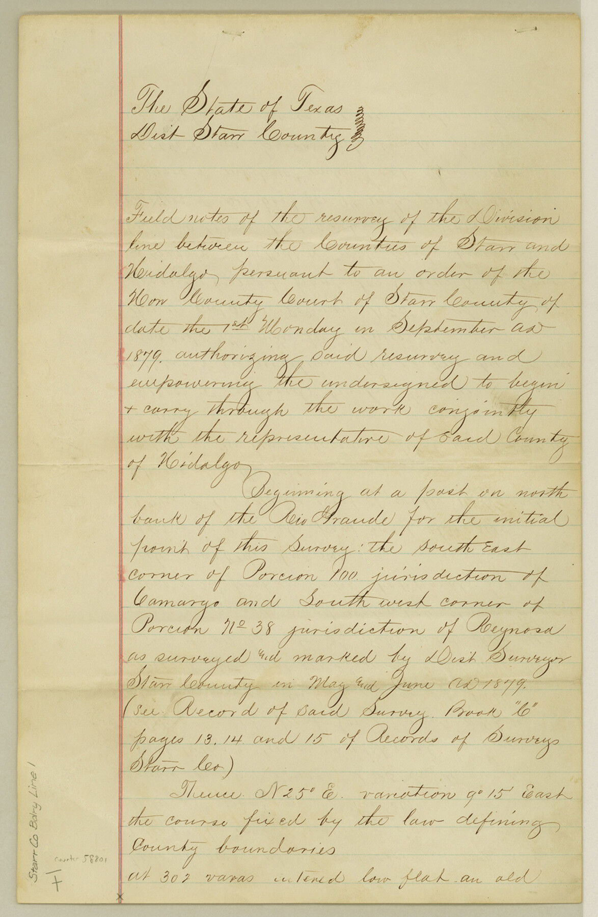
Starr County Boundary File 1
Field Notes Division Line Starr & Hidalgo Counties
-
Map/Doc
58801
-
Collection
General Map Collection
-
Counties
Starr
-
Subjects
County Boundaries
-
Height x Width
13.0 x 8.5 inches
33.0 x 21.6 cm
Part of: General Map Collection
Outer Continental Shelf Leasing Maps (Texas Offshore Operations)

Print $20.00
- Digital $50.00
Outer Continental Shelf Leasing Maps (Texas Offshore Operations)
1954
Size 14.7 x 14.2 inches
Map/Doc 75834
Presidio County Sketch File 98

Print $44.00
- Digital $50.00
Presidio County Sketch File 98
1955
Size 11.3 x 8.8 inches
Map/Doc 34783
Map of Jack County

Print $20.00
- Digital $50.00
Map of Jack County
1895
Size 47.6 x 38.0 inches
Map/Doc 4988
Trinity County Working Sketch 18

Print $20.00
- Digital $50.00
Trinity County Working Sketch 18
1982
Size 13.4 x 11.1 inches
Map/Doc 69467
Texas compiled from the latest and best authorities

Print $20.00
- Digital $50.00
Texas compiled from the latest and best authorities
1845
Size 12.0 x 14.6 inches
Map/Doc 93922
Archer County Boundary File 1

Print $26.00
- Digital $50.00
Archer County Boundary File 1
Size 14.2 x 8.8 inches
Map/Doc 50082
Flight Mission No. CRK-8P, Frame 121, Refugio County

Print $20.00
- Digital $50.00
Flight Mission No. CRK-8P, Frame 121, Refugio County
1956
Size 18.3 x 22.2 inches
Map/Doc 86976
Old Miscellaneous File 36

Print $4.00
- Digital $50.00
Old Miscellaneous File 36
1891
Size 11.3 x 8.8 inches
Map/Doc 75759
Wilson County Working Sketch 3

Print $20.00
- Digital $50.00
Wilson County Working Sketch 3
1952
Size 33.6 x 33.2 inches
Map/Doc 72583
Chambers County NRC Article 33.136 Sketch 12

Print $30.00
- Digital $50.00
Chambers County NRC Article 33.136 Sketch 12
2020
Size 24.0 x 35.9 inches
Map/Doc 96441
Map of Navisota County

Print $20.00
- Digital $50.00
Map of Navisota County
Size 27.5 x 19.6 inches
Map/Doc 3328
Controlled Mosaic by Jack Amman Photogrammetric Engineers, Inc - Sheet 42

Print $20.00
- Digital $50.00
Controlled Mosaic by Jack Amman Photogrammetric Engineers, Inc - Sheet 42
1954
Size 20.0 x 24.0 inches
Map/Doc 83499
You may also like
[Wilson Strickland Survey and Vicinity, Exhibit L]
![91377, [Wilson Strickland Survey and Vicinity, Exhibit L], Twichell Survey Records](https://historictexasmaps.com/wmedia_w700/maps/91377-1.tif.jpg)
Print $20.00
- Digital $50.00
[Wilson Strickland Survey and Vicinity, Exhibit L]
Size 32.8 x 27.1 inches
Map/Doc 91377
Runnels County Rolled Sketch 54

Print $20.00
- Digital $50.00
Runnels County Rolled Sketch 54
Size 11.5 x 18.2 inches
Map/Doc 82576
Fisher County Sketch File 21

Print $6.00
- Digital $50.00
Fisher County Sketch File 21
Size 10.3 x 17.0 inches
Map/Doc 22649
Map of Bexar County

Print $20.00
- Digital $50.00
Map of Bexar County
1878
Size 23.5 x 26.6 inches
Map/Doc 3299
Val Verde County Sketch File A2

Print $10.00
- Digital $50.00
Val Verde County Sketch File A2
1916
Size 14.5 x 9.1 inches
Map/Doc 39041

[Surveys in the vicinity of Falls County School Land]
![90168, [Surveys in the vicinity of Falls County School Land], Twichell Survey Records](https://historictexasmaps.com/wmedia_w700/maps/90168-1.tif.jpg)
Print $20.00
- Digital $50.00
[Surveys in the vicinity of Falls County School Land]
Size 32.5 x 37.1 inches
Map/Doc 90168
Flight Mission No. CRC-3R, Frame 94, Chambers County

Print $20.00
- Digital $50.00
Flight Mission No. CRC-3R, Frame 94, Chambers County
1956
Size 18.5 x 22.3 inches
Map/Doc 84832
[Strickland Survey Sketch Showing Abercrombie Corner, Exhibit C]
![91370, [Strickland Survey Sketch Showing Abercrombie Corner, Exhibit C], Twichell Survey Records](https://historictexasmaps.com/wmedia_w700/maps/91370-1.tif.jpg)
Print $20.00
- Digital $50.00
[Strickland Survey Sketch Showing Abercrombie Corner, Exhibit C]
Size 25.3 x 19.1 inches
Map/Doc 91370
Map of Cooke County

Print $20.00
- Digital $50.00
Map of Cooke County
1868
Size 21.7 x 17.9 inches
Map/Doc 3439
Map of Somervell County

Print $20.00
- Digital $50.00
Map of Somervell County
1875
Size 21.0 x 22.0 inches
Map/Doc 4043
Crockett County Working Sketch 59

Print $20.00
- Digital $50.00
Crockett County Working Sketch 59
1955
Size 46.1 x 29.3 inches
Map/Doc 68392