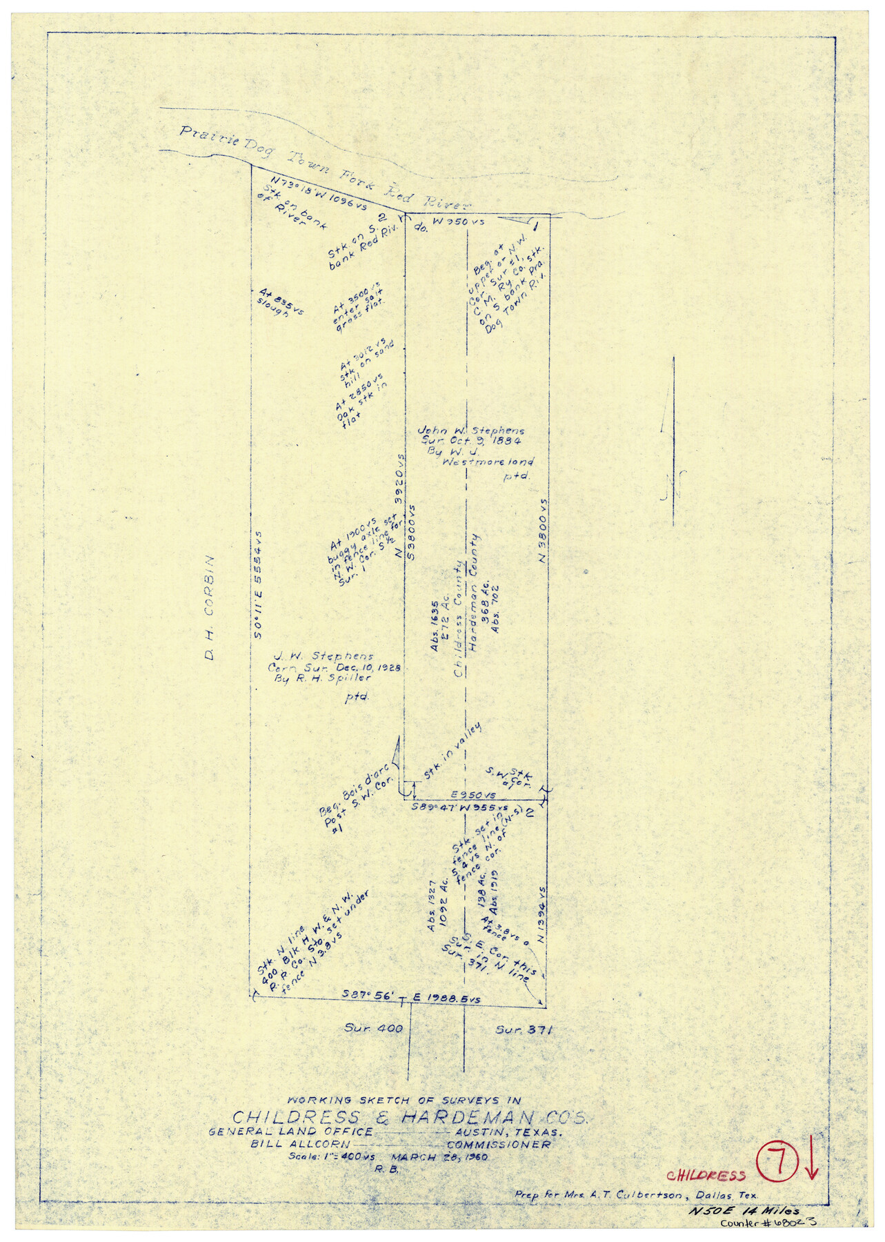
Childress County Working Sketch 7
-
Map/Doc
68023
-
Collection
General Map Collection
-
Object Dates
3/28/1960 (Creation Date)
-
Counties
Childress Hardeman
-
Subjects
Surveying Working Sketch
-
Height x Width
20.7 x 14.8 inches
52.6 x 37.6 cm
-
Scale
1" = 400 varas
Part of: General Map Collection
McMullen County Rolled Sketch 22

Print $20.00
- Digital $50.00
McMullen County Rolled Sketch 22
2004
Size 15.3 x 24.6 inches
Map/Doc 88824
Garza County Sketch File 23

Print $6.00
- Digital $50.00
Garza County Sketch File 23
1907
Size 11.3 x 8.7 inches
Map/Doc 24080
Map of the United States of Mexico drawn and compiled from the latest Mexican and United States Government authorities, and other reliable sources

Print $20.00
- Digital $50.00
Map of the United States of Mexico drawn and compiled from the latest Mexican and United States Government authorities, and other reliable sources
1895
Size 17.3 x 24.8 inches
Map/Doc 94083
Flight Mission No. CRC-1R, Frame 38, Chambers County

Print $20.00
- Digital $50.00
Flight Mission No. CRC-1R, Frame 38, Chambers County
1956
Size 18.7 x 22.4 inches
Map/Doc 84706
Montgomery County Working Sketch 42

Print $20.00
- Digital $50.00
Montgomery County Working Sketch 42
1956
Size 21.3 x 32.8 inches
Map/Doc 71149
Liberty County Rolled Sketch 18

Print $11.00
- Digital $50.00
Liberty County Rolled Sketch 18
1859
Size 10.1 x 15.2 inches
Map/Doc 46540
McCulloch County Working Sketch 3

Print $20.00
- Digital $50.00
McCulloch County Working Sketch 3
1951
Size 30.9 x 36.8 inches
Map/Doc 70678
Rockwall County

Print $20.00
- Digital $50.00
Rockwall County
1874
Size 20.3 x 18.6 inches
Map/Doc 3998
Hutchinson County Boundary File 4a

Print $40.00
- Digital $50.00
Hutchinson County Boundary File 4a
Size 8.7 x 51.7 inches
Map/Doc 55313
Shelby County Working Sketch 10

Print $20.00
- Digital $50.00
Shelby County Working Sketch 10
1945
Size 42.8 x 43.9 inches
Map/Doc 63863
Index sheet to accompany map of survey for connecting the inland waters along margin of the Gulf of Mexico from Donaldsonville in Louisiana to the Rio Grande River in Texas

Print $20.00
- Digital $50.00
Index sheet to accompany map of survey for connecting the inland waters along margin of the Gulf of Mexico from Donaldsonville in Louisiana to the Rio Grande River in Texas
Size 18.2 x 27.4 inches
Map/Doc 72690
Uvalde County Working Sketch 39

Print $20.00
- Digital $50.00
Uvalde County Working Sketch 39
1975
Size 28.0 x 45.3 inches
Map/Doc 72109
You may also like
Travis County Appraisal District Plat Map 4_1301

Print $20.00
- Digital $50.00
Travis County Appraisal District Plat Map 4_1301
Size 21.5 x 26.4 inches
Map/Doc 94213
Harrison County

Print $20.00
- Digital $50.00
Harrison County
1857
Size 20.3 x 21.0 inches
Map/Doc 1116
Presidio County Rolled Sketch 39

Print $20.00
- Digital $50.00
Presidio County Rolled Sketch 39
Size 16.0 x 22.0 inches
Map/Doc 7336
Hemphill County Working Sketch 22

Print $40.00
- Digital $50.00
Hemphill County Working Sketch 22
1973
Size 76.0 x 30.2 inches
Map/Doc 66117
Yellow Fever Deaths in Texas and Louisiana

Yellow Fever Deaths in Texas and Louisiana
2022
Size 8.5 x 11.0 inches
Map/Doc 97094
Map of Port Bolivar

Print $20.00
- Digital $50.00
Map of Port Bolivar
1893
Size 24.9 x 18.5 inches
Map/Doc 2191
Flight Mission No. BRA-8M, Frame 85, Jefferson County

Print $20.00
- Digital $50.00
Flight Mission No. BRA-8M, Frame 85, Jefferson County
1953
Size 18.7 x 22.3 inches
Map/Doc 85605
Jones County Rolled Sketch 4

Print $20.00
- Digital $50.00
Jones County Rolled Sketch 4
2022
Size 31.9 x 24.0 inches
Map/Doc 97150
Map of the West Part of Tom Green County

Print $20.00
- Digital $50.00
Map of the West Part of Tom Green County
1894
Size 46.9 x 34.7 inches
Map/Doc 63072
Maps of Gulf Intracoastal Waterway, Texas - Sabine River to the Rio Grande and connecting waterways including ship channels

Print $20.00
- Digital $50.00
Maps of Gulf Intracoastal Waterway, Texas - Sabine River to the Rio Grande and connecting waterways including ship channels
1966
Size 15.6 x 22.0 inches
Map/Doc 61984
Red River County Working Sketch 12

Print $20.00
- Digital $50.00
Red River County Working Sketch 12
Size 17.3 x 20.0 inches
Map/Doc 71995
Crockett County Working Sketch 1

Print $20.00
- Digital $50.00
Crockett County Working Sketch 1
Size 20.7 x 16.7 inches
Map/Doc 68334