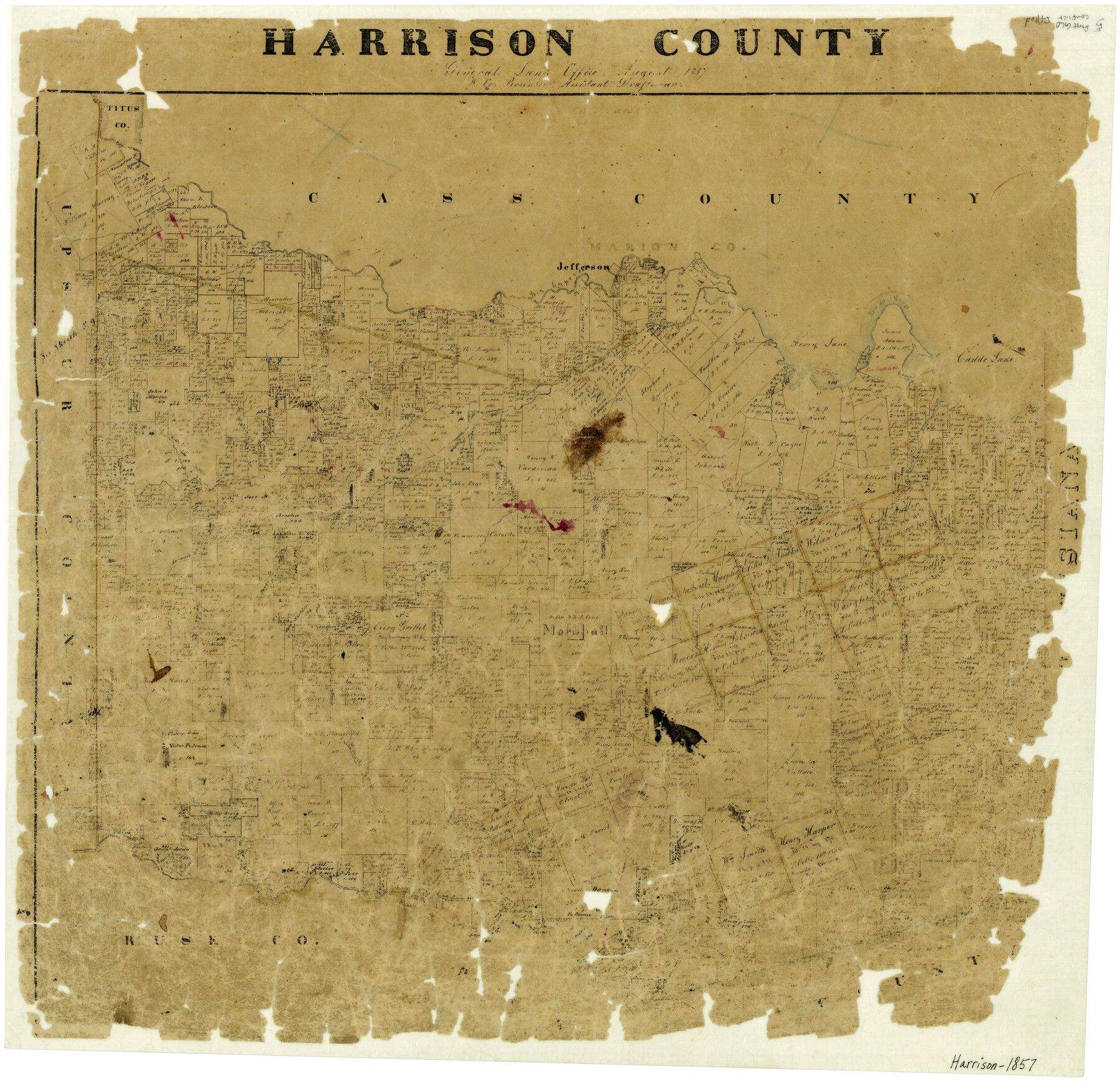
Harrison County
-
Map/Doc
1116
-
Collection
General Map Collection
-
Object Dates
8/1857 (Creation Date)
-
People and Organizations
Texas General Land Office (Publisher)
W. von Rosenberg (Draftsman)
W. von Rosenberg (Compiler)
-
Counties
Harrison
-
Subjects
County
-
Height x Width
20.3 x 21.0 inches
51.6 x 53.3 cm
-
Features
Jefferson
Sabine River
Lake Goose
Caddo Lake
Ferry Lake
Village Creek
Marshall
Hagerty's Creek
Wray's Creek
Big Cypress Creek
Nutts Creek
Big Ray's Creek
Moore Creek
Dufford's Creek
Potter's Creek
Karmer's Creek
Little Cypress Creek
Eagle Creek
Brushy Creek
Part of: General Map Collection
Brewster County Working Sketch 102

Print $20.00
- Digital $50.00
Brewster County Working Sketch 102
1980
Size 40.0 x 43.3 inches
Map/Doc 67702
Flight Mission No. CRK-3P, Frame 126, Refugio County

Print $20.00
- Digital $50.00
Flight Mission No. CRK-3P, Frame 126, Refugio County
1956
Size 18.6 x 22.4 inches
Map/Doc 86914
Red River County Working Sketch 8

Print $20.00
- Digital $50.00
Red River County Working Sketch 8
1920
Size 16.2 x 14.2 inches
Map/Doc 71991
Aransas Pass to Baffin Bay

Print $20.00
- Digital $50.00
Aransas Pass to Baffin Bay
1973
Size 42.0 x 35.1 inches
Map/Doc 73418
Flight Mission No. DCL-5C, Frame 68, Kenedy County

Print $20.00
- Digital $50.00
Flight Mission No. DCL-5C, Frame 68, Kenedy County
1943
Size 18.6 x 22.4 inches
Map/Doc 85851
Dallam County Sketch File 15

Print $18.00
- Digital $50.00
Dallam County Sketch File 15
1990
Size 14.4 x 9.0 inches
Map/Doc 20381
Sketch F No. 3 - Preliminary Chart of Key-West Harbor and Approaches

Print $20.00
- Digital $50.00
Sketch F No. 3 - Preliminary Chart of Key-West Harbor and Approaches
1852
Size 17.7 x 21.1 inches
Map/Doc 97218

Map of Matagorda Bay and County with the Adjacent Country

Print $20.00
- Digital $50.00
Map of Matagorda Bay and County with the Adjacent Country
1839
Size 33.4 x 42.6 inches
Map/Doc 2002
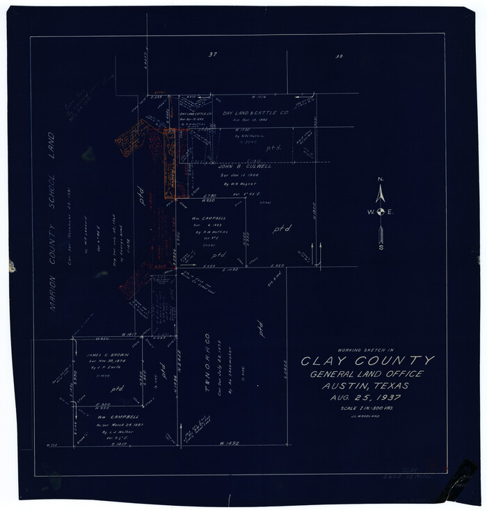
Clay County Working Sketch 8
Print $20.00
- Digital $50.00
Clay County Working Sketch 8
1937
Size 23.1 x 22.0 inches
Map/Doc 68031
Gaines County Rolled Sketch 8

Print $20.00
- Digital $50.00
Gaines County Rolled Sketch 8
Size 14.6 x 20.9 inches
Map/Doc 5928
Harris County Boundary File 39 (22)

Print $40.00
- Digital $50.00
Harris County Boundary File 39 (22)
Size 12.6 x 16.1 inches
Map/Doc 54368
You may also like
Flight Mission No. DIX-8P, Frame 84, Aransas County

Print $20.00
- Digital $50.00
Flight Mission No. DIX-8P, Frame 84, Aransas County
1956
Size 18.6 x 22.3 inches
Map/Doc 83909
Crosby County Boundary File 3

Print $2.00
- Digital $50.00
Crosby County Boundary File 3
Size 11.2 x 8.7 inches
Map/Doc 52002
Harris County Working Sketch 67

Print $20.00
- Digital $50.00
Harris County Working Sketch 67
1955
Size 23.3 x 27.5 inches
Map/Doc 65959
Roberts County Working Sketch 35

Print $20.00
- Digital $50.00
Roberts County Working Sketch 35
1978
Size 26.7 x 22.5 inches
Map/Doc 63561
Pecos County Working Sketch 89

Print $20.00
- Digital $50.00
Pecos County Working Sketch 89
1964
Size 46.5 x 34.2 inches
Map/Doc 78216
Flight Mission No. CUG-1P, Frame 112, Kleberg County

Print $20.00
- Digital $50.00
Flight Mission No. CUG-1P, Frame 112, Kleberg County
1956
Size 18.5 x 22.3 inches
Map/Doc 86162
Calhoun County Sketch File 11

Print $39.00
- Digital $50.00
Calhoun County Sketch File 11
1957
Size 11.4 x 8.9 inches
Map/Doc 35944
Galveston County

Print $40.00
- Digital $50.00
Galveston County
1939
Size 45.0 x 56.5 inches
Map/Doc 95505
Reeves County Sketch File 2

Print $26.00
- Digital $50.00
Reeves County Sketch File 2
Size 31.2 x 19.6 inches
Map/Doc 12239
Flight Mission No. CZW-1R, Frame 116, Hardeman County

Print $20.00
- Digital $50.00
Flight Mission No. CZW-1R, Frame 116, Hardeman County
1956
Size 18.6 x 19.0 inches
Map/Doc 85235
Hays County Sketch File 16

Print $4.00
- Digital $50.00
Hays County Sketch File 16
1857
Size 12.8 x 8.3 inches
Map/Doc 26227
Lamb County Sketch File 10

Print $22.00
- Digital $50.00
Lamb County Sketch File 10
1912
Size 20.0 x 31.2 inches
Map/Doc 11972