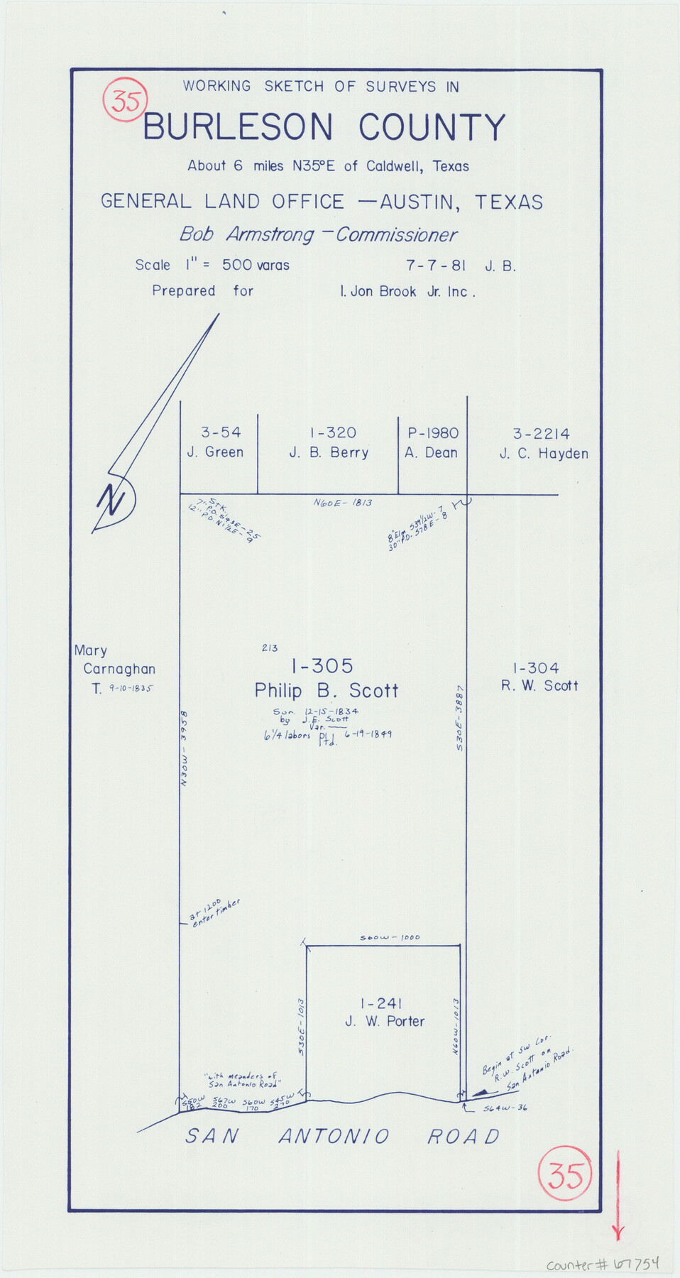
Burleson County Working Sketch 35
-
Map/Doc
67754
-
Collection
General Map Collection
-
Object Dates
7/7/1981 (Creation Date)
-
Counties
Burleson
-
Subjects
Surveying Working Sketch
-
Height x Width
16.4 x 8.7 inches
41.7 x 22.1 cm
-
Scale
1" = 500 varas
Part of: General Map Collection
Briscoe County Rolled Sketch 9

Print $20.00
- Digital $50.00
Briscoe County Rolled Sketch 9
Size 30.6 x 21.4 inches
Map/Doc 5327
Map Exhibiting the line of the Southern Trans-Continental R.R. from Marshall to Texarkana from Texarkana to Forth Worth

Print $20.00
- Digital $50.00
Map Exhibiting the line of the Southern Trans-Continental R.R. from Marshall to Texarkana from Texarkana to Forth Worth
1872
Size 24.6 x 47.8 inches
Map/Doc 64241
Presidio County Rolled Sketch 24

Print $40.00
- Digital $50.00
Presidio County Rolled Sketch 24
1886
Size 158.3 x 23.4 inches
Map/Doc 9765

Map of Bell County

Print $40.00
- Digital $50.00
Map of Bell County
1896
Size 46.7 x 53.7 inches
Map/Doc 4884
Map of portion of Galveston Bay in Chambers & Galveston Counties showing subdivision thereof for mineral development

Print $20.00
- Digital $50.00
Map of portion of Galveston Bay in Chambers & Galveston Counties showing subdivision thereof for mineral development
1938
Size 15.3 x 19.2 inches
Map/Doc 2935
Orange County Working Sketch 32

Print $20.00
- Digital $50.00
Orange County Working Sketch 32
1956
Size 22.9 x 31.7 inches
Map/Doc 71364
Gillespie County Working Sketch 2

Print $20.00
- Digital $50.00
Gillespie County Working Sketch 2
1958
Size 35.9 x 26.0 inches
Map/Doc 63165
Walker County Working Sketch 1

Print $20.00
- Digital $50.00
Walker County Working Sketch 1
1912
Size 20.1 x 18.4 inches
Map/Doc 72281
Coast Chart No. 210 Aransas Pass and Corpus Christi Bay with the coast to latitude 27° 12' Texas

Print $20.00
- Digital $50.00
Coast Chart No. 210 Aransas Pass and Corpus Christi Bay with the coast to latitude 27° 12' Texas
1887
Size 27.5 x 18.2 inches
Map/Doc 72802
Shelby County Sketch File 16 1/2

Print $4.00
- Digital $50.00
Shelby County Sketch File 16 1/2
Size 7.6 x 5.3 inches
Map/Doc 36629
Chambers County Sketch File 25

Print $8.00
- Digital $50.00
Chambers County Sketch File 25
Size 14.1 x 8.7 inches
Map/Doc 17602
You may also like
McCulloch County Sketch File 8

Print $4.00
- Digital $50.00
McCulloch County Sketch File 8
1904
Size 11.3 x 8.7 inches
Map/Doc 31182
Current Miscellaneous File 51

Print $6.00
- Digital $50.00
Current Miscellaneous File 51
Size 11.6 x 9.2 inches
Map/Doc 74029
Flight Mission No. DAG-24K, Frame 139, Matagorda County

Print $20.00
- Digital $50.00
Flight Mission No. DAG-24K, Frame 139, Matagorda County
1953
Size 18.5 x 22.3 inches
Map/Doc 86557
Castro County Sketch File 5a

Print $8.00
- Digital $50.00
Castro County Sketch File 5a
1904
Size 11.2 x 8.7 inches
Map/Doc 17491
Andrews County Sketch File 14

Print $48.00
- Digital $50.00
Andrews County Sketch File 14
1887
Size 8.0 x 8.4 inches
Map/Doc 12872
Map of Texas and part of New Mexico

Print $20.00
Map of Texas and part of New Mexico
1857
Size 17.4 x 23.1 inches
Map/Doc 95284
Stephens County Working Sketch 19

Print $40.00
- Digital $50.00
Stephens County Working Sketch 19
1969
Size 48.8 x 42.7 inches
Map/Doc 63962

Throckmorton County Rolled Sketch 6B

Print $20.00
- Digital $50.00
Throckmorton County Rolled Sketch 6B
2004
Size 20.3 x 24.2 inches
Map/Doc 82490
Brewster County Sketch File 49

Print $26.00
- Digital $50.00
Brewster County Sketch File 49
1994
Size 14.2 x 8.8 inches
Map/Doc 16329
Flight Mission No. DIX-3P, Frame 138, Aransas County

Print $20.00
- Digital $50.00
Flight Mission No. DIX-3P, Frame 138, Aransas County
1956
Size 17.7 x 18.6 inches
Map/Doc 83768
