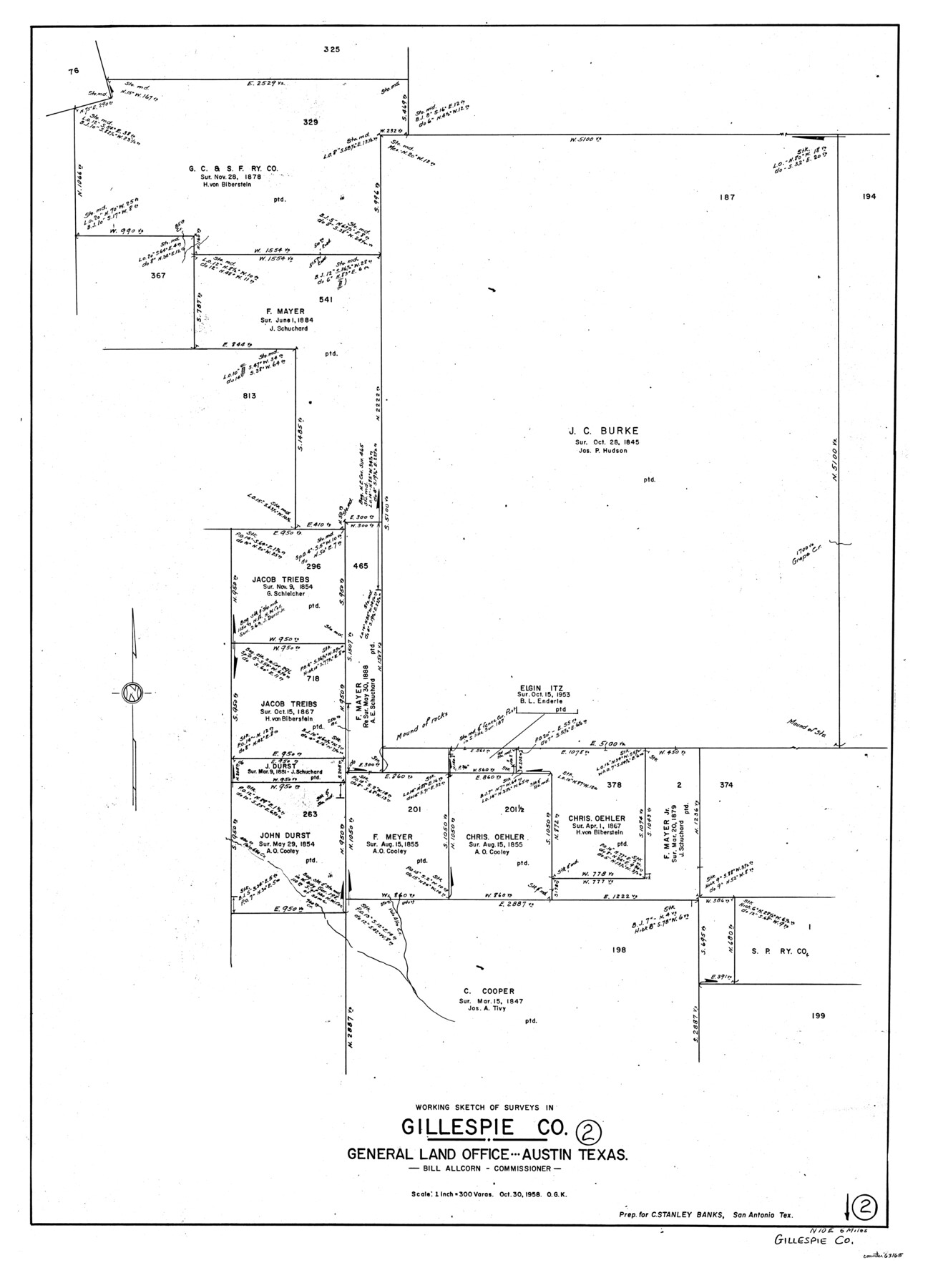
Gillespie County Working Sketch 2
-
Map/Doc
63165
-
Collection
General Map Collection
-
Object Dates
10/30/1958 (Creation Date)
-
People and Organizations
Otto G. Kurio (Draftsman)
-
Counties
Gillespie
-
Subjects
Surveying Working Sketch
-
Height x Width
35.9 x 26.0 inches
91.2 x 66.0 cm
-
Scale
1" = 300 varas
Part of: General Map Collection
Coryell County Working Sketch 16

Print $20.00
- Digital $50.00
Coryell County Working Sketch 16
1957
Size 22.0 x 21.4 inches
Map/Doc 68223
Val Verde County

Print $20.00
- Digital $50.00
Val Verde County
1944
Size 42.3 x 37.8 inches
Map/Doc 73311
[United States]
![97197, [United States], General Map Collection](https://historictexasmaps.com/wmedia_w700/maps/97197.tif.jpg)
Print $20.00
- Digital $50.00
[United States]
1848
Size 17.7 x 37.4 inches
Map/Doc 97197
Office Sketch of surveys on St. Joseph and Mustang Islands, Aransas, and Nueces Counties

Print $20.00
- Digital $50.00
Office Sketch of surveys on St. Joseph and Mustang Islands, Aransas, and Nueces Counties
1957
Size 42.6 x 18.0 inches
Map/Doc 1920
Located Line of the Panhandle & Gulf Ry. through State Lands, Public School and University, Right of Way 200 feet wide, in Brewster County, Texas.

Print $40.00
- Digital $50.00
Located Line of the Panhandle & Gulf Ry. through State Lands, Public School and University, Right of Way 200 feet wide, in Brewster County, Texas.
1904
Size 14.8 x 99.1 inches
Map/Doc 64059
Armstrong County Rolled Sketch ACP

Print $20.00
- Digital $50.00
Armstrong County Rolled Sketch ACP
1900
Size 33.0 x 35.3 inches
Map/Doc 8425
Montague County Working Sketch 8

Print $20.00
- Digital $50.00
Montague County Working Sketch 8
1928
Size 20.9 x 18.9 inches
Map/Doc 71074
Map of the Surveyed Part of Young District

Print $40.00
- Digital $50.00
Map of the Surveyed Part of Young District
1860
Size 56.3 x 27.3 inches
Map/Doc 87374
Upton County Sketch File 24

Print $4.00
- Digital $50.00
Upton County Sketch File 24
1928
Size 11.3 x 8.8 inches
Map/Doc 38879
Map of Palo Pinto County, east of the Brazos River, Robertson - west of it, Milam Land District

Print $20.00
- Digital $50.00
Map of Palo Pinto County, east of the Brazos River, Robertson - west of it, Milam Land District
1859
Size 27.4 x 22.3 inches
Map/Doc 3935
Gulf of Mexico

Print $20.00
- Digital $50.00
Gulf of Mexico
1905
Size 18.3 x 26.8 inches
Map/Doc 72653
Hood County Working Sketch 15

Print $20.00
- Digital $50.00
Hood County Working Sketch 15
1985
Size 30.0 x 28.2 inches
Map/Doc 66209
You may also like
Map of the Republic of Mexico

Print $20.00
Map of the Republic of Mexico
1882
Size 33.0 x 47.4 inches
Map/Doc 76220
Atascosa County Working Sketch 2

Print $20.00
- Digital $50.00
Atascosa County Working Sketch 2
1910
Size 23.5 x 33.2 inches
Map/Doc 67197
Crockett County Rolled Sketch 26

Print $20.00
- Digital $50.00
Crockett County Rolled Sketch 26
Size 33.7 x 40.9 inches
Map/Doc 5585
Flight Mission No. DIX-3P, Frame 59, Aransas County

Print $20.00
- Digital $50.00
Flight Mission No. DIX-3P, Frame 59, Aransas County
1956
Size 17.6 x 21.1 inches
Map/Doc 83761
Gulf, Texas & Western Railway

Print $40.00
- Digital $50.00
Gulf, Texas & Western Railway
1913
Size 19.8 x 64.7 inches
Map/Doc 64441

Jeff Davis County Sketch File 25b

Print $20.00
- Digital $50.00
Jeff Davis County Sketch File 25b
Size 18.9 x 20.0 inches
Map/Doc 11861
Atascosa County Sketch File 27a

Print $4.00
- Digital $50.00
Atascosa County Sketch File 27a
Size 8.4 x 14.3 inches
Map/Doc 13799
Webb County Sketch File 7-2

Print $20.00
- Digital $50.00
Webb County Sketch File 7-2
1927
Size 31.6 x 23.7 inches
Map/Doc 12618
Runnels County Working Sketch 19

Print $20.00
- Digital $50.00
Runnels County Working Sketch 19
1950
Size 24.9 x 30.8 inches
Map/Doc 63615
Montgomery County Working Sketch 29

Print $20.00
- Digital $50.00
Montgomery County Working Sketch 29
1942
Size 32.3 x 33.9 inches
Map/Doc 71136
