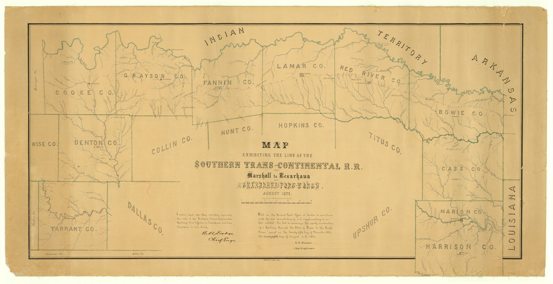
Map Exhibiting the line of the Southern Trans-Continental R.R. from Marshall to Texarkana from Texarkana to Forth Worth
Z-2-59
-
Map/Doc
64241
-
Collection
General Map Collection
-
Object Dates
1872 (Creation Date)
1872/8/28 (File Date)
-
People and Organizations
Theo. C. Link (Draftsman)
G.M. Dodge (Surveyor/Engineer)
C.C. Stremme (GLO Clerk)
-
Counties
Hunt Tarrant Dallas Upshur Harrison Marion Cass Titus Hopkins Cooke Collin Denton Wise Bowie Red River Lamar Fannin Grayson
-
Subjects
Railroads
-
Height x Width
24.6 x 47.8 inches
62.5 x 121.4 cm
-
Medium
paper, manuscript
-
Scale
5 miles = 1 inch
-
Features
STC
Marysville
Gainsville
Preston
Shawneetown
Sherman
White Mound
Kentuckytown
Pilot Grove
Pilot Point
Denton
Alton
Fort Worth
Mountain Creek
Camp Creek
Fish Creek
Red River
Pecan Creek
Brown's Creek
Clear Creek
Finley's Creek
Gray's Creek
Spring Creek
Wolf Creek
Indian Creek
Cross Timber Creek
Isle au Bois Creek
Duck Creek
Big Elm Creek
Pecan Creek
Hickory Creek
Timber Creek
Brook's Creek
Oliver's Creek
Trail Creek
Harriet's Creek
Henrietta's Creek
Elizabeth's Creek
Denton Fork of Trinity River
Indian Creek
Stewart's Creek
Panther Creek
Little Elm Creek
Pecan Creek
Mustang Creek
Wild Creek
Bear Creek
Little Bear Creek
Fossil Creek
Little Fossil Creek
West Fork of Trinity River
Clear Fork of Trinity River
Cedar Creek
Big Mineral Creek
Brushy Creek
Sandy Creek
Little Sandy Creek
Little Mineral Creek
Shawnee Creek
Duck Creek
Paw Paw Creek
Shortstone Bluffs
Jordan Creek
Salt Creek
Hatcher's Creek
Goospond Creek
Range Creek
Mormon Fork
Strickland's Creek
Buck Creek
Mustang Fork
Elbow Creek
Bill Deaver's Fork
Dry Fork
Rt. Hand Fork
Elm Fork
Pecan Creek
Iron Ore Creek
Clear Creek
Smith's Creek
Choctaw Bayou
Shannon's Creek
Cornelius' Creek
Mill Creek
Rattlesnake Creek
Little Cedar Creek
Wild Creek
East Fork of Trinity River
Squirrel Fork
White's Creek
Sister Grove Creek
Porter Fork
Simmon's Creek
Pilot Grove Creek
Brushy Creek
Caney Creek
Sowell's Creek
Bois D'Arc Creek
Coffee Mill Creek
Wood Creek
Honey Grove Creek
Timber Creek
Powder Creek
Blanton Creek
Brushy Creek
Jones' Creek
McCung's Creek
Davis' Creek
Big Indian Creek
Indian Creek
Dan Lee's Creek
Sloan's Creek
Bullard's Creek
Merced's Creek
South Sulpher
Middle Sulpher
Bonham
Honey Grove
Paris
Starkesville
Sanders Creek
Cottonwood Creek
3 Mile Creek
Pine Creek
Noble's Creek
Cane Creek
Rock Creek
Honey Creek
Allen's Creek
Crocket's Creek
Odd's Creek
Hickory Creek
Big Sandy Creek
Little Sandy Creek
Mulberry Creek
Little Brushy Creek
Ward's Creek
North Sulpher
Robbinsville
Clarksville
Savannah
Slingland Lake
Lower Pine Creek
Little Pine Creek
Atkinson Lake
Bason's Mill Creek
North Fork of Pecan Bayou
Pecan Bayou
White Oak Fork of Pecan Bayou
South Fork of Pecan Bayou
Wild Oat Creek
Dean's Creek
Harrison's Creek
Coal Creek
Burton Creek
Boggy Creek
Langford's Creek
Duty Creek
Jack's Creek
Lawson Creek
Kickapoo Creek
White Oak Creek
Mill Creek
Anderson's Creek
Mustang Creek
Little Mustang Creek
Little White Oak Creek
Big Caney Creek
Culp's Ferry
Little Creek
Young's Creek
Mud Creek
DeKalb
Sulpher River
Booth's Creek
Blythe Creek
Ward's Creek
Weaver's Creek
Brook's Creek
Red Bayou
Mill Bayou
McKinney's Creek
Boston
Texarkana
Hurricane Creek
Day Creek
Moore's Landing
Herring's Creek
Elliot's Creek
Langham's Creek
Brown's Creek
Shed Creek
Baker's Creek
Douglasville
Turkey Creek
Kelley's Creek
Black Cypress River
Flat Creek
Mill Creek
Frazier Bayou
John's Creek
Plat Creek
Frazier Creek
Haw Creek
Muddy Creek
Black Bayou
Beech Creek
Jim's Bayou
Wilburn Creek
Bear Creek
Linden
Allen's Creek
Nutt's Creek
Johnson's Creek
Big Cypress River
Kitchen's Creek
Little Cypress
Morris' Creek
Wray's Creek
Hagerty's Creek
Village Creek
Sabine River
Mason's Creek
Dufford's Creek
Potter's Creek
Caddo Creek
Eight Mile Creek
Marshall
Jefferson
Ferry Lake
Caddo Lake
Part of: General Map Collection
Pecos County Working Sketch 62

Print $40.00
- Digital $50.00
Pecos County Working Sketch 62
1952
Size 32.3 x 59.1 inches
Map/Doc 71534
Irion County Boundary File 3

Print $38.00
- Digital $50.00
Irion County Boundary File 3
Size 8.8 x 4.2 inches
Map/Doc 55339
Lampasas County Sketch File 21

Print $14.00
- Digital $50.00
Lampasas County Sketch File 21
2001
Size 14.2 x 8.8 inches
Map/Doc 29436
Lampasas County Working Sketch 13

Print $20.00
- Digital $50.00
Lampasas County Working Sketch 13
1973
Size 34.4 x 27.7 inches
Map/Doc 70290
Williamson County Boundary File 1a

Print $4.00
- Digital $50.00
Williamson County Boundary File 1a
Size 11.0 x 8.4 inches
Map/Doc 59990
Pecos County Working Sketch 90

Print $40.00
- Digital $50.00
Pecos County Working Sketch 90
1964
Size 65.3 x 26.6 inches
Map/Doc 71562
Midland County Rolled Sketch 1

Print $20.00
- Digital $50.00
Midland County Rolled Sketch 1
1940
Size 32.9 x 35.0 inches
Map/Doc 9512
Reagan County Working Sketch 13

Print $40.00
- Digital $50.00
Reagan County Working Sketch 13
1948
Size 23.8 x 50.8 inches
Map/Doc 71853
Concho County Rolled Sketch 27

Print $20.00
- Digital $50.00
Concho County Rolled Sketch 27
2002
Size 30.5 x 40.5 inches
Map/Doc 78514
Jack County Working Sketch 3

Print $20.00
- Digital $50.00
Jack County Working Sketch 3
1940
Size 18.8 x 26.0 inches
Map/Doc 66429
Tom Green County Sketch File XXX

Print $20.00
- Digital $50.00
Tom Green County Sketch File XXX
Size 17.0 x 20.5 inches
Map/Doc 12457
Upton County Sketch File 37

Print $6.00
- Digital $50.00
Upton County Sketch File 37
1953
Size 11.3 x 8.8 inches
Map/Doc 38900
You may also like
Surveys made on La Parita, March 1847

Print $2.00
- Digital $50.00
Surveys made on La Parita, March 1847
1847
Size 10.1 x 7.5 inches
Map/Doc 222

Flight Mission No. CUG-2P, Frame 26, Kleberg County

Print $20.00
- Digital $50.00
Flight Mission No. CUG-2P, Frame 26, Kleberg County
1956
Size 18.7 x 22.4 inches
Map/Doc 86190
Pecos County Sketch File 1A

Print $20.00
- Digital $50.00
Pecos County Sketch File 1A
1919
Size 34.3 x 23.7 inches
Map/Doc 12155
Hood County Working Sketch 20

Print $20.00
- Digital $50.00
Hood County Working Sketch 20
1989
Size 39.6 x 34.7 inches
Map/Doc 66214
Limestone County Sketch File 10

Print $4.00
- Digital $50.00
Limestone County Sketch File 10
Size 8.4 x 9.4 inches
Map/Doc 30171
Rusk County Sketch File 44

Print $12.00
Rusk County Sketch File 44
1951
Size 11.3 x 8.9 inches
Map/Doc 35585
Jefferson County Sketch File 47

Print $20.00
- Digital $50.00
Jefferson County Sketch File 47
1898
Size 27.2 x 19.1 inches
Map/Doc 11881
[Map showing connecting line from New Mexico to Double Lakes]
![91998, [Map showing connecting line from New Mexico to Double Lakes], Twichell Survey Records](https://historictexasmaps.com/wmedia_w700/maps/91998-1.tif.jpg)
Print $20.00
- Digital $50.00
[Map showing connecting line from New Mexico to Double Lakes]
1913
Size 39.6 x 24.2 inches
Map/Doc 91998
Dallas County Working Sketch 13

Print $20.00
- Digital $50.00
Dallas County Working Sketch 13
1984
Size 27.9 x 32.6 inches
Map/Doc 68579
Moore County Rolled Sketch 11

Print $20.00
- Digital $50.00
Moore County Rolled Sketch 11
Size 34.1 x 43.0 inches
Map/Doc 9549
Zapata County Working Sketch 14

Print $20.00
- Digital $50.00
Zapata County Working Sketch 14
1962
Size 44.5 x 40.4 inches
Map/Doc 62065