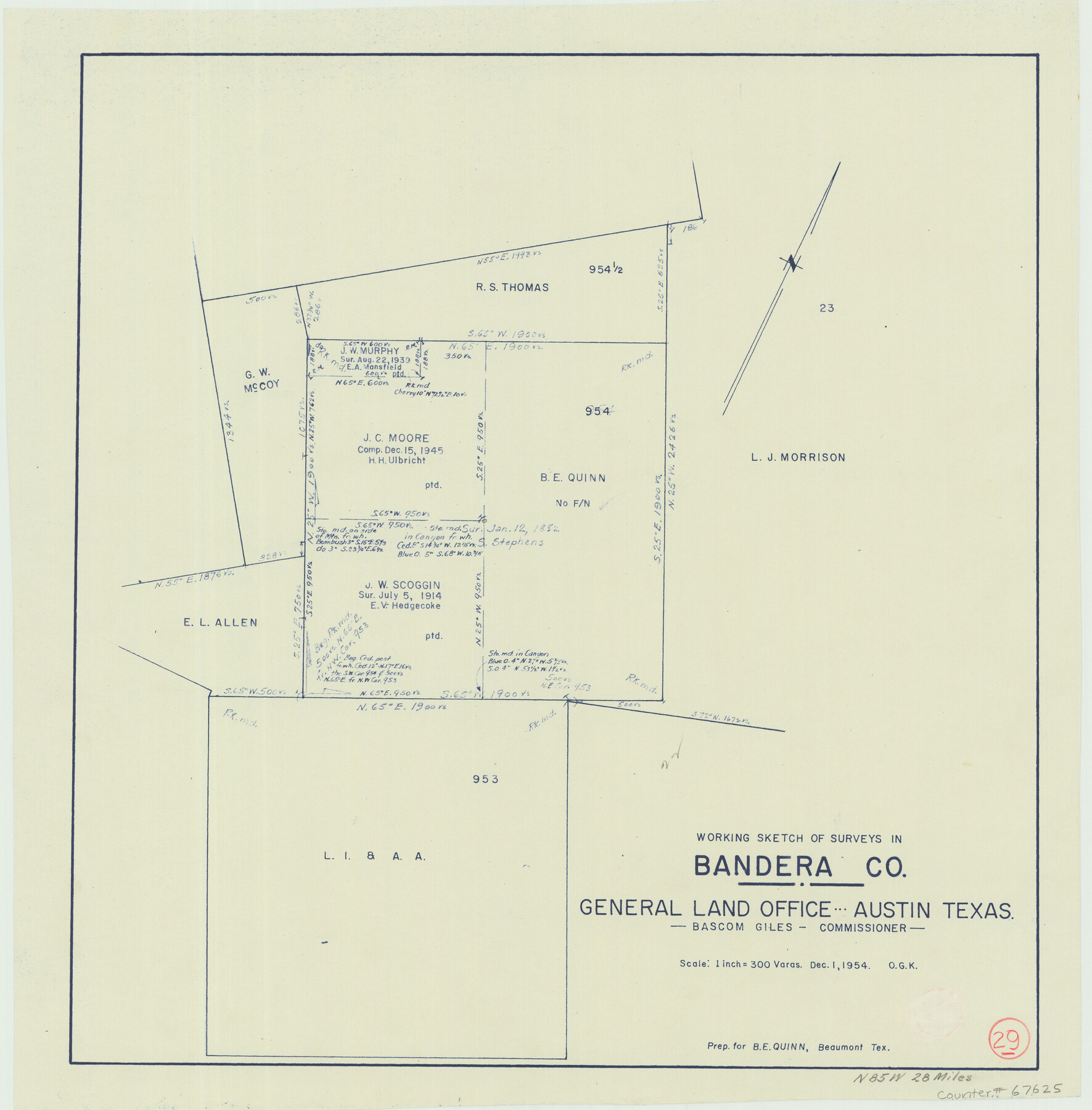
Bandera County Working Sketch 29
-
Map/Doc
67625
-
Collection
General Map Collection
-
Object Dates
12/1/1954 (Creation Date)
-
People and Organizations
Bascom Giles (GLO Commissioner)
Otto G. Kurio (Draftsman)
-
Counties
Bandera
-
Subjects
Surveying Working Sketch
-
Height x Width
19.6 x 19.3 inches
49.8 x 49.0 cm
-
Scale
1" = 300 varas
-
Comments
Surveys located about 28 miles North 85 degrees West of Bandera, Texas.
Part of: General Map Collection
[Gulf Coast of Texas]
![72705, [Gulf Coast of Texas], General Map Collection](https://historictexasmaps.com/wmedia_w700/maps/72705.tif.jpg)
Print $20.00
- Digital $50.00
[Gulf Coast of Texas]
1881
Size 28.7 x 18.2 inches
Map/Doc 72705
Newton County Working Sketch 42

Print $20.00
- Digital $50.00
Newton County Working Sketch 42
1981
Size 26.4 x 22.5 inches
Map/Doc 71288
Upshur County Working Sketch 7

Print $40.00
- Digital $50.00
Upshur County Working Sketch 7
1953
Size 49.0 x 43.1 inches
Map/Doc 69563
Cameron County Rolled Sketch 23

Print $17.00
- Digital $50.00
Cameron County Rolled Sketch 23
Size 10.0 x 15.2 inches
Map/Doc 43931
Hidalgo County Rolled Sketch 9

Print $20.00
- Digital $50.00
Hidalgo County Rolled Sketch 9
1906
Size 18.9 x 24.8 inches
Map/Doc 6210
Cass County Working Sketch 36

Print $20.00
- Digital $50.00
Cass County Working Sketch 36
1982
Size 37.9 x 39.4 inches
Map/Doc 67939
Ellis County Boundary File 4

Print $14.00
- Digital $50.00
Ellis County Boundary File 4
Size 14.2 x 8.6 inches
Map/Doc 52983
Liberty County Working Sketch 49a

Print $20.00
- Digital $50.00
Liberty County Working Sketch 49a
1955
Size 32.7 x 39.9 inches
Map/Doc 70508
Freestone County Working Sketch 7

Print $20.00
- Digital $50.00
Freestone County Working Sketch 7
1951
Size 32.8 x 24.4 inches
Map/Doc 69249
Controlled Mosaic by Jack Amman Photogrammetric Engineers, Inc - Sheet 20

Print $20.00
- Digital $50.00
Controlled Mosaic by Jack Amman Photogrammetric Engineers, Inc - Sheet 20
1954
Size 20.0 x 24.0 inches
Map/Doc 83467
Presidio County Rolled Sketch 131A

Print $20.00
- Digital $50.00
Presidio County Rolled Sketch 131A
1992
Size 36.5 x 46.7 inches
Map/Doc 9802
Brewster County Working Sketch 89

Print $20.00
- Digital $50.00
Brewster County Working Sketch 89
1974
Size 20.5 x 44.1 inches
Map/Doc 67689
You may also like
Live Oak County Working Sketch 10

Print $20.00
- Digital $50.00
Live Oak County Working Sketch 10
1946
Size 36.2 x 41.8 inches
Map/Doc 70595
El Paso County Working Sketch 39

Print $20.00
- Digital $50.00
El Paso County Working Sketch 39
1984
Size 45.7 x 37.1 inches
Map/Doc 69061
Kenedy County Rolled Sketch 3

Print $40.00
- Digital $50.00
Kenedy County Rolled Sketch 3
1904
Size 40.1 x 57.4 inches
Map/Doc 9329
[Sketch showing Blocks C-11, C-13, C-14, C-16, C-10]
![93123, [Sketch showing Blocks C-11, C-13, C-14, C-16, C-10], Twichell Survey Records](https://historictexasmaps.com/wmedia_w700/maps/93123-1.tif.jpg)
Print $40.00
- Digital $50.00
[Sketch showing Blocks C-11, C-13, C-14, C-16, C-10]
Size 69.9 x 22.5 inches
Map/Doc 93123
Duval County Sketch File 47

Print $6.00
- Digital $50.00
Duval County Sketch File 47
Size 11.5 x 8.8 inches
Map/Doc 21402
University of Texas System University Lands

Print $20.00
- Digital $50.00
University of Texas System University Lands
1931
Size 23.2 x 17.5 inches
Map/Doc 93241
General Highway Map, Webb County, Texas

Print $20.00
General Highway Map, Webb County, Texas
1961
Size 18.2 x 24.8 inches
Map/Doc 79704
Flight Mission No. BQR-16K, Frame 34, Brazoria County

Print $20.00
- Digital $50.00
Flight Mission No. BQR-16K, Frame 34, Brazoria County
1952
Size 18.7 x 22.4 inches
Map/Doc 84101
Flight Mission No. DIX-5P, Frame 102, Aransas County

Print $20.00
- Digital $50.00
Flight Mission No. DIX-5P, Frame 102, Aransas County
1956
Size 17.7 x 18.0 inches
Map/Doc 83780
Colorado County Working Sketch 5

Print $40.00
- Digital $50.00
Colorado County Working Sketch 5
1919
Size 82.4 x 44.1 inches
Map/Doc 68105
Foard County Sketch File 29

Print $20.00
- Digital $50.00
Foard County Sketch File 29
Size 18.9 x 29.4 inches
Map/Doc 11494
Intracoastal Waterway - Galveston Bay to West Bay including Galveston Bay Entrance

Print $20.00
- Digital $50.00
Intracoastal Waterway - Galveston Bay to West Bay including Galveston Bay Entrance
1957
Size 27.2 x 38.6 inches
Map/Doc 69933