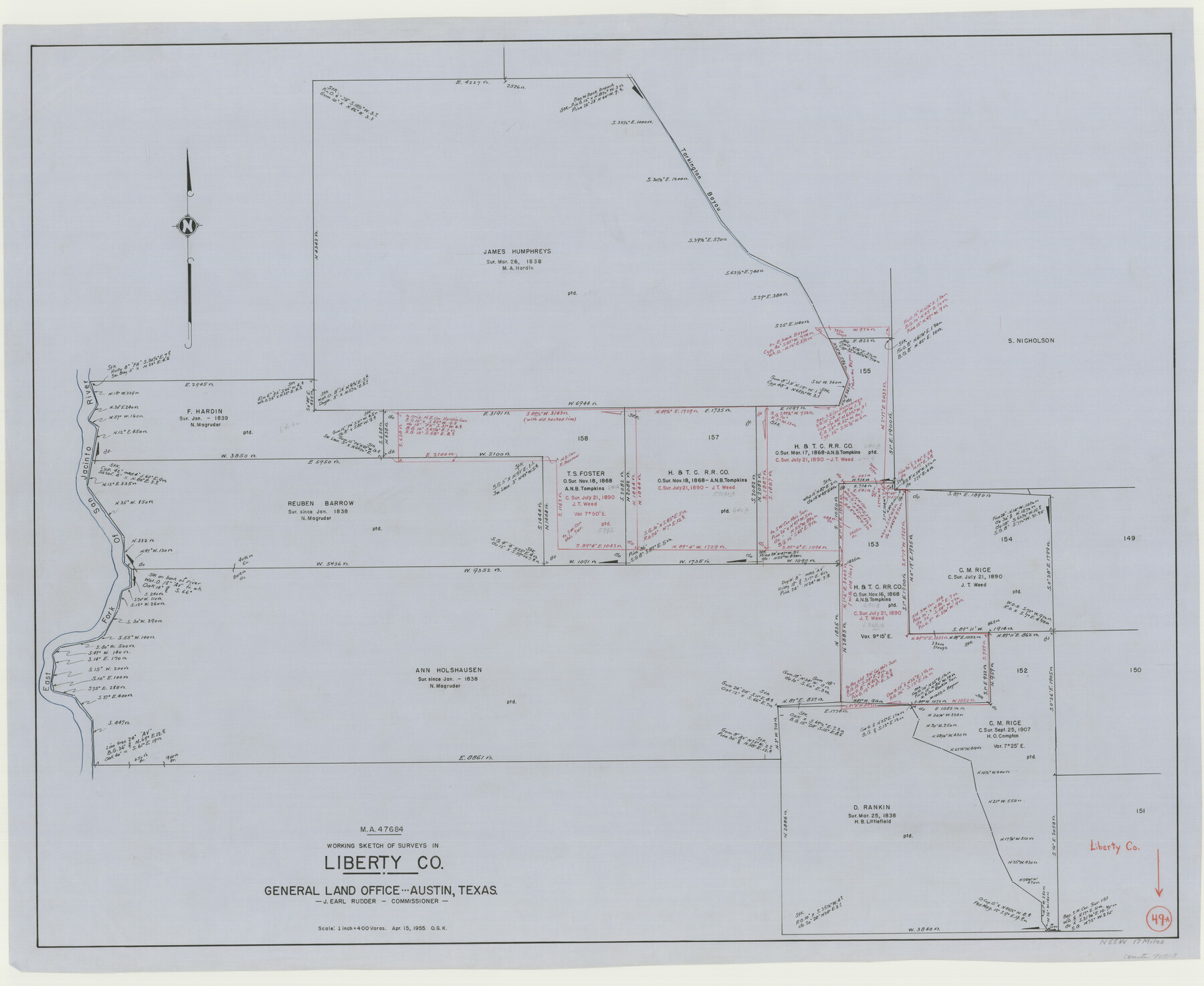
Liberty County Working Sketch 49a
-
Map/Doc
70508
-
Collection
General Map Collection
-
Object Dates
4/15/1955 (Creation Date)
-
People and Organizations
Otto G. Kurio (Draftsman)
-
Counties
Liberty
-
Subjects
Surveying Working Sketch
-
Height x Width
32.7 x 39.9 inches
83.1 x 101.4 cm
-
Scale
1" = 400 varas
Part of: General Map Collection
[Sketch from Burnet Co. to Baylor Co. tying center of counties to county site]
![1699, [Sketch from Burnet Co. to Baylor Co. tying center of counties to county site], General Map Collection](https://historictexasmaps.com/wmedia_w700/maps/1699.tif.jpg)
Print $40.00
- Digital $50.00
[Sketch from Burnet Co. to Baylor Co. tying center of counties to county site]
1900
Size 132.6 x 31.9 inches
Map/Doc 1699
[Missouri, Kansas & Texas Line Map through Bastrop County]
![64033, [Missouri, Kansas & Texas Line Map through Bastrop County], General Map Collection](https://historictexasmaps.com/wmedia_w700/maps/64033.tif.jpg)
Print $40.00
- Digital $50.00
[Missouri, Kansas & Texas Line Map through Bastrop County]
1916
Size 25.2 x 68.9 inches
Map/Doc 64033
Grayson County Sketch File 4

Print $4.00
- Digital $50.00
Grayson County Sketch File 4
1856
Size 12.5 x 8.2 inches
Map/Doc 24462
Dickens County Rolled Sketch 7
Print $20.00
- Digital $50.00
Dickens County Rolled Sketch 7
1947
Size 33.6 x 23.6 inches
Map/Doc 5706
Robertson County Rolled Sketch 5

Print $20.00
- Digital $50.00
Robertson County Rolled Sketch 5
1976
Size 34.1 x 36.4 inches
Map/Doc 9864
Brooks County Rolled Sketch 26

Print $20.00
- Digital $50.00
Brooks County Rolled Sketch 26
1945
Size 33.7 x 43.3 inches
Map/Doc 8539
Young County Sketch File 10a

Print $4.00
- Digital $50.00
Young County Sketch File 10a
1879
Size 8.0 x 7.5 inches
Map/Doc 40868
Hudspeth County Working Sketch 21

Print $20.00
- Digital $50.00
Hudspeth County Working Sketch 21
1966
Size 22.8 x 41.6 inches
Map/Doc 66303
Briscoe County Sketch File 5

Print $40.00
- Digital $50.00
Briscoe County Sketch File 5
Size 29.8 x 26.5 inches
Map/Doc 10994
Cottle County

Print $20.00
- Digital $50.00
Cottle County
1971
Size 43.4 x 36.0 inches
Map/Doc 95467
Brazoria County NRC Article 33.136 Sketch 15

Print $44.00
- Digital $50.00
Brazoria County NRC Article 33.136 Sketch 15
2014
Size 39.8 x 30.0 inches
Map/Doc 94698
Potter County Boundary File 6

Print $24.00
- Digital $50.00
Potter County Boundary File 6
Size 14.8 x 9.2 inches
Map/Doc 58027
You may also like
Upton County Rolled Sketch 21

Print $20.00
- Digital $50.00
Upton County Rolled Sketch 21
1939
Size 21.5 x 37.9 inches
Map/Doc 8072
Map of Blue Creek Ranch in Moore County, Texas

Print $20.00
- Digital $50.00
Map of Blue Creek Ranch in Moore County, Texas
Size 15.1 x 13.8 inches
Map/Doc 91420
Outer Continental Shelf Leasing Maps (Louisiana Offshore Operations)

Print $20.00
- Digital $50.00
Outer Continental Shelf Leasing Maps (Louisiana Offshore Operations)
1954
Size 11.3 x 12.4 inches
Map/Doc 76117
Kimble County Working Sketch 41

Print $20.00
- Digital $50.00
Kimble County Working Sketch 41
1948
Size 36.1 x 33.2 inches
Map/Doc 70109
Bosque County Working Sketch 16

Print $20.00
- Digital $50.00
Bosque County Working Sketch 16
1974
Size 40.5 x 33.2 inches
Map/Doc 67449
Flight Mission No. BRA-7M, Frame 30, Jefferson County

Print $20.00
- Digital $50.00
Flight Mission No. BRA-7M, Frame 30, Jefferson County
1953
Size 18.6 x 22.3 inches
Map/Doc 85481
Kinney County Rolled Sketch 1

Print $20.00
- Digital $50.00
Kinney County Rolled Sketch 1
Size 25.1 x 36.1 inches
Map/Doc 6533
Duval County Sketch File 4d

Print $4.00
- Digital $50.00
Duval County Sketch File 4d
1874
Size 10.8 x 8.7 inches
Map/Doc 21288
Llano County Working Sketch 8

Print $20.00
- Digital $50.00
Llano County Working Sketch 8
1978
Size 33.4 x 30.7 inches
Map/Doc 70626
Map of Texas with population and location of principal towns and cities, according to latest reliable statistics

Print $20.00
- Digital $50.00
Map of Texas with population and location of principal towns and cities, according to latest reliable statistics
1906
Size 18.9 x 22.4 inches
Map/Doc 95869
Lamb County Boundary File 1b

Print $2.00
- Digital $50.00
Lamb County Boundary File 1b
Size 10.9 x 8.8 inches
Map/Doc 56044
Jeff Davis County Boundary File 1a

Print $8.00
- Digital $50.00
Jeff Davis County Boundary File 1a
Size 14.3 x 8.8 inches
Map/Doc 55501