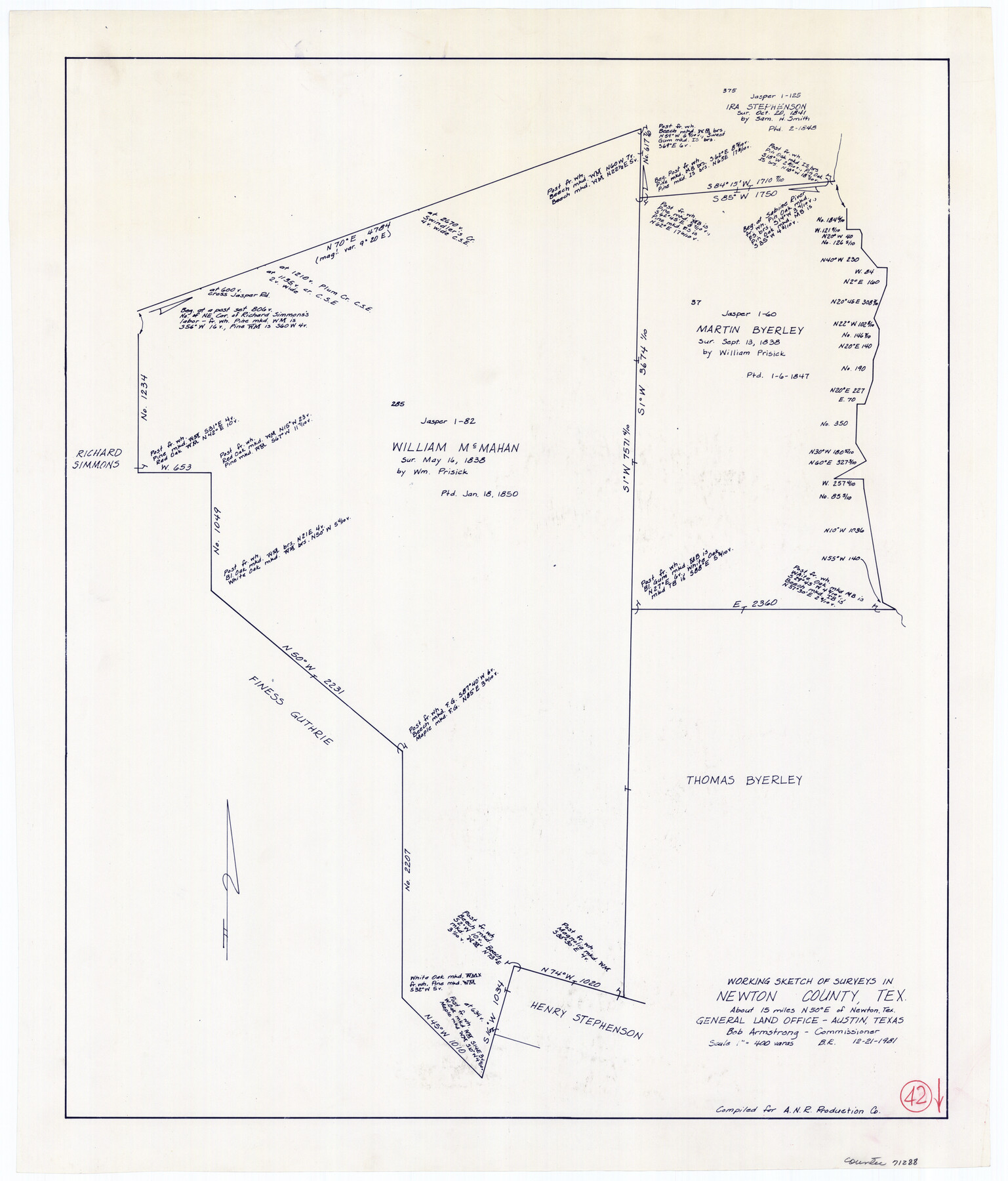
Newton County Working Sketch 42
-
Map/Doc
71288
-
Collection
General Map Collection
-
Object Dates
12/21/1981 (Creation Date)
-
People and Organizations
Beverly Robison (Draftsman)
-
Counties
Newton
-
Subjects
Surveying Working Sketch
-
Height x Width
26.4 x 22.5 inches
67.1 x 57.2 cm
-
Scale
1" = 400 varas
Part of: General Map Collection
Mitchell County Working Sketch 6

Print $20.00
- Digital $50.00
Mitchell County Working Sketch 6
1960
Size 26.1 x 22.6 inches
Map/Doc 71063
2008 Official Travel Map Texas

Digital $50.00
2008 Official Travel Map Texas
Size 33.4 x 36.5 inches
Map/Doc 94310
Reeves County Working Sketch 39

Print $40.00
- Digital $50.00
Reeves County Working Sketch 39
1971
Size 60.9 x 36.2 inches
Map/Doc 63482
Liberty County Sketch File 17

Print $2.00
- Digital $50.00
Liberty County Sketch File 17
Size 8.2 x 3.2 inches
Map/Doc 29919
Atascosa County Rolled Sketch 17

Print $20.00
- Digital $50.00
Atascosa County Rolled Sketch 17
1953
Size 35.6 x 28.2 inches
Map/Doc 5097
Trinity River, South Extension Porters Bluff Sheet

Print $20.00
- Digital $50.00
Trinity River, South Extension Porters Bluff Sheet
1925
Size 16.3 x 24.4 inches
Map/Doc 69690
Hudspeth County Rolled Sketch 66

Print $20.00
- Digital $50.00
Hudspeth County Rolled Sketch 66
1973
Size 11.7 x 18.2 inches
Map/Doc 6263
Erath County Working Sketch 17

Print $20.00
- Digital $50.00
Erath County Working Sketch 17
1962
Size 20.4 x 23.1 inches
Map/Doc 69098
Sutton County Working Sketch 29

Print $20.00
- Digital $50.00
Sutton County Working Sketch 29
1917
Size 15.8 x 13.6 inches
Map/Doc 62372
Crockett County Working Sketch 70

Print $40.00
- Digital $50.00
Crockett County Working Sketch 70
1963
Size 23.7 x 49.5 inches
Map/Doc 68403
Austin County Sketch File A

Print $40.00
- Digital $50.00
Austin County Sketch File A
1895
Size 22.3 x 21.1 inches
Map/Doc 10878
Culberson County Sketch File 10a

Print $20.00
- Digital $50.00
Culberson County Sketch File 10a
1926
Size 11.9 x 18.3 inches
Map/Doc 11264
You may also like
Victoria County Sketch File 6

Print $2.00
- Digital $50.00
Victoria County Sketch File 6
Size 5.3 x 12.5 inches
Map/Doc 39523
Throckmorton County Sketch File 13

Print $20.00
- Digital $50.00
Throckmorton County Sketch File 13
1994
Size 11.3 x 9.1 inches
Map/Doc 38120
Nueces County Sketch File 24

Print $2.00
- Digital $50.00
Nueces County Sketch File 24
Size 8.7 x 14.0 inches
Map/Doc 32571
Tarrant County Boundary File 82

Print $22.00
- Digital $50.00
Tarrant County Boundary File 82
Size 8.9 x 7.0 inches
Map/Doc 59173
Angelina County Working Sketch 38

Print $20.00
- Digital $50.00
Angelina County Working Sketch 38
1958
Size 26.4 x 33.0 inches
Map/Doc 67121
Aransas County Rolled Sketch 2

Print $40.00
- Digital $50.00
Aransas County Rolled Sketch 2
1950
Size 54.7 x 50.5 inches
Map/Doc 73612
Tarrant County Sketch File 2

Print $4.00
- Digital $50.00
Tarrant County Sketch File 2
1857
Size 7.0 x 6.5 inches
Map/Doc 37674
Rains County Rolled Sketch 2

Print $41.00
- Digital $50.00
Rains County Rolled Sketch 2
1958
Size 10.4 x 15.4 inches
Map/Doc 48829
Flight Mission No. CRK-5P, Frame 160, Refugio County

Print $20.00
- Digital $50.00
Flight Mission No. CRK-5P, Frame 160, Refugio County
1956
Size 18.6 x 22.4 inches
Map/Doc 86941
Section E Tech Memorial Park, Inc.

Print $20.00
- Digital $50.00
Section E Tech Memorial Park, Inc.
Size 30.9 x 19.1 inches
Map/Doc 92301
Map of Harris County

Print $40.00
- Digital $50.00
Map of Harris County
1897
Size 48.4 x 66.9 inches
Map/Doc 82068
Johnson County Working Sketch 30

Print $20.00
- Digital $50.00
Johnson County Working Sketch 30
2007
Size 40.9 x 42.0 inches
Map/Doc 83807