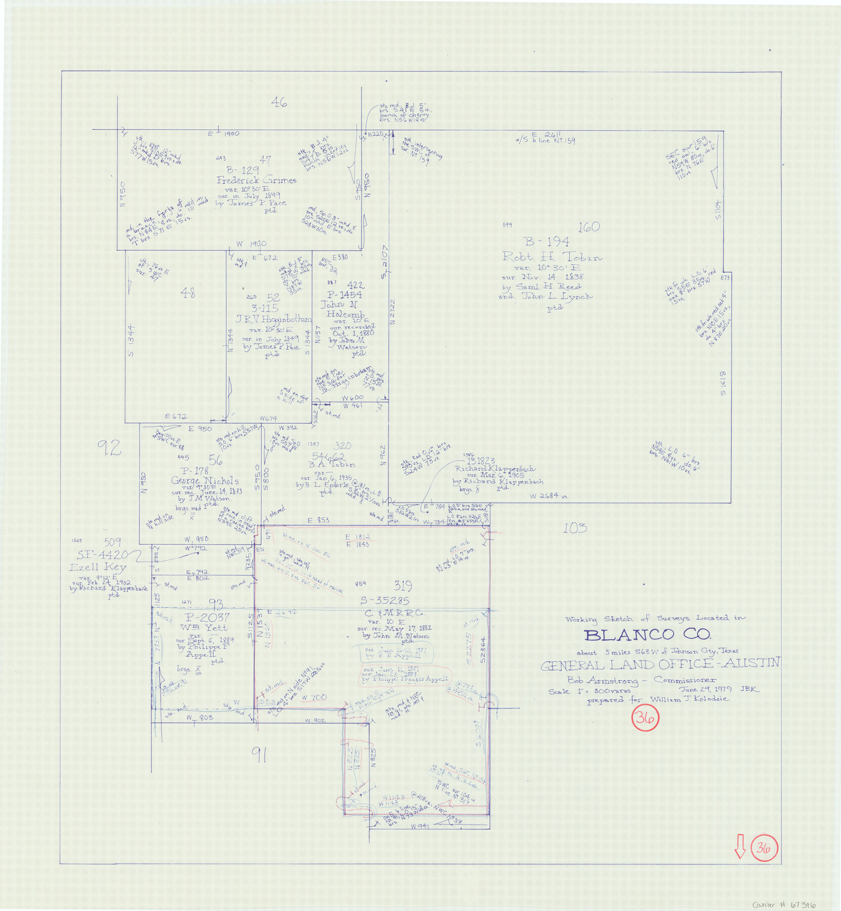
Blanco County Working Sketch 36
-
Map/Doc
67396
-
Collection
General Map Collection
-
Object Dates
6/29/1979 (Creation Date)
-
People and Organizations
Bob Armstrong (GLO Commissioner)
Joan Kilpatrick (Draftsman)
-
Counties
Blanco
-
Subjects
Surveying Working Sketch
-
Height x Width
23.8 x 22.0 inches
60.5 x 55.9 cm
-
Scale
1" = 300 varas
-
Comments
Surveys located about five miles South 63 degrees West of Johnson City, Texas.
Part of: General Map Collection
[Tom Green County]
![16901, [Tom Green County], General Map Collection](https://historictexasmaps.com/wmedia_w700/maps/16901.tif.jpg)
Print $20.00
- Digital $50.00
[Tom Green County]
1888
Size 33.2 x 34.4 inches
Map/Doc 16901
[F. W. & D. C. Ry. Co. Alignment and Right of Way Map, Clay County]
![64739, [F. W. & D. C. Ry. Co. Alignment and Right of Way Map, Clay County], General Map Collection](https://historictexasmaps.com/wmedia_w700/maps/64739-GC.tif.jpg)
Print $20.00
- Digital $50.00
[F. W. & D. C. Ry. Co. Alignment and Right of Way Map, Clay County]
1927
Size 18.6 x 11.7 inches
Map/Doc 64739
Castro County Rolled Sketch 12

Print $20.00
- Digital $50.00
Castro County Rolled Sketch 12
1945
Size 25.7 x 15.8 inches
Map/Doc 5421
Irion County Sketch File 4

Print $12.00
- Digital $50.00
Irion County Sketch File 4
1900
Size 13.7 x 8.8 inches
Map/Doc 27457
Burnet County Sketch File 8

Print $22.00
- Digital $50.00
Burnet County Sketch File 8
Size 8.1 x 6.3 inches
Map/Doc 16689
Travis County

Print $20.00
- Digital $50.00
Travis County
1895
Size 47.8 x 46.4 inches
Map/Doc 82079
Angelina County Sketch File 18

Print $4.00
- Digital $50.00
Angelina County Sketch File 18
Size 8.6 x 3.9 inches
Map/Doc 13028
Polk County Working Sketch 20

Print $40.00
- Digital $50.00
Polk County Working Sketch 20
1952
Size 42.2 x 51.7 inches
Map/Doc 71635
Wood County Rolled Sketch 4

Print $20.00
- Digital $50.00
Wood County Rolled Sketch 4
1943
Size 37.0 x 29.2 inches
Map/Doc 8283
Brewster County Rolled Sketch 121A

Print $40.00
- Digital $50.00
Brewster County Rolled Sketch 121A
1946
Size 37.4 x 54.5 inches
Map/Doc 8518
Map of Houston Co.

Print $40.00
- Digital $50.00
Map of Houston Co.
1896
Size 46.2 x 49.0 inches
Map/Doc 4688
Deaf Smith County Sketch File 1 1/2

Print $20.00
- Digital $50.00
Deaf Smith County Sketch File 1 1/2
Size 20.7 x 17.1 inches
Map/Doc 11302
You may also like
North Sulphur River, Mt. Joy Sheet

Print $20.00
- Digital $50.00
North Sulphur River, Mt. Joy Sheet
1926
Size 18.4 x 21.6 inches
Map/Doc 78333
Runnels County Sketch File 14

Print $20.00
Runnels County Sketch File 14
1884
Size 16.3 x 20.4 inches
Map/Doc 12252
Hudspeth County Sketch File 36

Print $12.00
- Digital $50.00
Hudspeth County Sketch File 36
1901
Size 10.5 x 8.2 inches
Map/Doc 27003
The Chief Justice County of Jefferson. April 25, 1837

Print $20.00
The Chief Justice County of Jefferson. April 25, 1837
2020
Size 14.6 x 21.5 inches
Map/Doc 96054
Potter County Working Sketch 11

Print $20.00
- Digital $50.00
Potter County Working Sketch 11
1972
Size 27.4 x 26.4 inches
Map/Doc 71671
Cooke County Sketch File 44

Print $20.00
- Digital $50.00
Cooke County Sketch File 44
1928
Size 20.4 x 20.6 inches
Map/Doc 11178
Culberson County Sketch File 45

Print $6.00
- Digital $50.00
Culberson County Sketch File 45
2002
Size 14.2 x 8.8 inches
Map/Doc 76367
Hidalgo County Working Sketch 5

Print $20.00
- Digital $50.00
Hidalgo County Working Sketch 5
1956
Size 38.1 x 37.9 inches
Map/Doc 66182
Lamb County Sketch File C

Print $18.00
- Digital $50.00
Lamb County Sketch File C
1904
Size 10.2 x 8.4 inches
Map/Doc 29347
Gulf Intracoastal Waterway, Tex. - Aransas Bay to Corpus Christi Bay - Modified Route of Main Channel/Dredging

Print $20.00
- Digital $50.00
Gulf Intracoastal Waterway, Tex. - Aransas Bay to Corpus Christi Bay - Modified Route of Main Channel/Dredging
1958
Size 31.0 x 42.8 inches
Map/Doc 61895
Gregg County Working Sketch 15

Print $20.00
- Digital $50.00
Gregg County Working Sketch 15
1941
Size 24.8 x 29.5 inches
Map/Doc 63282
Duval County Sketch File 50

Print $8.00
- Digital $50.00
Duval County Sketch File 50
Size 9.4 x 7.9 inches
Map/Doc 21412