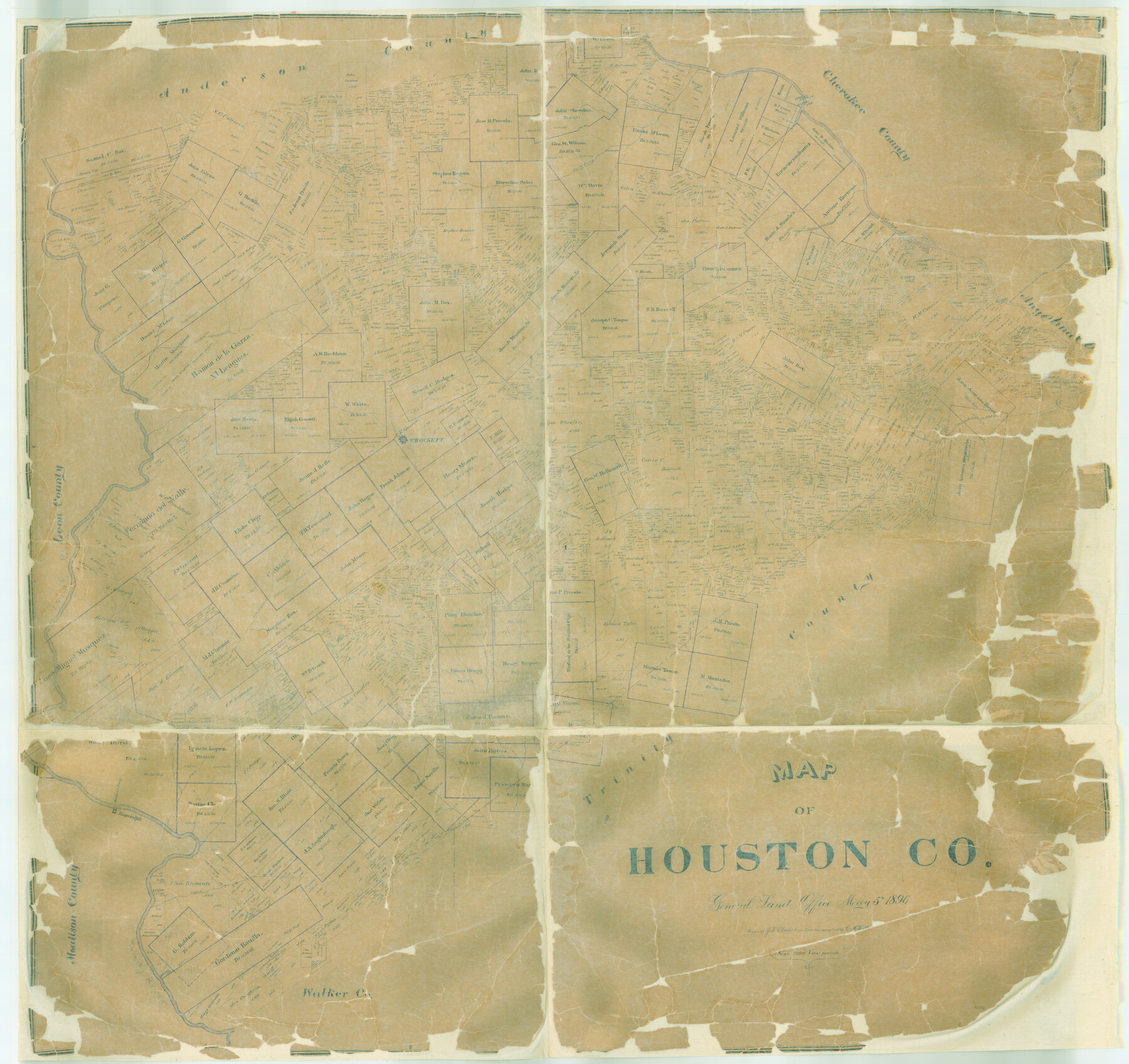
Map of Houston Co.
-
Map/Doc
4688
-
Collection
General Map Collection
-
Object Dates
1896/5/5 (Creation Date)
-
People and Organizations
Texas General Land Office (Publisher)
C.M. Hill (Compiler)
J.F. Clark (Draftsman)
-
Counties
Houston
-
Subjects
County
-
Height x Width
46.2 x 49.0 inches
117.3 x 124.5 cm
-
Features
Pine Creek
Bidais Creek
Negro Creek
Randolph
Robbins Ferry
Lost Creek
Mustang Creek
Cantabogue Creek
Caney Bayou
Gossett's Creek
Crockett
San Pedro Creek
Trinity River
Hurricane Bayou
Hog Creek
Cochino Bayou
Conners Creek
Little Elkhart Creek
Elkhart Creek
Rose Bayou
Walnut Creek
Neches River
Part of: General Map Collection
Webb County Sketch File 9-1

Print $20.00
- Digital $50.00
Webb County Sketch File 9-1
1879
Size 15.8 x 15.7 inches
Map/Doc 12622
Johnson County Sketch File 5

Print $20.00
- Digital $50.00
Johnson County Sketch File 5
1874
Size 33.3 x 14.3 inches
Map/Doc 11890
Flight Mission No. DQN-7K, Frame 3, Calhoun County

Print $20.00
- Digital $50.00
Flight Mission No. DQN-7K, Frame 3, Calhoun County
1953
Size 18.5 x 22.2 inches
Map/Doc 84454
Scurry County Rolled Sketch 6

Print $20.00
- Digital $50.00
Scurry County Rolled Sketch 6
1944
Size 29.0 x 28.8 inches
Map/Doc 7766
Pecos County Sketch File 20

Print $20.00
- Digital $50.00
Pecos County Sketch File 20
Size 25.9 x 12.0 inches
Map/Doc 12160
Lamar County Working Sketch 3

Print $20.00
- Digital $50.00
Lamar County Working Sketch 3
1919
Size 26.2 x 24.5 inches
Map/Doc 70264
Hall County Sketch File B and B1

Print $14.00
- Digital $50.00
Hall County Sketch File B and B1
Size 9.2 x 8.5 inches
Map/Doc 24780
Coast Chart No. 211 - Padre I. and Laguna Madre, Lat. 27° 12' to Lat. 26° 33', Texas

Print $20.00
- Digital $50.00
Coast Chart No. 211 - Padre I. and Laguna Madre, Lat. 27° 12' to Lat. 26° 33', Texas
1890
Size 40.1 x 33.7 inches
Map/Doc 73500
Zavala County Working Sketch 31

Print $20.00
- Digital $50.00
Zavala County Working Sketch 31
2019
Size 36.0 x 24.2 inches
Map/Doc 95407
Hamilton County Sketch File 24

Print $20.00
- Digital $50.00
Hamilton County Sketch File 24
1953
Size 23.2 x 22.8 inches
Map/Doc 11619
[Sketch for Mineral Application 33721 - 33725 Incl. - Padre and Mustang Island]
![2868, [Sketch for Mineral Application 33721 - 33725 Incl. - Padre and Mustang Island], General Map Collection](https://historictexasmaps.com/wmedia_w700/maps/2868.tif.jpg)
Print $20.00
- Digital $50.00
[Sketch for Mineral Application 33721 - 33725 Incl. - Padre and Mustang Island]
1942
Size 29.7 x 22.3 inches
Map/Doc 2868
Montgomery County Rolled Sketch 12

Print $20.00
- Digital $50.00
Montgomery County Rolled Sketch 12
Size 23.4 x 30.5 inches
Map/Doc 6801
You may also like
Jack County Sketch File 4

Print $4.00
- Digital $50.00
Jack County Sketch File 4
1857
Size 9.0 x 12.7 inches
Map/Doc 27506
Hood County Rolled Sketch 3

Print $20.00
- Digital $50.00
Hood County Rolled Sketch 3
1967
Size 33.2 x 36.2 inches
Map/Doc 9179
Dimmit County Rolled Sketch 12

Print $20.00
- Digital $50.00
Dimmit County Rolled Sketch 12
1942
Size 19.8 x 21.5 inches
Map/Doc 5721
Bosque County Working Sketch 18

Print $20.00
- Digital $50.00
Bosque County Working Sketch 18
1976
Size 18.8 x 24.4 inches
Map/Doc 67451
Flight Mission No. DAH-17M, Frame 65, Orange County

Print $20.00
- Digital $50.00
Flight Mission No. DAH-17M, Frame 65, Orange County
1953
Size 18.8 x 22.5 inches
Map/Doc 86899
Hutchinson County Rolled Sketch 37A

Print $40.00
- Digital $50.00
Hutchinson County Rolled Sketch 37A
1950
Size 26.0 x 51.1 inches
Map/Doc 9247

Umbarger in Randall County, Texas

Print $20.00
- Digital $50.00
Umbarger in Randall County, Texas
1905
Size 31.9 x 30.8 inches
Map/Doc 92158
[Area to the West and North of the Abraham Winfrey survey 11]
![90222, [Area to the West and North of the Abraham Winfrey survey 11], Twichell Survey Records](https://historictexasmaps.com/wmedia_w700/maps/90222-1.tif.jpg)
Print $20.00
- Digital $50.00
[Area to the West and North of the Abraham Winfrey survey 11]
1920
Size 25.7 x 22.5 inches
Map/Doc 90222
Fort Bend County Sketch File 12

Print $20.00
- Digital $50.00
Fort Bend County Sketch File 12
Size 24.6 x 18.2 inches
Map/Doc 11503
Williamson County Working Sketch 1

Print $20.00
- Digital $50.00
Williamson County Working Sketch 1
Size 18.2 x 23.3 inches
Map/Doc 72561
Robertson County Sketch File 12

Print $18.00
Robertson County Sketch File 12
1987
Size 11.4 x 8.8 inches
Map/Doc 35404