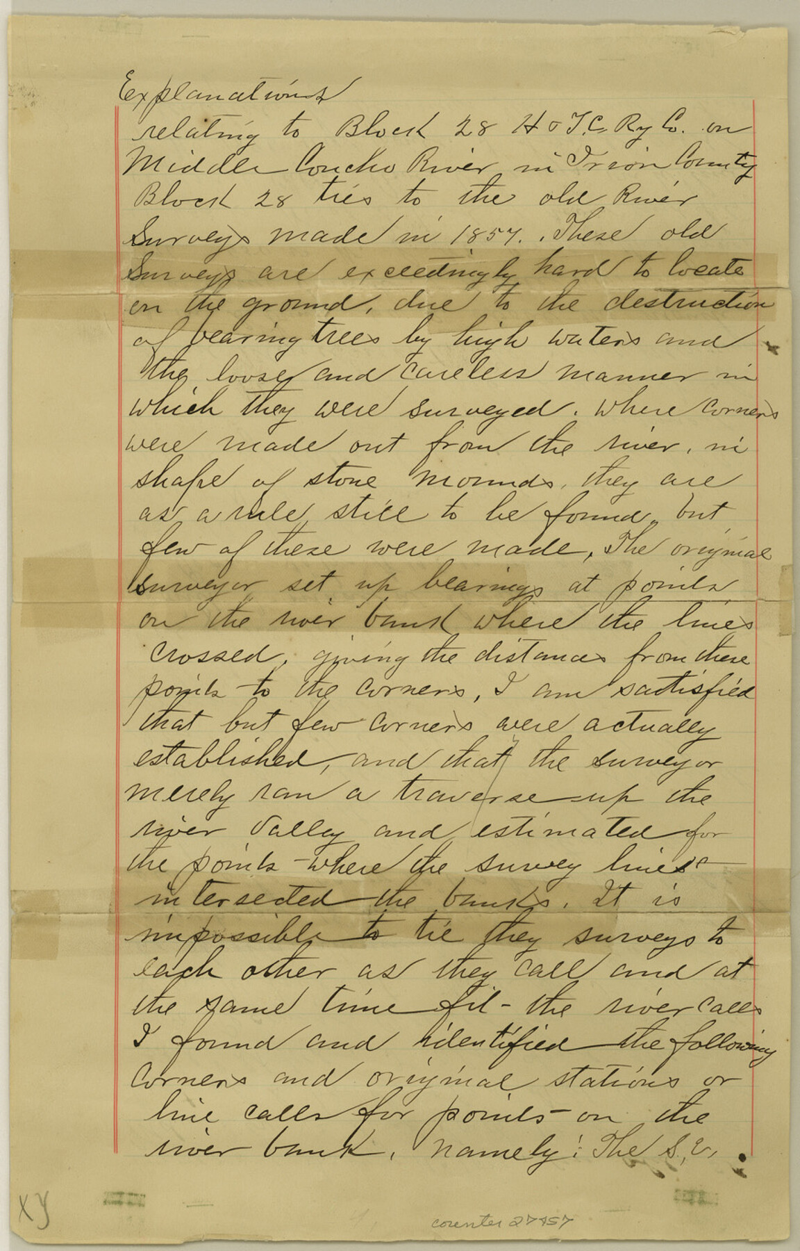
Irion County Sketch File 4
[Statement regarding H. & T. C. RR. Co. Block 28]
-
Map/Doc
27457
-
Collection
General Map Collection
-
Object Dates
1900/3/29 (Creation Date)
1901/2/4 (File Date)
1857 (Survey Date)
1900/3/29 (Survey Date)
-
People and Organizations
George M. Williams (Surveyor/Engineer)
-
Counties
Irion
-
Subjects
Surveying Sketch File
-
Height x Width
13.7 x 8.8 inches
34.8 x 22.4 cm
-
Medium
paper, manuscript
-
Features
Middle Concho River
Part of: General Map Collection
Winkler County Rolled Sketch CE-1

Print $20.00
- Digital $50.00
Winkler County Rolled Sketch CE-1
1936
Size 36.8 x 35.5 inches
Map/Doc 10149
Hardin County Sketch File 55

Print $40.00
- Digital $50.00
Hardin County Sketch File 55
1924
Size 14.2 x 13.3 inches
Map/Doc 25220
Brazoria County Rolled Sketch 23

Print $20.00
- Digital $50.00
Brazoria County Rolled Sketch 23
1931
Size 39.2 x 37.3 inches
Map/Doc 10691
Webb County Sketch File 4-2

Print $20.00
- Digital $50.00
Webb County Sketch File 4-2
1925
Size 26.3 x 18.1 inches
Map/Doc 12615
Crane County Working Sketch 14

Print $20.00
- Digital $50.00
Crane County Working Sketch 14
1946
Size 16.0 x 22.3 inches
Map/Doc 68291
Gaines County Sketch File 4

Print $4.00
- Digital $50.00
Gaines County Sketch File 4
1902
Size 14.3 x 8.5 inches
Map/Doc 23175
Crockett County Working Sketch 60

Print $20.00
- Digital $50.00
Crockett County Working Sketch 60
1955
Size 45.8 x 35.3 inches
Map/Doc 68393

[Map of Texas and Pacific Blocks from Brazos River westward through Palo Pinto, Stephens, Shackelford, Jones, Callahan, Taylor, Fisher, Nolan and Mitchell Counties]
![64510, [Map of Texas and Pacific Blocks from Brazos River westward through Palo Pinto, Stephens, Shackelford, Jones, Callahan, Taylor, Fisher, Nolan and Mitchell Counties], General Map Collection](https://historictexasmaps.com/wmedia_w700/maps/64510-1.tif.jpg)
Print $20.00
- Digital $50.00
[Map of Texas and Pacific Blocks from Brazos River westward through Palo Pinto, Stephens, Shackelford, Jones, Callahan, Taylor, Fisher, Nolan and Mitchell Counties]
Size 35.5 x 19.0 inches
Map/Doc 64510
Clay County Sketch File 3

Print $2.00
- Digital $50.00
Clay County Sketch File 3
Size 8.7 x 7.7 inches
Map/Doc 18391
Wharton County Working Sketch 20

Print $20.00
- Digital $50.00
Wharton County Working Sketch 20
1938
Size 39.1 x 42.2 inches
Map/Doc 72484
Val Verde County Rolled Sketch 83

Print $20.00
- Digital $50.00
Val Verde County Rolled Sketch 83
Size 21.1 x 40.1 inches
Map/Doc 8143
You may also like
Coast Chart No. 210 Aransas Pass and Corpus Christi Bay with the coast to latitude 27° 12' Texas

Print $20.00
- Digital $50.00
Coast Chart No. 210 Aransas Pass and Corpus Christi Bay with the coast to latitude 27° 12' Texas
1887
Size 27.6 x 18.2 inches
Map/Doc 72789
Knox County Boundary File 1

Print $24.00
- Digital $50.00
Knox County Boundary File 1
Size 14.2 x 8.6 inches
Map/Doc 64998
McMullen County Rolled Sketch 5

Print $20.00
- Digital $50.00
McMullen County Rolled Sketch 5
Size 46.4 x 26.8 inches
Map/Doc 6723
Plat Showing Block Z, W. D. and F. W. Johnson Subdivision, Bailey County, Texas

Print $20.00
- Digital $50.00
Plat Showing Block Z, W. D. and F. W. Johnson Subdivision, Bailey County, Texas
1955
Size 24.3 x 15.7 inches
Map/Doc 92538
Brewster County Working Sketch 106

Print $20.00
- Digital $50.00
Brewster County Working Sketch 106
1980
Size 43.3 x 31.8 inches
Map/Doc 67706
Montgomery County Working Sketch 22

Print $20.00
- Digital $50.00
Montgomery County Working Sketch 22
1936
Size 31.9 x 25.6 inches
Map/Doc 71129
Kimble County Working Sketch 95

Print $20.00
- Digital $50.00
Kimble County Working Sketch 95
1994
Size 36.2 x 45.9 inches
Map/Doc 70163
United States - Gulf Coast - From Latitude 26° 33' to the Rio Grande Texas

Print $20.00
- Digital $50.00
United States - Gulf Coast - From Latitude 26° 33' to the Rio Grande Texas
1919
Size 27.5 x 18.2 inches
Map/Doc 72853
Flight Mission No. BQY-4M, Frame 54, Harris County

Print $20.00
- Digital $50.00
Flight Mission No. BQY-4M, Frame 54, Harris County
1953
Size 18.6 x 22.4 inches
Map/Doc 85263
Deaf Smith County

Print $20.00
- Digital $50.00
Deaf Smith County
1926
Size 32.9 x 41.3 inches
Map/Doc 77260
Wilbarger County Sketch File 11

Print $4.00
- Digital $50.00
Wilbarger County Sketch File 11
1885
Size 14.2 x 8.6 inches
Map/Doc 40183
[Southwest 1/4 of Northwest 1/4 of County in vicinity of surveys 1281, 1282, 1297 and 1302]
![90897, [Southwest 1/4 of Northwest 1/4 of County in vicinity of surveys 1281, 1282, 1297 and 1302], Twichell Survey Records](https://historictexasmaps.com/wmedia_w700/maps/90897-1.tif.jpg)
Print $20.00
- Digital $50.00
[Southwest 1/4 of Northwest 1/4 of County in vicinity of surveys 1281, 1282, 1297 and 1302]
Size 21.5 x 14.2 inches
Map/Doc 90897