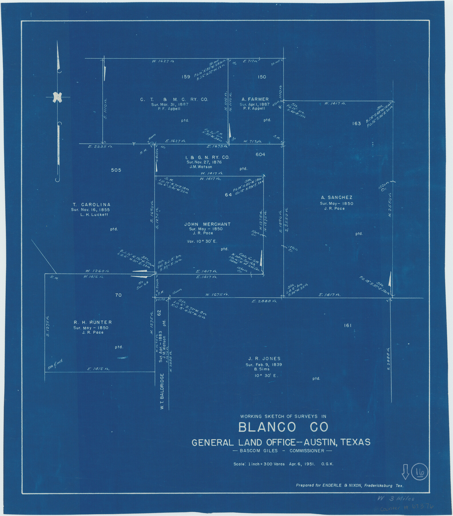
Blanco County Working Sketch 16
-
Map/Doc
67376
-
Collection
General Map Collection
-
Object Dates
4/6/1951 (Creation Date)
-
People and Organizations
Bascom Giles (GLO Commissioner)
Otto G. Kurio (Draftsman)
-
Counties
Blanco
-
Subjects
Surveying Working Sketch
-
Height x Width
22.2 x 19.5 inches
56.4 x 49.5 cm
-
Scale
1" = 300 varas
-
Comments
Surveys located about three miles West of Johnson City, Texas.
Part of: General Map Collection
Cottle County Rolled Sketch 13

Print $20.00
- Digital $50.00
Cottle County Rolled Sketch 13
1976
Size 21.6 x 35.5 inches
Map/Doc 5571
[Valdez and Martinez grants in the Goliad District]
![54, [Valdez and Martinez grants in the Goliad District], General Map Collection](https://historictexasmaps.com/wmedia_w700/maps/54.tif.jpg)
Print $3.00
- Digital $50.00
[Valdez and Martinez grants in the Goliad District]
1842
Size 10.6 x 9.5 inches
Map/Doc 54
Van Zandt County Sketch File 38

Print $4.00
- Digital $50.00
Van Zandt County Sketch File 38
1871
Size 8.2 x 10.1 inches
Map/Doc 39482
Nueces County Rolled Sketch 60

Print $40.00
- Digital $50.00
Nueces County Rolled Sketch 60
Size 95.5 x 32.3 inches
Map/Doc 9607
Travis County Sketch File 73

Print $8.00
- Digital $50.00
Travis County Sketch File 73
1848
Size 12.8 x 8.3 inches
Map/Doc 38464
Baylor County Sketch File 12E

Print $11.00
- Digital $50.00
Baylor County Sketch File 12E
1900
Size 14.3 x 8.8 inches
Map/Doc 14159
Flight Mission No. DCL-6C, Frame 180, Kenedy County

Print $20.00
- Digital $50.00
Flight Mission No. DCL-6C, Frame 180, Kenedy County
1943
Size 18.5 x 22.4 inches
Map/Doc 85992
Brewster County Working Sketch 117

Print $20.00
- Digital $50.00
Brewster County Working Sketch 117
1988
Size 33.3 x 37.0 inches
Map/Doc 67717
Kinney County Sketch File E

Print $10.00
- Digital $50.00
Kinney County Sketch File E
1885
Size 10.7 x 8.1 inches
Map/Doc 29124
Zavala County Working Sketch 12

Print $20.00
- Digital $50.00
Zavala County Working Sketch 12
1956
Size 31.5 x 30.2 inches
Map/Doc 62087
Montgomery County Texas Historical Map

Montgomery County Texas Historical Map
Size 23.2 x 35.3 inches
Map/Doc 94404
Yoakum County Sketch File 14

Print $22.00
- Digital $50.00
Yoakum County Sketch File 14
1937
Size 14.5 x 14.6 inches
Map/Doc 40791
You may also like
Hays County Rolled Sketch 25

Print $20.00
- Digital $50.00
Hays County Rolled Sketch 25
1925
Size 17.5 x 40.0 inches
Map/Doc 6181
[F. W. & D. C. Ry. Co. Alignment and Right of Way Map, Clay County]
![64732, [F. W. & D. C. Ry. Co. Alignment and Right of Way Map, Clay County], General Map Collection](https://historictexasmaps.com/wmedia_w700/maps/64732-GC.tif.jpg)
Print $20.00
- Digital $50.00
[F. W. & D. C. Ry. Co. Alignment and Right of Way Map, Clay County]
1927
Size 18.6 x 11.8 inches
Map/Doc 64732
Karnes County Sketch File 15

Print $28.00
- Digital $50.00
Karnes County Sketch File 15
1922
Size 11.4 x 8.8 inches
Map/Doc 28618
[Sketch of part of Blks. 4, 6, B5, 2Z, M6, M8, and M13]
![89643, [Sketch of part of Blks. 4, 6, B5, 2Z, M6, M8, and M13], Twichell Survey Records](https://historictexasmaps.com/wmedia_w700/maps/89643-1.tif.jpg)
Print $40.00
- Digital $50.00
[Sketch of part of Blks. 4, 6, B5, 2Z, M6, M8, and M13]
Size 55.2 x 26.8 inches
Map/Doc 89643
Borden County Sketch File 12

Print $24.00
- Digital $50.00
Borden County Sketch File 12
Size 10.8 x 9.1 inches
Map/Doc 14732
Right of Way and Track Map Houston & Texas Central R.R. operated by the T. & N.O. R.R. Co., Austin Branch

Print $40.00
- Digital $50.00
Right of Way and Track Map Houston & Texas Central R.R. operated by the T. & N.O. R.R. Co., Austin Branch
1918
Size 25.5 x 57.7 inches
Map/Doc 64553
General Highway Map, Sabine County, Texas

Print $20.00
General Highway Map, Sabine County, Texas
1940
Size 24.7 x 18.3 inches
Map/Doc 79233
Terrell County Working Sketch 57

Print $20.00
- Digital $50.00
Terrell County Working Sketch 57
1959
Size 30.0 x 25.8 inches
Map/Doc 69578
Nouvelle Carte du Mexique du Texas et d'une partie des états limitrophes

Print $20.00
- Digital $50.00
Nouvelle Carte du Mexique du Texas et d'une partie des états limitrophes
1834
Size 39.9 x 27.4 inches
Map/Doc 94098
Wood County Rolled Sketch 4

Print $20.00
- Digital $50.00
Wood County Rolled Sketch 4
1943
Size 37.0 x 29.2 inches
Map/Doc 8283
Coke County Rolled Sketch 19A

Print $20.00
- Digital $50.00
Coke County Rolled Sketch 19A
1954
Size 19.9 x 24.8 inches
Map/Doc 5520
Crane County Working Sketch 33

Print $20.00
- Digital $50.00
Crane County Working Sketch 33
1985
Size 30.3 x 27.6 inches
Map/Doc 68310