Baylor County Sketch File 12E
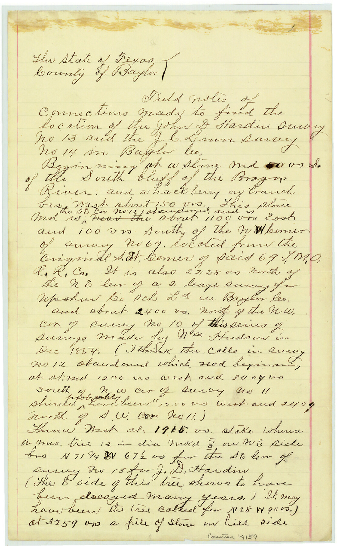
[Connecting line and sketch of surveys between Upshur County School Land and the Brazos River to the north]
-
Map/Doc
14159
-
Collection
General Map Collection
-
Object Dates
1900/11/12 (Survey Date)
1900/11/17 (Creation Date)
1900/11/22 (File Date)
-
People and Organizations
Milton Howe (Chainman/Field Personnel)
Low Howe (Chainman/Field Personnel)
A.D. Kerr (Surveyor/Engineer)
-
Counties
Baylor
-
Subjects
Surveying Sketch File
-
Height x Width
14.3 x 8.8 inches
36.3 x 22.4 cm
-
Medium
paper, manuscript
-
Features
Brazos River
Part of: General Map Collection
Victoria County Sketch File 8

Print $2.00
- Digital $50.00
Victoria County Sketch File 8
Size 5.7 x 5.6 inches
Map/Doc 39524
Matagorda Bay and Approaches

Print $20.00
- Digital $50.00
Matagorda Bay and Approaches
1957
Size 35.1 x 44.8 inches
Map/Doc 73381
Red River County Working Sketch 63

Print $20.00
- Digital $50.00
Red River County Working Sketch 63
1973
Size 43.6 x 37.0 inches
Map/Doc 72046
Pecos County Sketch File 77

Print $4.00
- Digital $50.00
Pecos County Sketch File 77
1943
Size 11.2 x 8.7 inches
Map/Doc 33909
Old Miscellaneous File 25

Print $40.00
- Digital $50.00
Old Miscellaneous File 25
Size 17.8 x 15.2 inches
Map/Doc 75632
Houston County Rolled Sketch 11

Print $20.00
- Digital $50.00
Houston County Rolled Sketch 11
1988
Size 29.9 x 22.9 inches
Map/Doc 6231
Travis County

Print $40.00
- Digital $50.00
Travis County
1963
Size 37.7 x 50.7 inches
Map/Doc 73597
Victoria County Sketch File A

Print $20.00
- Digital $50.00
Victoria County Sketch File A
1902
Size 23.7 x 22.4 inches
Map/Doc 12597
Flight Mission No. BRA-16M, Frame 168, Jefferson County

Print $20.00
- Digital $50.00
Flight Mission No. BRA-16M, Frame 168, Jefferson County
1953
Size 18.7 x 22.5 inches
Map/Doc 85766
Armstrong County Working Sketch 2

Print $20.00
- Digital $50.00
Armstrong County Working Sketch 2
1904
Size 29.0 x 23.4 inches
Map/Doc 67233
Blanco County Working Sketch 11

Print $3.00
- Digital $50.00
Blanco County Working Sketch 11
1941
Size 10.8 x 10.4 inches
Map/Doc 67371
Presidio County Sketch File 72

Print $6.00
- Digital $50.00
Presidio County Sketch File 72
1943
Size 13.3 x 8.8 inches
Map/Doc 34679
You may also like
Brazoria County Sketch File 17

Print $24.00
- Digital $50.00
Brazoria County Sketch File 17
1914
Size 11.1 x 8.8 inches
Map/Doc 14988
Atascosa County Sketch File 10

Print $4.00
- Digital $50.00
Atascosa County Sketch File 10
Size 12.1 x 7.7 inches
Map/Doc 13765
Clay County Sketch File 14

Print $40.00
- Digital $50.00
Clay County Sketch File 14
1873
Size 16.5 x 13.8 inches
Map/Doc 18417
Map of Eastland Co.

Print $20.00
- Digital $50.00
Map of Eastland Co.
1896
Size 43.2 x 43.1 inches
Map/Doc 78410
Gaines County Working Sketch 30

Print $20.00
- Digital $50.00
Gaines County Working Sketch 30
1990
Size 18.3 x 26.4 inches
Map/Doc 69330
Atascosa County Sketch File 15

Print $6.00
- Digital $50.00
Atascosa County Sketch File 15
1879
Size 7.1 x 13.5 inches
Map/Doc 13775
Harbor of Brazos Santiago, Texas

Print $20.00
- Digital $50.00
Harbor of Brazos Santiago, Texas
1887
Size 27.3 x 18.3 inches
Map/Doc 72992
San Jacinto County Boundary File 1

Print $6.00
- Digital $50.00
San Jacinto County Boundary File 1
Size 9.6 x 8.4 inches
Map/Doc 58548
Hopkins County Sketch File 16b

Print $7.00
- Digital $50.00
Hopkins County Sketch File 16b
1870
Size 8.1 x 12.8 inches
Map/Doc 26717
Blanco County Sketch File 21a

Print $4.00
- Digital $50.00
Blanco County Sketch File 21a
Size 8.3 x 12.0 inches
Map/Doc 14602
Val Verde County Sketch File 41

Print $20.00
- Digital $50.00
Val Verde County Sketch File 41
1938
Size 17.8 x 22.7 inches
Map/Doc 12583
Johnson County Working Sketch 23

Print $20.00
- Digital $50.00
Johnson County Working Sketch 23
1997
Size 25.3 x 22.8 inches
Map/Doc 66636