McCulloch County Rolled Sketch 9
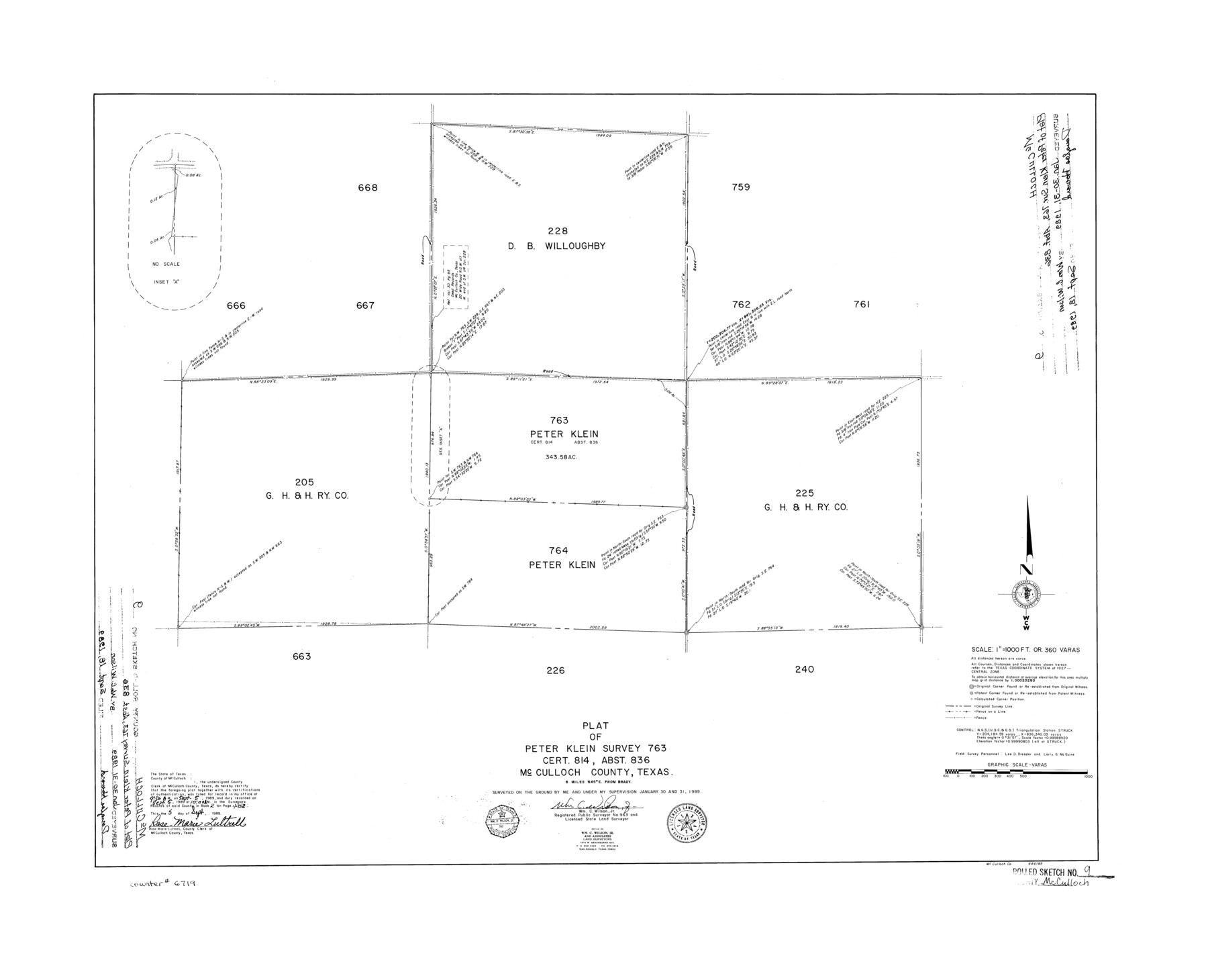
Plat of Peter Klein survey 763, cert. 814, abst. 836, McCulloch County, Texas
-
Map/Doc
6719
-
Collection
General Map Collection
-
Object Dates
1989/9/18 (File Date)
1989/1/31 (Survey Date)
-
People and Organizations
Wm. C. Wilson, Jr. (Surveyor/Engineer)
Lee D. Dressler (Chainman/Field Personnel)
Larry G. McGuire (Chainman/Field Personnel)
-
Counties
McCulloch
-
Subjects
Surveying Rolled Sketch
-
Height x Width
21.0 x 25.9 inches
53.3 x 65.8 cm
-
Medium
mylar, print
-
Scale
1" = 360 varas
Part of: General Map Collection
Brewster County Rolled Sketch 49B

Print $20.00
- Digital $50.00
Brewster County Rolled Sketch 49B
Size 14.2 x 24.2 inches
Map/Doc 5225
Duval County Sketch File 42

Print $4.00
- Digital $50.00
Duval County Sketch File 42
1936
Size 14.4 x 8.8 inches
Map/Doc 21394
Smith County Sketch File 2

Print $4.00
- Digital $50.00
Smith County Sketch File 2
1853
Size 12.7 x 8.5 inches
Map/Doc 36748
South Part Pecos County

Print $20.00
- Digital $50.00
South Part Pecos County
1976
Size 36.8 x 44.2 inches
Map/Doc 73262
Tarrant County

Print $20.00
- Digital $50.00
Tarrant County
1856
Size 22.1 x 19.3 inches
Map/Doc 4068
Jasper County Sketch File 33

Print $20.00
- Digital $50.00
Jasper County Sketch File 33
1938
Size 23.0 x 17.6 inches
Map/Doc 11854
Grayson County Working Sketch 23

Print $20.00
- Digital $50.00
Grayson County Working Sketch 23
1976
Size 18.6 x 24.3 inches
Map/Doc 63262

Tom Green County Rolled Sketch 22

Print $20.00
- Digital $50.00
Tom Green County Rolled Sketch 22
1966
Size 38.0 x 43.6 inches
Map/Doc 10006
Potter County Sketch File 1

Print $28.00
- Digital $50.00
Potter County Sketch File 1
1882
Size 7.4 x 8.8 inches
Map/Doc 34378
Taylor County Sketch File 12

Print $4.00
- Digital $50.00
Taylor County Sketch File 12
Size 8.6 x 12.8 inches
Map/Doc 37796
Dimmit County Sketch File 9

Print $6.00
- Digital $50.00
Dimmit County Sketch File 9
Size 8.9 x 11.2 inches
Map/Doc 21070
You may also like
[North line of T. & P. Block 31, Township 6N]
![90554, [North line of T. & P. Block 31, Township 6N], Twichell Survey Records](https://historictexasmaps.com/wmedia_w700/maps/90554-1.tif.jpg)
Print $2.00
- Digital $50.00
[North line of T. & P. Block 31, Township 6N]
Size 7.5 x 4.7 inches
Map/Doc 90554
Parmer County Working Sketch Graphic Index

Print $20.00
- Digital $50.00
Parmer County Working Sketch Graphic Index
1926
Map/Doc 76662
Flight Mission No. DAG-21K, Frame 107, Matagorda County

Print $20.00
- Digital $50.00
Flight Mission No. DAG-21K, Frame 107, Matagorda County
1952
Size 18.6 x 22.4 inches
Map/Doc 86435
Lee County Working Sketch 12

Print $20.00
- Digital $50.00
Lee County Working Sketch 12
1980
Size 12.3 x 16.3 inches
Map/Doc 70391
Wise County Sketch File 14

Print $24.00
- Digital $50.00
Wise County Sketch File 14
1855
Size 12.8 x 8.2 inches
Map/Doc 40548
Aransas County Sketch File 9

Print $40.00
- Digital $50.00
Aransas County Sketch File 9
Size 17.5 x 19.8 inches
Map/Doc 10819
DeWitt County Rolled Sketch 2

Print $20.00
- Digital $50.00
DeWitt County Rolled Sketch 2
1943
Size 32.0 x 42.7 inches
Map/Doc 8778
Coast Chart No. 212 - From Latitude 26° 33' to the Rio Grande Texas

Print $20.00
- Digital $50.00
Coast Chart No. 212 - From Latitude 26° 33' to the Rio Grande Texas
1886
Size 27.7 x 18.2 inches
Map/Doc 72827
Flight Mission No. DQN-2K, Frame 188, Calhoun County

Print $20.00
- Digital $50.00
Flight Mission No. DQN-2K, Frame 188, Calhoun County
1953
Size 18.6 x 22.3 inches
Map/Doc 84329
"Old Three Hundred" Land Grants under Austin's First Contract

"Old Three Hundred" Land Grants under Austin's First Contract
2023
Size 8.5 x 11.0 inches
Map/Doc 97185

Americae Nova Descriptio

Print $20.00
- Digital $50.00
Americae Nova Descriptio
1663
Size 14.5 x 18.0 inches
Map/Doc 95708