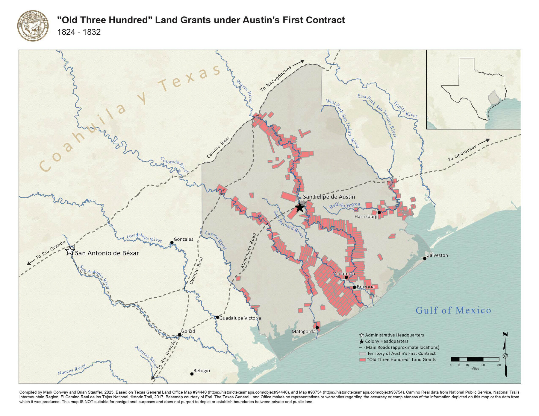
"Old Three Hundred" Land Grants under Austin's First Contract
1824-1832
-
Map/Doc
97185
-
Collection
GIS Educational Maps
-
Object Dates
2023 (Creation Date)
-
People and Organizations
Mark Conway (Compiler)
Brian A. Stauffer (Compiler)
-
Subjects
Colony Mexican Texas Geographic Information System
-
Height x Width
8.5 x 11.0 inches
21.6 x 27.9 cm
-
Medium
pdf
-
Comments
See Best Laid Plat: San Felipe de Austin in Vision and Reality, 1823-1836 for a StoryMap exploring the history of Stephen F. Austin’s colony.
Part of: GIS Educational Maps
Events of the Texas Revolution

Events of the Texas Revolution
2023
Size 11.0 x 17.0 inches
Map/Doc 97194


Big Inch and Little Big Inch Pipelines

Big Inch and Little Big Inch Pipelines
2022
Size 8.5 x 11.0 inches
Map/Doc 97089
Disputed Territory Between Mexico and the United States

Disputed Territory Between Mexico and the United States
2024
Size 10.7 x 7.9 inches
Map/Doc 97251
Texas Population Distribution in Cities, per the U.S. Census of 1910

Texas Population Distribution in Cities, per the U.S. Census of 1910
2022
Size 11.0 x 8.5 inches
Map/Doc 97092
United States Population Distribution by County and Territory, per the U.S. Census of 1900

United States Population Distribution by County and Territory, per the U.S. Census of 1900
2025
Size 8.5 x 11.0 inches
Map/Doc 97481
Northern Mexico Campaign of the U.S. - Mexico War

Northern Mexico Campaign of the U.S. - Mexico War
2023
Size 8.5 x 11.0 inches
Map/Doc 97152
Events of the Texas Revolution

Events of the Texas Revolution
2025
Size 8.5 x 11.0 inches
Map/Doc 97489
American Civil War Political Loyalties

American Civil War Political Loyalties
2022
Size 8.5 x 11.0 inches
Map/Doc 97091
United States Population Distribution by County and Territory, per the U.S. Census of 1870

United States Population Distribution by County and Territory, per the U.S. Census of 1870
2025
Size 8.5 x 11.0 inches
Map/Doc 97479
You may also like
Leon County Rolled Sketch 23

Print $20.00
- Digital $50.00
Leon County Rolled Sketch 23
1981
Size 33.6 x 40.7 inches
Map/Doc 6609
Right-of-Way & Track Map, Houston and Brazos Valley Ry. Co. operated by the Houston and Brazos Valley Ry. Co.

Print $40.00
- Digital $50.00
Right-of-Way & Track Map, Houston and Brazos Valley Ry. Co. operated by the Houston and Brazos Valley Ry. Co.
1918
Size 25.0 x 55.7 inches
Map/Doc 64605
[H. & G. N. RR. Co. Block 1]
![90892, [H. & G. N. RR. Co. Block 1], Twichell Survey Records](https://historictexasmaps.com/wmedia_w700/maps/90892-1.tif.jpg)
Print $20.00
- Digital $50.00
[H. & G. N. RR. Co. Block 1]
1902
Size 14.9 x 15.8 inches
Map/Doc 90892
Culberson County Working Sketch 3

Print $40.00
- Digital $50.00
Culberson County Working Sketch 3
Size 50.6 x 21.1 inches
Map/Doc 68455
Padre Island National Seashore, Texas - Dependent Resurvey

Print $4.00
- Digital $50.00
Padre Island National Seashore, Texas - Dependent Resurvey
2001
Size 18.4 x 24.1 inches
Map/Doc 60553
Flight Mission No. DCL-6C, Frame 7, Kenedy County

Print $20.00
- Digital $50.00
Flight Mission No. DCL-6C, Frame 7, Kenedy County
1943
Size 18.6 x 22.4 inches
Map/Doc 85867
Henderson County Rolled Sketch 7

Print $20.00
- Digital $50.00
Henderson County Rolled Sketch 7
1963
Size 22.9 x 41.9 inches
Map/Doc 6203
Coke County Working Sketch 19

Print $20.00
- Digital $50.00
Coke County Working Sketch 19
1948
Size 22.2 x 29.0 inches
Map/Doc 68056
Bell County Working Sketch 19

Print $40.00
- Digital $50.00
Bell County Working Sketch 19
1994
Size 48.3 x 38.4 inches
Map/Doc 67359
Real County Working Sketch 79

Print $20.00
- Digital $50.00
Real County Working Sketch 79
1981
Size 19.8 x 22.2 inches
Map/Doc 71971
Amistad International Reservoir on Rio Grande 80

Print $20.00
- Digital $50.00
Amistad International Reservoir on Rio Grande 80
1949
Size 28.4 x 40.2 inches
Map/Doc 75509
Frio County Working Sketch 25

Print $40.00
- Digital $50.00
Frio County Working Sketch 25
1989
Size 35.4 x 50.0 inches
Map/Doc 69299