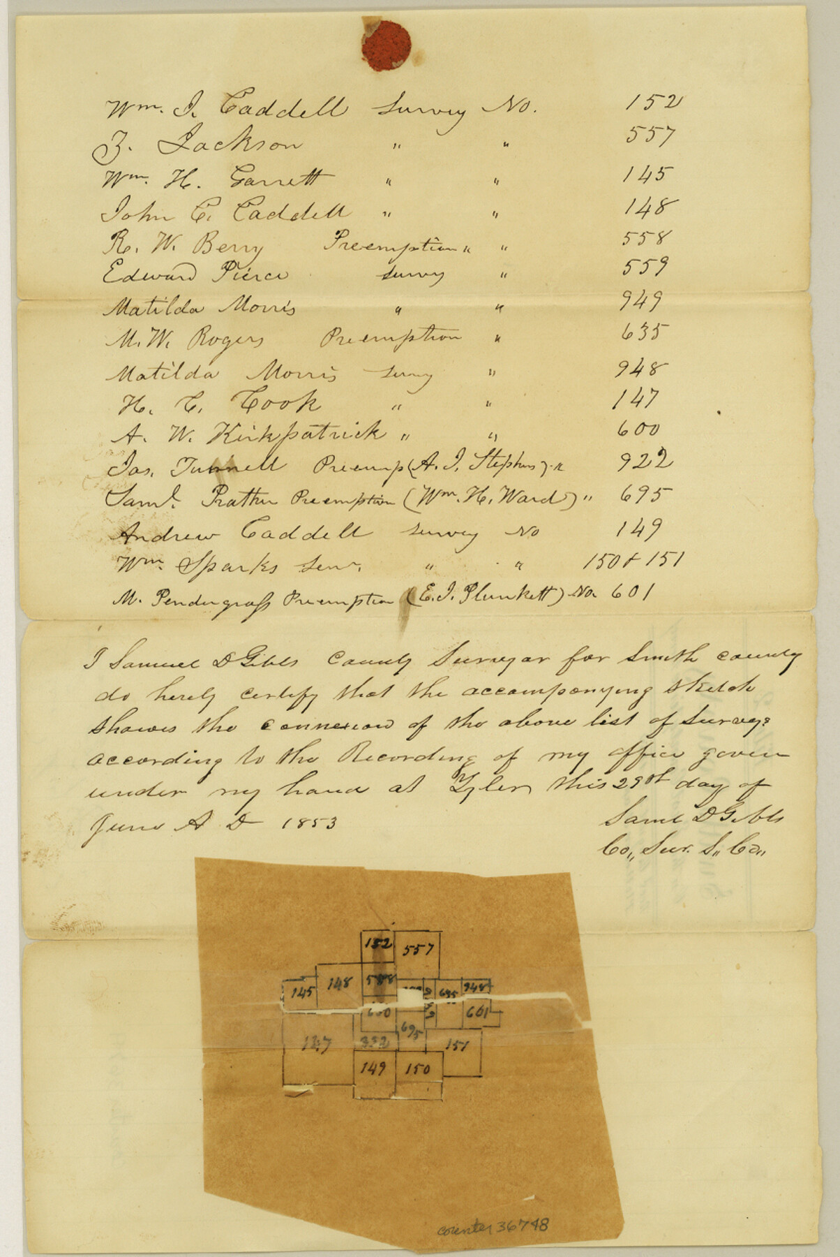
Smith County Sketch File 2
[Sketch of surveys near the east line of Smith County]
-
Map/Doc
36748
-
Collection
General Map Collection
-
Object Dates
6/29/1853 (Creation Date)
8/2/1853 (File Date)
-
People and Organizations
Samuel D. Gibbs (Surveyor/Engineer)
-
Counties
Smith
-
Subjects
Surveying Sketch File
-
Height x Width
12.7 x 8.5 inches
32.3 x 21.6 cm
-
Medium
paper, manuscript
Part of: General Map Collection
Trace of a copy of the map captured at the battle of Resaca de la Palma

Print $20.00
- Digital $50.00
Trace of a copy of the map captured at the battle of Resaca de la Palma
Size 18.3 x 27.3 inches
Map/Doc 73054
Tyler County Sketch File 19

Print $4.00
- Digital $50.00
Tyler County Sketch File 19
Size 3.5 x 6.1 inches
Map/Doc 38670
Jasper County Rolled Sketch 2

Print $20.00
- Digital $50.00
Jasper County Rolled Sketch 2
1941
Size 22.5 x 16.6 inches
Map/Doc 6348
Gillespie County Sketch File 3b

Print $4.00
- Digital $50.00
Gillespie County Sketch File 3b
1860
Size 8.2 x 12.6 inches
Map/Doc 24133
Chambers County Sketch File 22

Print $8.00
- Digital $50.00
Chambers County Sketch File 22
Size 12.2 x 7.6 inches
Map/Doc 17594
Reeves County Sketch File 28

Print $12.00
- Digital $50.00
Reeves County Sketch File 28
2003
Size 14.3 x 8.8 inches
Map/Doc 78496
Wichita County Boundary File 4

Print $20.00
- Digital $50.00
Wichita County Boundary File 4
Size 12.4 x 38.3 inches
Map/Doc 59914
Map of Lands surveyed for the Deaf & Dumb Asylum on the head waters of the Leon River

Print $20.00
- Digital $50.00
Map of Lands surveyed for the Deaf & Dumb Asylum on the head waters of the Leon River
1857
Size 13.3 x 17.1 inches
Map/Doc 2209
Bexar County Working Sketch 22

Print $20.00
- Digital $50.00
Bexar County Working Sketch 22
1986
Size 16.3 x 16.1 inches
Map/Doc 67338
San Augustine County Working Sketch 11b

Print $20.00
- Digital $50.00
San Augustine County Working Sketch 11b
Size 18.9 x 26.3 inches
Map/Doc 63699
Flight Mission No. DIX-10P, Frame 77, Aransas County

Print $20.00
- Digital $50.00
Flight Mission No. DIX-10P, Frame 77, Aransas County
1956
Size 18.6 x 22.3 inches
Map/Doc 83938
[Surveys along the Nueces River, San Patricio District]
![69739, [Surveys along the Nueces River, San Patricio District], General Map Collection](https://historictexasmaps.com/wmedia_w700/maps/69739.tif.jpg)
Print $2.00
- Digital $50.00
[Surveys along the Nueces River, San Patricio District]
1842
Size 11.3 x 7.7 inches
Map/Doc 69739
You may also like

Town of Lubbock, Texas and Additions

Print $20.00
Town of Lubbock, Texas and Additions
1935
Size 43.8 x 43.5 inches
Map/Doc 76271
Terrell County Working Sketch 30

Print $20.00
- Digital $50.00
Terrell County Working Sketch 30
1944
Size 31.4 x 25.2 inches
Map/Doc 62122
Harris County Rolled Sketch GC

Print $40.00
- Digital $50.00
Harris County Rolled Sketch GC
1917
Size 42.1 x 52.4 inches
Map/Doc 9115
Harris County Sketch File 26

Print $8.00
- Digital $50.00
Harris County Sketch File 26
Size 9.2 x 8.5 inches
Map/Doc 25393
Comanche County Working Sketch 9

Print $20.00
- Digital $50.00
Comanche County Working Sketch 9
1954
Size 18.6 x 21.5 inches
Map/Doc 68143
Robertson County Sketch File 12

Print $18.00
Robertson County Sketch File 12
1987
Size 11.4 x 8.8 inches
Map/Doc 35404
Nueces County Rolled Sketch 110A

Print $20.00
- Digital $50.00
Nueces County Rolled Sketch 110A
1990
Size 24.3 x 37.5 inches
Map/Doc 7118
Flight Mission No. CRK-3P, Frame 176, Refugio County

Print $20.00
- Digital $50.00
Flight Mission No. CRK-3P, Frame 176, Refugio County
1956
Size 18.3 x 22.2 inches
Map/Doc 86923
Map showing connections and corners made on ground in south part of Yoakum County and north part of Gaines County, Texas

Print $20.00
- Digital $50.00
Map showing connections and corners made on ground in south part of Yoakum County and north part of Gaines County, Texas
1938
Size 43.7 x 36.5 inches
Map/Doc 93255
Val Verde County Sketch File 35A

Print $18.00
- Digital $50.00
Val Verde County Sketch File 35A
1936
Size 4.4 x 7.4 inches
Map/Doc 39253
Jack County Sketch File 1

Print $4.00
- Digital $50.00
Jack County Sketch File 1
Size 8.4 x 6.4 inches
Map/Doc 27499