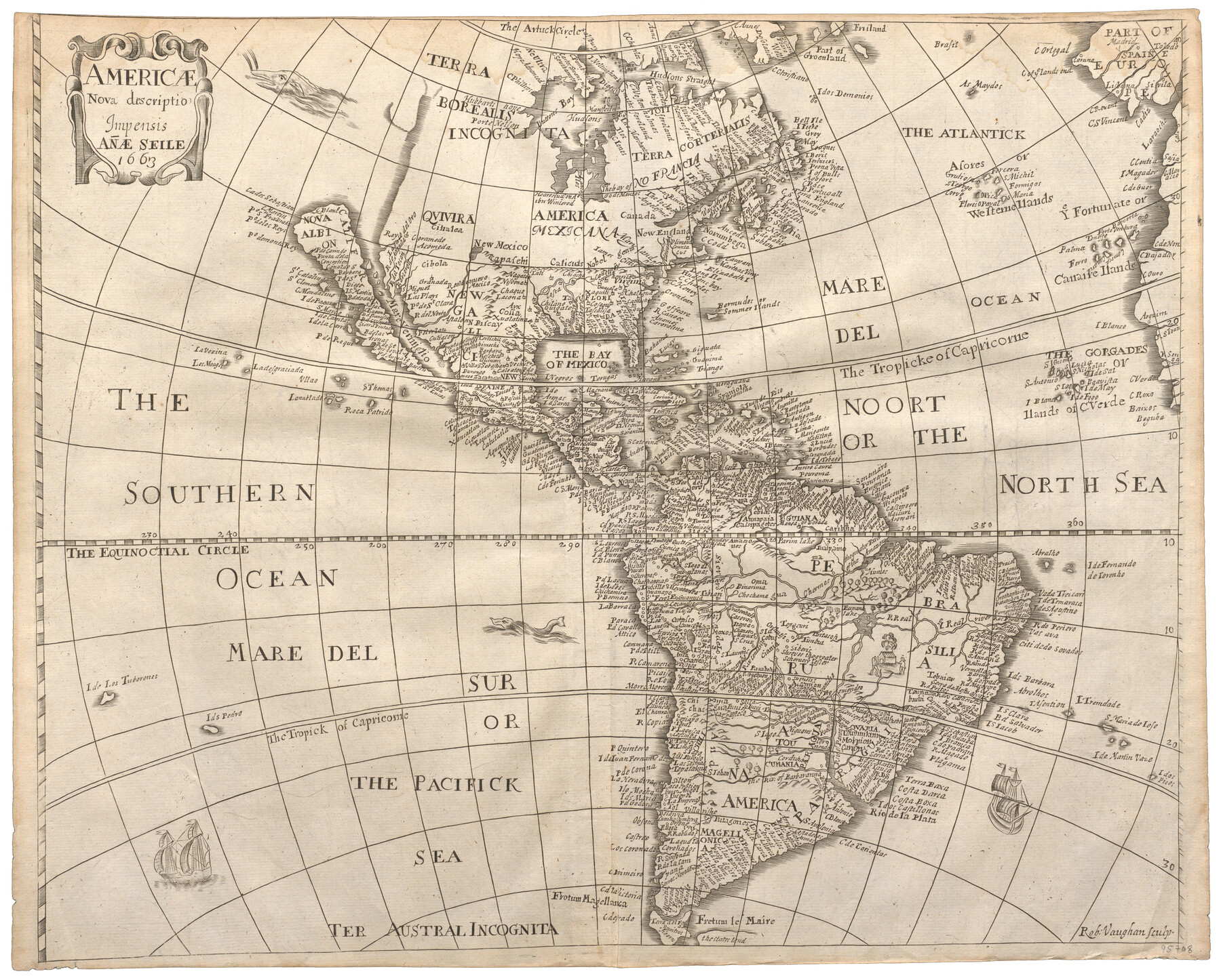
Americae Nova Descriptio
-
Map/Doc
95708
-
Collection
General Map Collection
-
Object Dates
1663 (Creation Date)
-
People and Organizations
Robert Vaughan (Printer)
Anae Seile (Cartographer)
-
Subjects
North America South America
-
Height x Width
14.5 x 18.0 inches
36.8 x 45.7 cm
-
Medium
paper, etching/engraving/lithograph
-
Comments
From the publication "Cosmography in Four Books Containing the Chorography and History of the Whole World"
Part of: General Map Collection
Stephens County Sketch File 13

Print $4.00
- Digital $50.00
Stephens County Sketch File 13
Size 11.2 x 8.8 inches
Map/Doc 37063
Menard County Working Sketch 22

Print $20.00
- Digital $50.00
Menard County Working Sketch 22
1950
Size 31.7 x 38.7 inches
Map/Doc 70969
Jefferson County

Print $20.00
- Digital $50.00
Jefferson County
1882
Size 22.8 x 20.0 inches
Map/Doc 3730
Hansford County Sketch File 9

Print $33.00
- Digital $50.00
Hansford County Sketch File 9
1928
Size 11.1 x 8.8 inches
Map/Doc 24963
C No. 2 - Preliminary Sketch of Chincoteague Inlet and Shoals in the Vicinity - Sea Coast of Virginia

Print $20.00
- Digital $50.00
C No. 2 - Preliminary Sketch of Chincoteague Inlet and Shoals in the Vicinity - Sea Coast of Virginia
1852
Size 16.5 x 19.4 inches
Map/Doc 97206
Mason County Working Sketch 4

Print $20.00
- Digital $50.00
Mason County Working Sketch 4
1932
Size 16.6 x 22.2 inches
Map/Doc 70840
Lavaca County Sketch File 6

Print $2.00
- Digital $50.00
Lavaca County Sketch File 6
Size 7.3 x 3.2 inches
Map/Doc 29641
Calhoun County NRC Article 33.136 Sketch 6

Print $24.00
- Digital $50.00
Calhoun County NRC Article 33.136 Sketch 6
2014
Size 18.0 x 24.0 inches
Map/Doc 94462
Oldham County Working Sketch 6

Print $40.00
- Digital $50.00
Oldham County Working Sketch 6
1981
Size 32.4 x 50.4 inches
Map/Doc 71328
Cherokee County Sketch File 21

Print $4.00
- Digital $50.00
Cherokee County Sketch File 21
1876
Size 8.0 x 7.4 inches
Map/Doc 18165
Map of Zapata County

Print $40.00
- Digital $50.00
Map of Zapata County
1901
Size 49.1 x 42.4 inches
Map/Doc 63144
Bexar County Working Sketch 6

Print $40.00
- Digital $50.00
Bexar County Working Sketch 6
1945
Size 56.4 x 41.2 inches
Map/Doc 67322
You may also like
Crockett County Rolled Sketch 29

Print $20.00
- Digital $50.00
Crockett County Rolled Sketch 29
1927
Size 22.0 x 36.9 inches
Map/Doc 5781
Runnels County Sketch File 37

Print $20.00
Runnels County Sketch File 37
1889
Size 24.9 x 21.3 inches
Map/Doc 12268
Red River County Sketch File 9

Print $10.00
- Digital $50.00
Red River County Sketch File 9
1862
Size 12.6 x 8.2 inches
Map/Doc 35117
Frio County Sketch File 1

Print $8.00
- Digital $50.00
Frio County Sketch File 1
1848
Size 8.6 x 7.7 inches
Map/Doc 23101
Kimble County Rolled Sketch 27

Print $20.00
- Digital $50.00
Kimble County Rolled Sketch 27
1963
Size 23.9 x 39.4 inches
Map/Doc 6517
El Paso County Sketch File 12

Print $22.00
- Digital $50.00
El Paso County Sketch File 12
1887
Size 8.1 x 5.9 inches
Map/Doc 22004
San Saba County Working Sketch 13

Print $20.00
- Digital $50.00
San Saba County Working Sketch 13
1995
Size 42.8 x 32.8 inches
Map/Doc 63801
Refugio County Boundary File 5

Print $4.00
- Digital $50.00
Refugio County Boundary File 5
Size 11.2 x 8.6 inches
Map/Doc 58256
Jefferson County Sketch File 4

Print $4.00
- Digital $50.00
Jefferson County Sketch File 4
Size 13.0 x 8.3 inches
Map/Doc 28101
Delta County, Texas

Print $20.00
- Digital $50.00
Delta County, Texas
1884
Size 14.1 x 20.0 inches
Map/Doc 416
Wilbarger County Aerial Photograph Index Sheet 1

Print $20.00
- Digital $50.00
Wilbarger County Aerial Photograph Index Sheet 1
1950
Size 22.4 x 18.9 inches
Map/Doc 83750
Culberson County Sketch File 1c

Print $4.00
- Digital $50.00
Culberson County Sketch File 1c
1859
Size 7.4 x 8.0 inches
Map/Doc 20111