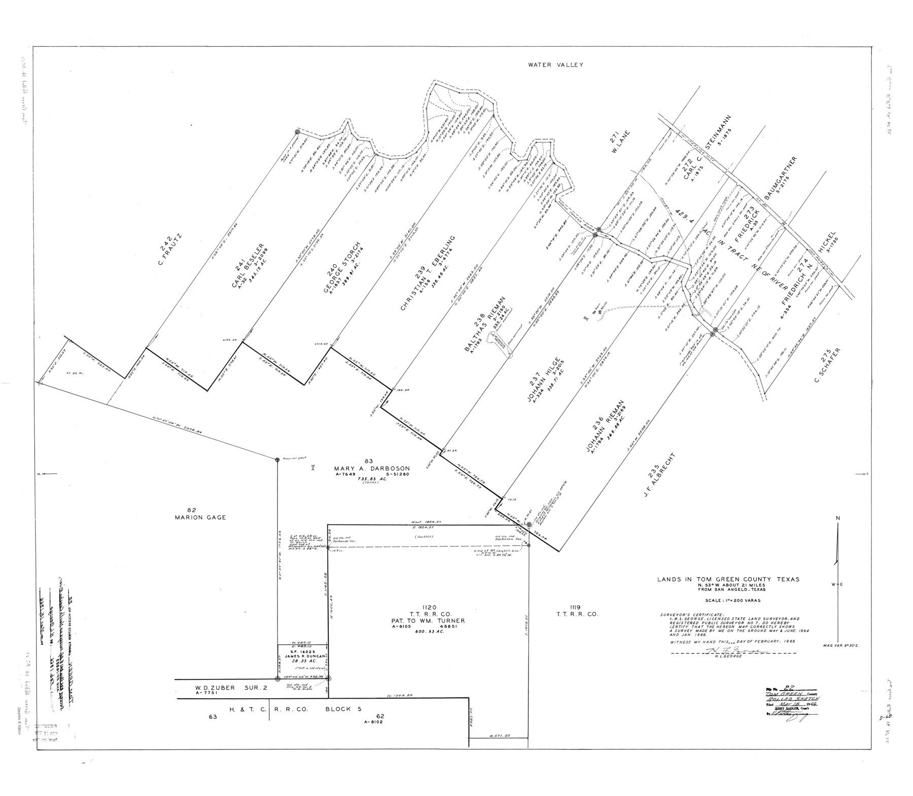
Tom Green County Rolled Sketch 22
Lands in Tom Green County, Texas [showing surveys along Concho River]
-
Map/Doc
10006
-
Collection
General Map Collection
-
Object Dates
1966 (Creation Date)
1966/3/15 (File Date)
1966 (Survey Date)
-
People and Organizations
H.L. George (Surveyor/Engineer)
-
Counties
Tom Green
-
Subjects
Surveying Rolled Sketch
-
Height x Width
38.0 x 43.6 inches
96.5 x 110.7 cm
-
Medium
mylar, print
-
Scale
1" = 200 varas
Part of: General Map Collection
Eastland County Sketch File 13

Print $4.00
- Digital $50.00
Eastland County Sketch File 13
1887
Size 8.3 x 13.0 inches
Map/Doc 21593

Kleberg County Rolled Sketch 8

Print $20.00
- Digital $50.00
Kleberg County Rolled Sketch 8
1947
Size 33.0 x 42.0 inches
Map/Doc 9360
Hood County Working Sketch 4

Print $20.00
- Digital $50.00
Hood County Working Sketch 4
1967
Size 31.6 x 36.6 inches
Map/Doc 66198
Township and Railroad Map of New Hampshire compiled from the best authorities with corrections and alteration of town lines from actual surveys

Print $20.00
- Digital $50.00
Township and Railroad Map of New Hampshire compiled from the best authorities with corrections and alteration of town lines from actual surveys
1854
Size 34.8 x 24.4 inches
Map/Doc 97105
United States - Gulf Coast - Padre I. and Laguna Madre Lat. 27° 12' to Lat. 26° 33' Texas

Print $20.00
- Digital $50.00
United States - Gulf Coast - Padre I. and Laguna Madre Lat. 27° 12' to Lat. 26° 33' Texas
1913
Size 26.8 x 18.4 inches
Map/Doc 72817
Flight Mission No. DQN-3K, Frame 51, Calhoun County

Print $20.00
- Digital $50.00
Flight Mission No. DQN-3K, Frame 51, Calhoun County
1953
Size 18.5 x 22.2 inches
Map/Doc 84352
Upton County Sketch File 40

Print $6.00
- Digital $50.00
Upton County Sketch File 40
1961
Size 11.5 x 8.7 inches
Map/Doc 38914
Brazoria County Rolled Sketch 23

Print $20.00
- Digital $50.00
Brazoria County Rolled Sketch 23
1931
Size 39.2 x 37.3 inches
Map/Doc 10691
Harris County Sketch File 67

Print $14.00
- Digital $50.00
Harris County Sketch File 67
1936
Size 11.4 x 8.9 inches
Map/Doc 25505
Pecos County Working Sketch 121

Print $20.00
- Digital $50.00
Pecos County Working Sketch 121
1973
Size 44.3 x 37.7 inches
Map/Doc 71594
Colorado County Sketch File 27

Print $20.00
- Digital $50.00
Colorado County Sketch File 27
1911
Size 25.3 x 19.4 inches
Map/Doc 11138
You may also like
Lamb County, Texas Compiled by Sylvan Sanders Lubbock, Texas

Print $20.00
- Digital $50.00
Lamb County, Texas Compiled by Sylvan Sanders Lubbock, Texas
Size 24.0 x 27.2 inches
Map/Doc 92200
Crane County Sketch File 13b

Print $40.00
- Digital $50.00
Crane County Sketch File 13b
1901
Size 11.4 x 13.8 inches
Map/Doc 19573
Map of Leagues 245, 246, 247, 250, 251, 252, 253, 254, and 321, Surveys 128, 130, 131, 132, R. E. Montgomery, and Surveys 133 and 134, Block A, Public Free School Land

Print $20.00
- Digital $50.00
Map of Leagues 245, 246, 247, 250, 251, 252, 253, 254, and 321, Surveys 128, 130, 131, 132, R. E. Montgomery, and Surveys 133 and 134, Block A, Public Free School Land
1930
Size 21.8 x 29.4 inches
Map/Doc 91270
Chart of the Rio Bravo del Norte traced from a survey made by Henry Austin by Lieut. Bowman, 3d. Infy.

Print $20.00
- Digital $50.00
Chart of the Rio Bravo del Norte traced from a survey made by Henry Austin by Lieut. Bowman, 3d. Infy.
1866
Size 18.3 x 27.8 inches
Map/Doc 72889
Cooke County Sketch File 31

Print $22.00
- Digital $50.00
Cooke County Sketch File 31
1873
Size 8.0 x 12.9 inches
Map/Doc 19293
La Salle County Sketch File 47

Print $8.00
- Digital $50.00
La Salle County Sketch File 47
1941
Size 14.2 x 8.9 inches
Map/Doc 29613
Bell County Working Sketch 9

Print $20.00
- Digital $50.00
Bell County Working Sketch 9
1954
Size 32.3 x 27.9 inches
Map/Doc 67349
Trinity River, Levee Improvement Districts, Widths of Floodways/Chambers Creek

Print $6.00
- Digital $50.00
Trinity River, Levee Improvement Districts, Widths of Floodways/Chambers Creek
1921
Size 24.9 x 31.3 inches
Map/Doc 65256
Americae nova Tabula

Print $20.00
- Digital $50.00
Americae nova Tabula
1617
Size 16.0 x 21.5 inches
Map/Doc 93813
Hardin County Rolled Sketch 15

Print $20.00
- Digital $50.00
Hardin County Rolled Sketch 15
Size 25.5 x 26.6 inches
Map/Doc 6085
Reagan County Rolled Sketch 36

Print $20.00
- Digital $50.00
Reagan County Rolled Sketch 36
1960
Size 31.0 x 13.4 inches
Map/Doc 7449
Agua Fria Quadrangle

Print $20.00
- Digital $50.00
Agua Fria Quadrangle
1917
Size 17.2 x 21.1 inches
Map/Doc 90136