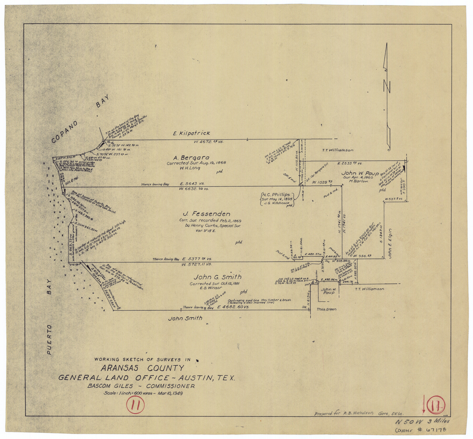
Aransas County Working Sketch 11
-
Map/Doc
67178
-
Collection
General Map Collection
-
Object Dates
3/10/1949 (Creation Date)
-
People and Organizations
Bascom Giles (GLO Commissioner)
W. S. Brewington (Draftsman)
-
Counties
Aransas
-
Subjects
Surveying Working Sketch
-
Height x Width
17.3 x 18.7 inches
43.9 x 47.5 cm
-
Scale
1" = 600 varas
-
Comments
Surveys located about three miles North 50 degrees West of Rockport, Texas.
Part of: General Map Collection
Presidio County Sketch File 70b

Print $6.00
- Digital $50.00
Presidio County Sketch File 70b
Size 11.2 x 8.9 inches
Map/Doc 34671
Flight Mission No. DAG-21K, Frame 132, Matagorda County

Print $20.00
- Digital $50.00
Flight Mission No. DAG-21K, Frame 132, Matagorda County
1952
Size 18.6 x 22.5 inches
Map/Doc 86458
Travis County Sketch File 2

Print $4.00
- Digital $50.00
Travis County Sketch File 2
1851
Size 8.2 x 9.9 inches
Map/Doc 38271
Maps of Gulf Intracoastal Waterway, Texas - Sabine River to the Rio Grande and connecting waterways including ship channels

Print $20.00
- Digital $50.00
Maps of Gulf Intracoastal Waterway, Texas - Sabine River to the Rio Grande and connecting waterways including ship channels
1966
Size 14.3 x 20.8 inches
Map/Doc 61994
Reeves County Working Sketch 43

Print $20.00
- Digital $50.00
Reeves County Working Sketch 43
1974
Size 43.2 x 37.1 inches
Map/Doc 63486
Uvalde County Rolled Sketch B

Print $20.00
- Digital $50.00
Uvalde County Rolled Sketch B
1847
Size 28.8 x 22.4 inches
Map/Doc 8105
Childress County Sketch File 17

Print $8.00
- Digital $50.00
Childress County Sketch File 17
Size 13.0 x 8.2 inches
Map/Doc 18286
Aransas County Sketch File 14

Print $36.00
- Digital $50.00
Aransas County Sketch File 14
1891
Size 14.0 x 8.5 inches
Map/Doc 13128
Starr County Sketch File 18

Print $20.00
- Digital $50.00
Starr County Sketch File 18
1880
Size 38.2 x 25.1 inches
Map/Doc 10606
Knox County Rolled Sketch 17

Print $20.00
- Digital $50.00
Knox County Rolled Sketch 17
1892
Size 31.0 x 39.2 inches
Map/Doc 10670
Burnet County Working Sketch 19

Print $20.00
- Digital $50.00
Burnet County Working Sketch 19
1982
Size 38.2 x 36.7 inches
Map/Doc 67862
Reagan County

Print $40.00
- Digital $50.00
Reagan County
1940
Size 50.5 x 37.7 inches
Map/Doc 78430
You may also like
Flight Mission No. BQR-3K, Frame 161, Brazoria County

Print $20.00
- Digital $50.00
Flight Mission No. BQR-3K, Frame 161, Brazoria County
1952
Size 18.7 x 22.4 inches
Map/Doc 83988
Flight Mission No. CLL-1N, Frame 34, Willacy County

Print $20.00
- Digital $50.00
Flight Mission No. CLL-1N, Frame 34, Willacy County
1954
Size 18.4 x 22.2 inches
Map/Doc 87015
Williamson County Working Sketch Graphic Index

Print $40.00
- Digital $50.00
Williamson County Working Sketch Graphic Index
1946
Size 38.4 x 55.7 inches
Map/Doc 76742
[Surveys in the vicinity of Falls County School Land]
![90168, [Surveys in the vicinity of Falls County School Land], Twichell Survey Records](https://historictexasmaps.com/wmedia_w700/maps/90168-1.tif.jpg)
Print $20.00
- Digital $50.00
[Surveys in the vicinity of Falls County School Land]
Size 32.5 x 37.1 inches
Map/Doc 90168
Flight Mission No. DCL-6C, Frame 6, Kenedy County

Print $20.00
- Digital $50.00
Flight Mission No. DCL-6C, Frame 6, Kenedy County
1943
Size 18.6 x 22.3 inches
Map/Doc 85866
Guadalupe County

Print $20.00
- Digital $50.00
Guadalupe County
1877
Size 21.5 x 21.4 inches
Map/Doc 3608

La Salle County Working Sketch 3

Print $20.00
- Digital $50.00
La Salle County Working Sketch 3
1914
Size 15.0 x 14.2 inches
Map/Doc 70304
Bosque County Sketch File 17

Print $8.00
- Digital $50.00
Bosque County Sketch File 17
1863
Size 13.0 x 7.9 inches
Map/Doc 14788
Menard County Working Sketch 26

Print $20.00
- Digital $50.00
Menard County Working Sketch 26
1961
Size 28.6 x 36.1 inches
Map/Doc 70973
Bowie County Working Sketch 7

Print $20.00
- Digital $50.00
Bowie County Working Sketch 7
1933
Size 25.1 x 12.7 inches
Map/Doc 67411
[Blocks B10 and 6T]
![91511, [Blocks B10 and 6T], Twichell Survey Records](https://historictexasmaps.com/wmedia_w700/maps/91511-1.tif.jpg)
Print $20.00
- Digital $50.00
[Blocks B10 and 6T]
Size 21.0 x 7.5 inches
Map/Doc 91511