Presidio County Sketch File 70b
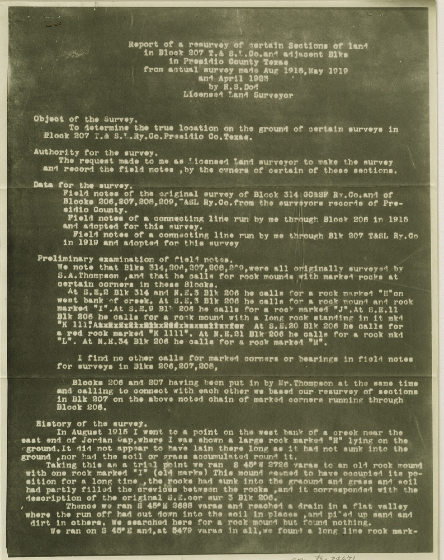
[Report of a resurvey of certain sections of land in Block 207 T.& S.L. Co. and adjacent Blks in Presidio County, Texas]
-
Map/Doc
34671
-
Collection
General Map Collection
-
Object Dates
4/30/1942 (File Date)
8/1915 (Survey Date)
5/1919 (Survey Date)
4/1923 (Survey Date)
-
People and Organizations
R.S. Dod (Surveyor/Engineer)
-
Counties
Presidio
-
Subjects
Surveying Sketch File
-
Height x Width
11.2 x 8.9 inches
28.5 x 22.6 cm
-
Medium
photostat, negative
-
Comments
See Presidio County Sketch File 70a (34669) for sketch.
-
Features
Jordan Gap
Puerta Potrillo Mountain
Related maps
Presidio County Sketch File 70a

Print $6.00
- Digital $50.00
Presidio County Sketch File 70a
1923
Size 17.0 x 11.0 inches
Map/Doc 34669
Part of: General Map Collection
Crockett County Sketch File 61

Print $20.00
- Digital $50.00
Crockett County Sketch File 61
1926
Size 22.0 x 26.0 inches
Map/Doc 11228
Armstrong County Working Sketch 8

Print $20.00
- Digital $50.00
Armstrong County Working Sketch 8
1902
Size 25.4 x 40.2 inches
Map/Doc 67239
Randall County

Print $20.00
- Digital $50.00
Randall County
1917
Size 45.2 x 38.9 inches
Map/Doc 73339
Mills County Sketch File 4a

Print $3.00
- Digital $50.00
Mills County Sketch File 4a
1874
Size 14.5 x 10.1 inches
Map/Doc 31651
Victoria County Sketch File 11

Print $8.00
- Digital $50.00
Victoria County Sketch File 11
1985
Size 11.3 x 9.0 inches
Map/Doc 39536
Presidio County Rolled Sketch 145

Print $20.00
- Digital $50.00
Presidio County Rolled Sketch 145
2012
Size 36.6 x 24.5 inches
Map/Doc 93380
Flight Mission No. DAG-22K, Frame 87, Matagorda County

Print $20.00
- Digital $50.00
Flight Mission No. DAG-22K, Frame 87, Matagorda County
1953
Size 18.6 x 22.4 inches
Map/Doc 86471
Armstrong County Sketch File 2

Print $40.00
- Digital $50.00
Armstrong County Sketch File 2
Size 21.5 x 40.0 inches
Map/Doc 10371
Duval County Rolled Sketch 13

Print $20.00
- Digital $50.00
Duval County Rolled Sketch 13
1937
Size 33.8 x 30.4 inches
Map/Doc 5735
Improving Sabine Pass, Texas. Surveyed May 10th to June 30th, 1894 under the direction of Major James B. Quinn, Corps of Engineers, USA

Print $20.00
- Digital $50.00
Improving Sabine Pass, Texas. Surveyed May 10th to June 30th, 1894 under the direction of Major James B. Quinn, Corps of Engineers, USA
1894
Size 9.3 x 13.2 inches
Map/Doc 94155
Gregg County Working Sketch 3

Print $20.00
- Digital $50.00
Gregg County Working Sketch 3
1931
Size 18.6 x 14.2 inches
Map/Doc 63269
Frio County Sketch File 20

Print $6.00
- Digital $50.00
Frio County Sketch File 20
1964
Size 14.2 x 8.8 inches
Map/Doc 23159
You may also like
Map of Bandera County

Print $20.00
- Digital $50.00
Map of Bandera County
1878
Size 19.3 x 29.4 inches
Map/Doc 3272
Morris County Rolled Sketch 2A

Print $20.00
- Digital $50.00
Morris County Rolled Sketch 2A
Size 24.0 x 18.7 inches
Map/Doc 10286
Hunt County Rolled Sketch 5

Print $20.00
- Digital $50.00
Hunt County Rolled Sketch 5
1956
Size 27.6 x 24.8 inches
Map/Doc 6270
Louisiana and Texas Intracoastal Waterway

Print $20.00
- Digital $50.00
Louisiana and Texas Intracoastal Waterway
1937
Size 13.7 x 19.6 inches
Map/Doc 83348


Liberty County Working Sketch 63

Print $20.00
- Digital $50.00
Liberty County Working Sketch 63
1969
Size 31.3 x 28.7 inches
Map/Doc 70523
Aransas County Rolled Sketch 27C

Print $20.00
- Digital $50.00
Aransas County Rolled Sketch 27C
1979
Size 17.3 x 19.3 inches
Map/Doc 5056
Flight Mission No. BRA-3M, Frame 194, Jefferson County

Print $20.00
- Digital $50.00
Flight Mission No. BRA-3M, Frame 194, Jefferson County
1953
Size 18.8 x 22.4 inches
Map/Doc 85409
Swisher County Rolled Sketch 3

Print $20.00
- Digital $50.00
Swisher County Rolled Sketch 3
Size 21.3 x 19.4 inches
Map/Doc 7904
Orange County Working Sketch 23

Print $20.00
- Digital $50.00
Orange County Working Sketch 23
1940
Size 12.4 x 15.7 inches
Map/Doc 71355
Sketch Showing Railroad through South Seagraves

Print $20.00
- Digital $50.00
Sketch Showing Railroad through South Seagraves
1945
Size 29.1 x 18.4 inches
Map/Doc 92686