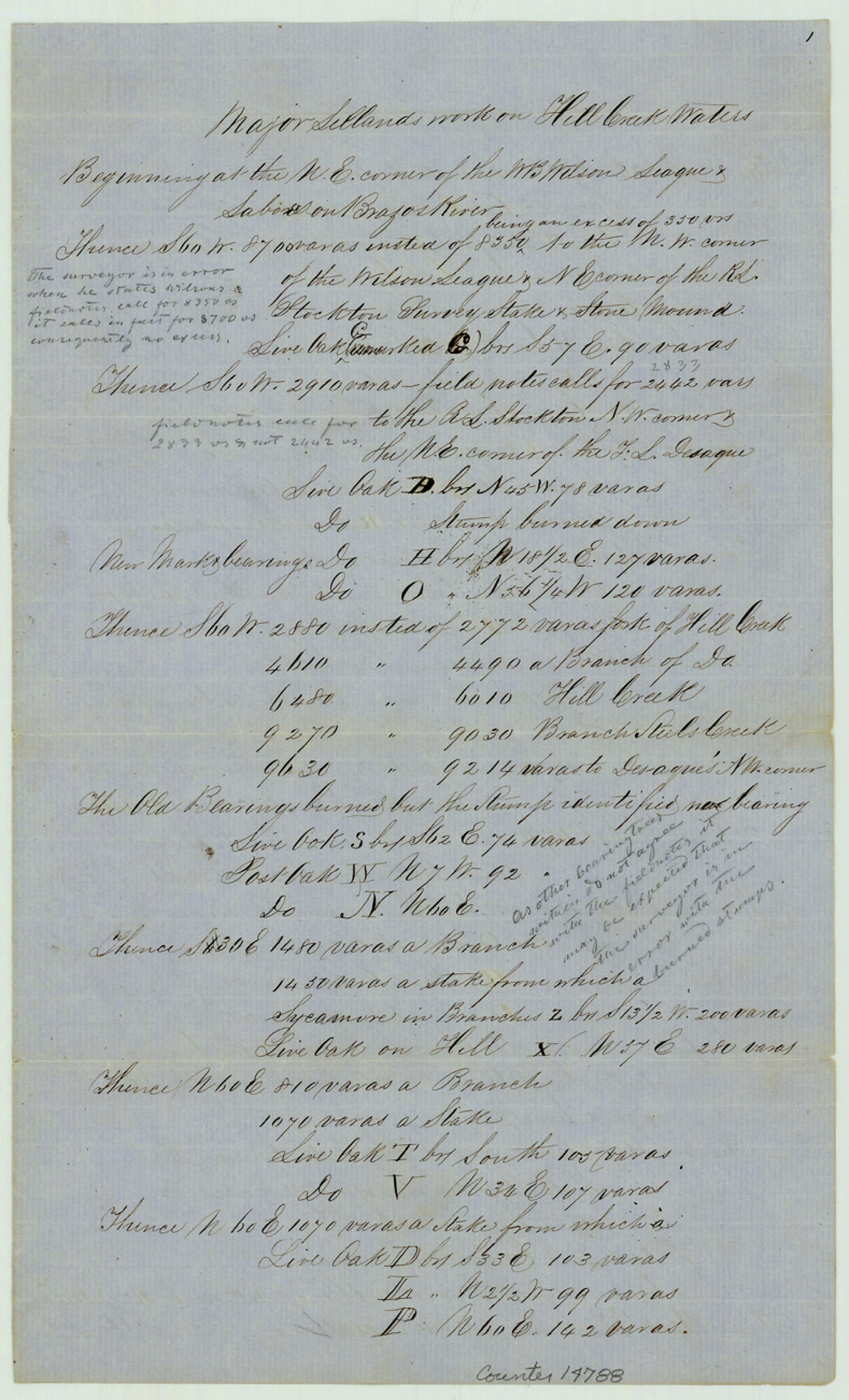
Bosque County Sketch File 17
[Field notes of connection from the north corner of the Wilson league along the Brazos River and southwestwardly]
-
Map/Doc
14788
-
Collection
General Map Collection
-
Object Dates
1863/4/4 (Creation Date)
1863/4/21 (File Date)
-
People and Organizations
J. De Cordova (Surveyor/Engineer)
Henry M. De Cordova (Surveyor/Engineer)
-
Counties
Bosque
-
Subjects
Surveying Sketch File
-
Height x Width
13.0 x 7.9 inches
33.0 x 20.1 cm
-
Medium
paper, manuscript
-
Features
Hill Creek
Brazos River
Steeks Creek
Part of: General Map Collection
Atascosa County Working Sketch 3

Print $20.00
- Digital $50.00
Atascosa County Working Sketch 3
1912
Size 26.3 x 13.2 inches
Map/Doc 67198
Flight Mission No. CLL-3N, Frame 11, Willacy County

Print $20.00
- Digital $50.00
Flight Mission No. CLL-3N, Frame 11, Willacy County
1954
Size 18.6 x 22.3 inches
Map/Doc 87077
Brazoria County Sketch File 38

Print $40.00
- Digital $50.00
Brazoria County Sketch File 38
1917
Size 17.1 x 14.5 inches
Map/Doc 15043
Loving County Rolled Sketch 15

Print $20.00
- Digital $50.00
Loving County Rolled Sketch 15
2015
Size 36.2 x 24.4 inches
Map/Doc 93793
Flight Mission No. DIX-8P, Frame 67, Aransas County

Print $20.00
- Digital $50.00
Flight Mission No. DIX-8P, Frame 67, Aransas County
1956
Size 18.7 x 22.4 inches
Map/Doc 83898
Travis County Working Sketch 21

Print $20.00
- Digital $50.00
Travis County Working Sketch 21
1946
Size 35.6 x 42.7 inches
Map/Doc 69405
Starr County Sketch File 42

Print $20.00
- Digital $50.00
Starr County Sketch File 42
1941
Size 19.0 x 21.6 inches
Map/Doc 12341
Dickens County Sketch File 2

Print $20.00
- Digital $50.00
Dickens County Sketch File 2
1913
Size 22.0 x 32.3 inches
Map/Doc 11316
Upshur County Working Sketch 18

Print $20.00
- Digital $50.00
Upshur County Working Sketch 18
1998
Size 18.1 x 27.7 inches
Map/Doc 69576
Brewster County Rolled Sketch 75

Print $20.00
- Digital $50.00
Brewster County Rolled Sketch 75
1941
Size 31.5 x 36.9 inches
Map/Doc 8492
Upton County Sketch File 27

Print $20.00
- Digital $50.00
Upton County Sketch File 27
1928
Size 42.9 x 22.6 inches
Map/Doc 10416
Menard County Boundary File 6

Print $6.00
- Digital $50.00
Menard County Boundary File 6
Size 11.2 x 8.7 inches
Map/Doc 57086
You may also like
Current Miscellaneous File 15

Print $16.00
- Digital $50.00
Current Miscellaneous File 15
1951
Size 10.7 x 8.2 inches
Map/Doc 73822
Colorado County Working Sketch 9

Print $20.00
- Digital $50.00
Colorado County Working Sketch 9
1939
Size 12.0 x 15.7 inches
Map/Doc 68109
Kerr County State Real Property Sketch 1

Print $20.00
- Digital $50.00
Kerr County State Real Property Sketch 1
2007
Size 24.9 x 35.1 inches
Map/Doc 88669

Scurry County Rolled Sketch 5

Print $40.00
- Digital $50.00
Scurry County Rolled Sketch 5
Size 48.4 x 41.1 inches
Map/Doc 9913
Sterling County Rolled Sketch 35

Print $20.00
- Digital $50.00
Sterling County Rolled Sketch 35
1960
Size 20.8 x 21.8 inches
Map/Doc 7859
Newton County Rolled Sketch 6A

Digital $50.00
Newton County Rolled Sketch 6A
Size 10.3 x 15.4 inches
Map/Doc 46838
Knox County Boundary File 104

Print $10.00
- Digital $50.00
Knox County Boundary File 104
Size 9.2 x 7.4 inches
Map/Doc 65051
Coryell County Working Sketch 28

Print $20.00
- Digital $50.00
Coryell County Working Sketch 28
1990
Size 27.5 x 21.3 inches
Map/Doc 68235
Wise County Sketch File 45

Print $4.00
- Digital $50.00
Wise County Sketch File 45
Size 8.6 x 14.2 inches
Map/Doc 40605
[Map of the dividing line between Milam and Travis Counties]
![110, [Map of the dividing line between Milam and Travis Counties], General Map Collection](https://historictexasmaps.com/wmedia_w700/maps/110.tif.jpg)
Print $20.00
- Digital $50.00
[Map of the dividing line between Milam and Travis Counties]
1841
Size 14.2 x 12.8 inches
Map/Doc 110
Knox County Rolled Sketch 20

Print $20.00
- Digital $50.00
Knox County Rolled Sketch 20
Size 31.5 x 23.3 inches
Map/Doc 6560