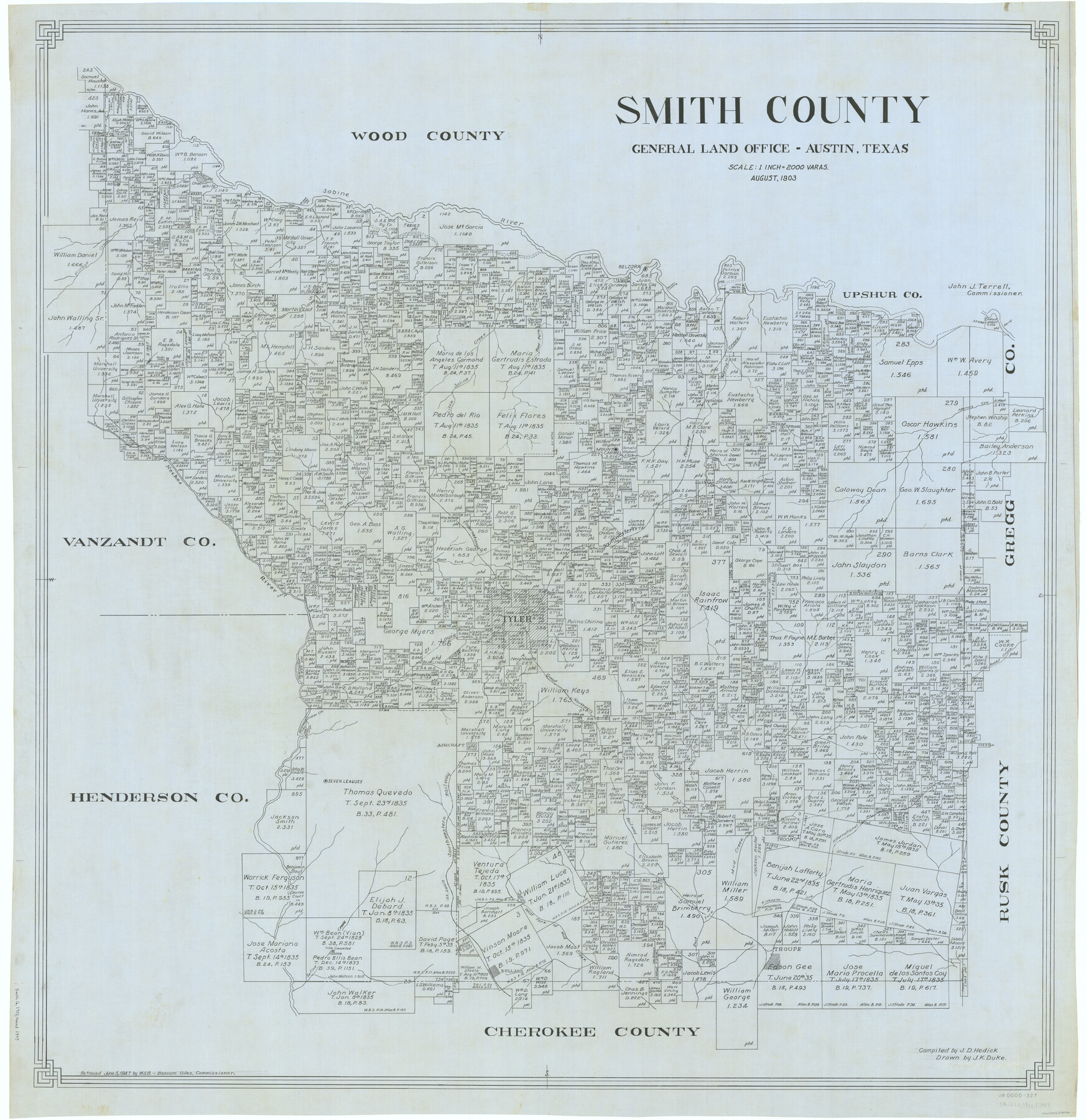
Smith County
-
Map/Doc
63038
-
Collection
General Map Collection
-
Object Dates
1903 (Creation Date)
-
People and Organizations
Texas General Land Office (Publisher)
John D. Hedick (Compiler)
J.K. Duke (Draftsman)
-
Counties
Smith
-
Subjects
County
-
Height x Width
43.6 x 42.3 inches
110.7 x 107.4 cm
-
Comments
Retraced by W. S. B. June 5, 1947.
Part of: General Map Collection
Flight Mission No. CRE-3R, Frame 42, Jackson County

Print $20.00
- Digital $50.00
Flight Mission No. CRE-3R, Frame 42, Jackson County
1956
Size 18.6 x 22.4 inches
Map/Doc 85389
Hudspeth County Sketch File 18

Print $6.00
- Digital $50.00
Hudspeth County Sketch File 18
1935
Size 11.2 x 8.7 inches
Map/Doc 26959
Harris County Sketch File 59a

Print $20.00
- Digital $50.00
Harris County Sketch File 59a
Size 25.1 x 40.1 inches
Map/Doc 10479
Coryell County Working Sketch 26

Print $20.00
- Digital $50.00
Coryell County Working Sketch 26
1988
Size 30.7 x 30.6 inches
Map/Doc 68233
Presidio County Working Sketch 67

Print $20.00
- Digital $50.00
Presidio County Working Sketch 67
1960
Size 36.2 x 36.5 inches
Map/Doc 71744
Culberson County Rolled Sketch 11
Print $20.00
- Digital $50.00
Culberson County Rolled Sketch 11
1898
Size 25.6 x 45.9 inches
Map/Doc 5648
Harrison County Rolled Sketch 2

Print $20.00
- Digital $50.00
Harrison County Rolled Sketch 2
1904
Size 29.9 x 28.0 inches
Map/Doc 6149
Angelina County Sketch File 11f

Print $4.00
- Digital $50.00
Angelina County Sketch File 11f
1885
Size 8.2 x 12.6 inches
Map/Doc 12954
Bandera County Rolled Sketch 13

Print $20.00
- Digital $50.00
Bandera County Rolled Sketch 13
2018
Size 24.1 x 20.5 inches
Map/Doc 95305
Johnson County Working Sketch 10

Print $20.00
- Digital $50.00
Johnson County Working Sketch 10
1953
Size 26.2 x 37.1 inches
Map/Doc 66623
Flight Mission No. BRA-16M, Frame 101, Jefferson County

Print $20.00
- Digital $50.00
Flight Mission No. BRA-16M, Frame 101, Jefferson County
1953
Size 18.6 x 22.4 inches
Map/Doc 85713
La Salle County Working Sketch 19

Print $20.00
- Digital $50.00
La Salle County Working Sketch 19
1941
Size 24.6 x 31.4 inches
Map/Doc 70320
You may also like
Milam County Working Sketch 5

Print $20.00
- Digital $50.00
Milam County Working Sketch 5
1963
Size 29.1 x 23.7 inches
Map/Doc 71020
Kerr County Rolled Sketch 18

Print $20.00
- Digital $50.00
Kerr County Rolled Sketch 18
1954
Size 33.4 x 28.8 inches
Map/Doc 6500
Gillespie County Working Sketch 2

Print $20.00
- Digital $50.00
Gillespie County Working Sketch 2
1958
Size 35.9 x 26.0 inches
Map/Doc 63165
Nolan County Sketch File 13

Print $20.00
- Digital $50.00
Nolan County Sketch File 13
1886
Size 17.8 x 29.9 inches
Map/Doc 42207
[Surveys in the vicinity of the Martina Olivares survey]
![90891, [Surveys in the vicinity of the Martina Olivares survey], Twichell Survey Records](https://historictexasmaps.com/wmedia_w700/maps/90891-1.tif.jpg)
Print $3.00
- Digital $50.00
[Surveys in the vicinity of the Martina Olivares survey]
1911
Size 10.3 x 16.9 inches
Map/Doc 90891
Jefferson County Working Sketch 34

Print $20.00
- Digital $50.00
Jefferson County Working Sketch 34
1981
Size 33.4 x 18.8 inches
Map/Doc 66578
Sylvan Sander's Map of Lubbock, Hockley, and Cochran Counties, Texas

Print $20.00
- Digital $50.00
Sylvan Sander's Map of Lubbock, Hockley, and Cochran Counties, Texas
1925
Size 43.6 x 21.8 inches
Map/Doc 92611
Runnels County Rolled Sketch 43

Print $20.00
- Digital $50.00
Runnels County Rolled Sketch 43
Size 28.3 x 45.8 inches
Map/Doc 7531

Val Verde County Rolled Sketch 28

Print $20.00
- Digital $50.00
Val Verde County Rolled Sketch 28
Size 28.5 x 36.1 inches
Map/Doc 8110
Pecos County Rolled Sketch 111

Print $20.00
- Digital $50.00
Pecos County Rolled Sketch 111
1941
Size 30.0 x 20.9 inches
Map/Doc 7256
W. L. Ellwood's O Ranch, Lubbock and Hockley Co.

Print $20.00
- Digital $50.00
W. L. Ellwood's O Ranch, Lubbock and Hockley Co.
Size 15.5 x 23.8 inches
Map/Doc 92762