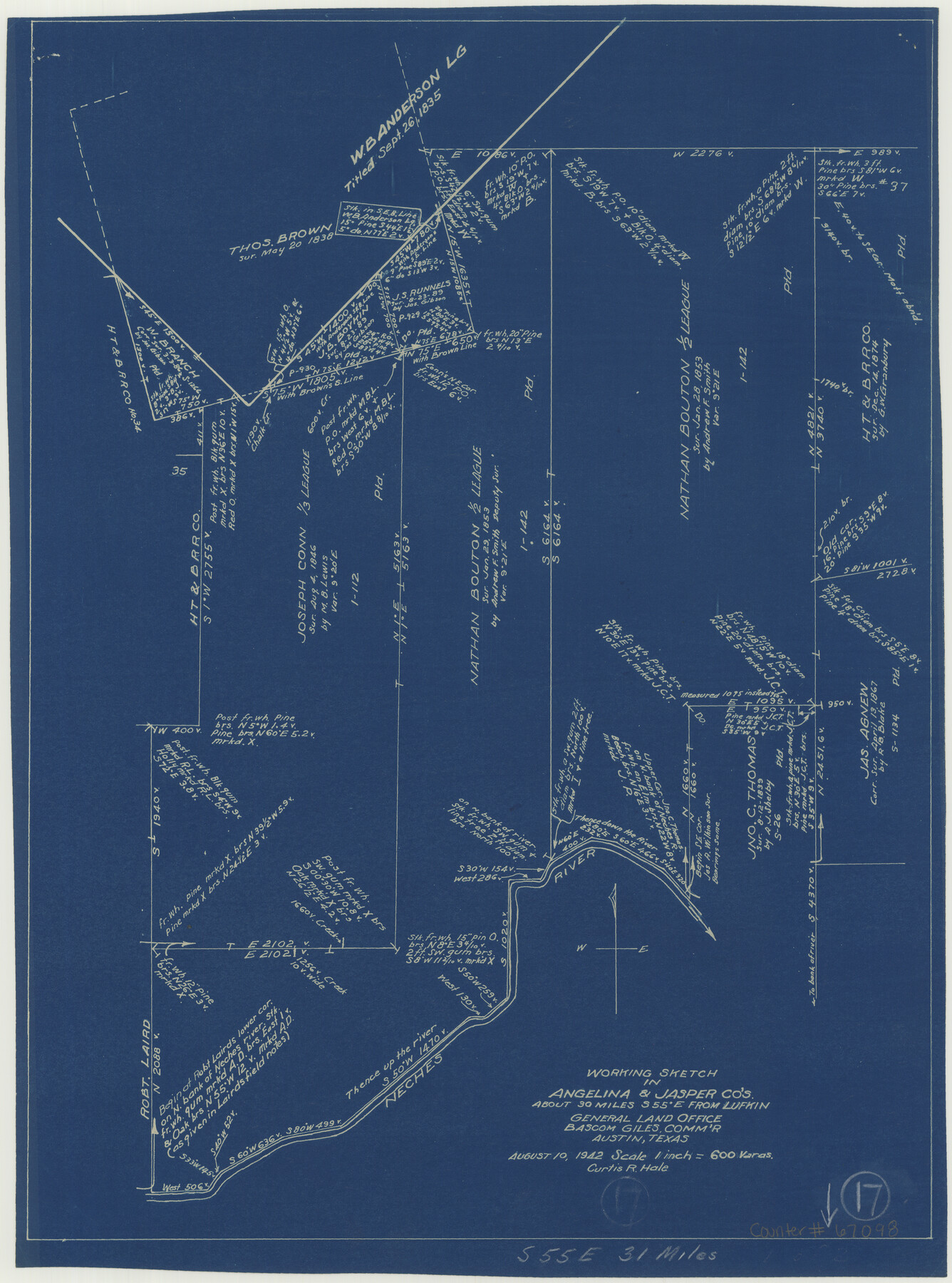
Angelina County Working Sketch 17
-
Map/Doc
67098
-
Collection
General Map Collection
-
Object Dates
8/10/1942 (Creation Date)
-
People and Organizations
Curtis R. Hale (Draftsman)
-
Counties
Angelina Jasper
-
Subjects
Surveying Working Sketch
-
Height x Width
18.6 x 13.8 inches
47.2 x 35.1 cm
-
Scale
1" = 600 varas
-
Comments
Surveys located about 30 miles South 55 degrees East from Lufkin, Texas.
Part of: General Map Collection

East Part of Jeff Davis Co.

Print $20.00
- Digital $50.00
East Part of Jeff Davis Co.
1977
Size 47.9 x 36.9 inches
Map/Doc 95544
Jefferson County Sketch File 46

Print $20.00
- Digital $50.00
Jefferson County Sketch File 46
1933
Size 20.8 x 31.2 inches
Map/Doc 11880
Johnson County Working Sketch 17

Print $40.00
- Digital $50.00
Johnson County Working Sketch 17
1985
Size 48.3 x 44.4 inches
Map/Doc 66630
[Gulf, Colorado & Santa Fe]
![64592, [Gulf, Colorado & Santa Fe], General Map Collection](https://historictexasmaps.com/wmedia_w700/maps/64592.tif.jpg)
Print $40.00
- Digital $50.00
[Gulf, Colorado & Santa Fe]
1918
Size 33.2 x 110.5 inches
Map/Doc 64592
Hamilton County Boundary File 1

Print $22.00
- Digital $50.00
Hamilton County Boundary File 1
Size 8.6 x 8.1 inches
Map/Doc 54183
Panola County Working Sketch 37

Print $20.00
- Digital $50.00
Panola County Working Sketch 37
1984
Map/Doc 71446
Uvalde County Sketch File 8

Print $6.00
- Digital $50.00
Uvalde County Sketch File 8
1882
Size 8.4 x 6.2 inches
Map/Doc 38964
Eastland County Working Sketch 35

Print $20.00
- Digital $50.00
Eastland County Working Sketch 35
1962
Size 24.0 x 21.6 inches
Map/Doc 68816
Robertson County Working Sketch 12

Print $20.00
- Digital $50.00
Robertson County Working Sketch 12
1984
Size 20.6 x 22.4 inches
Map/Doc 63585

San Luis Pass to East Matagorda Bay

Print $40.00
- Digital $50.00
San Luis Pass to East Matagorda Bay
1991
Size 35.0 x 48.8 inches
Map/Doc 69972
You may also like
Anderson County Sketch File 16

Print $6.00
- Digital $50.00
Anderson County Sketch File 16
1849
Size 8.6 x 6.5 inches
Map/Doc 12783
Stonewall County Working Sketch 14

Print $20.00
- Digital $50.00
Stonewall County Working Sketch 14
1951
Size 22.2 x 37.1 inches
Map/Doc 62321
Brewster County Rolled Sketch 22F

Print $20.00
- Digital $50.00
Brewster County Rolled Sketch 22F
1909
Size 19.0 x 25.4 inches
Map/Doc 5206
General Highway Map, Kenedy County, Texas

Print $20.00
General Highway Map, Kenedy County, Texas
1961
Size 18.0 x 24.6 inches
Map/Doc 79446
J. De Cordova's Map of the State of Texas Compiled from the records of the General Land Office of the State

Print $20.00
- Digital $50.00
J. De Cordova's Map of the State of Texas Compiled from the records of the General Land Office of the State
Size 38.5 x 36.4 inches
Map/Doc 93984
Trinity River, Porters Bluff Sheet

Print $20.00
- Digital $50.00
Trinity River, Porters Bluff Sheet
1925
Size 27.4 x 23.6 inches
Map/Doc 69689
Wichita County Sketch File 8

Print $4.00
- Digital $50.00
Wichita County Sketch File 8
1860
Size 11.7 x 8.2 inches
Map/Doc 40048
Garza County Sketch File D

Print $20.00
- Digital $50.00
Garza County Sketch File D
1901
Size 18.4 x 12.2 inches
Map/Doc 11550
Val Verde Co.

Print $20.00
- Digital $50.00
Val Verde Co.
1908
Size 41.2 x 37.3 inches
Map/Doc 78447
Jasper County Sketch File 29

Print $20.00
- Digital $50.00
Jasper County Sketch File 29
1947
Size 21.0 x 24.8 inches
Map/Doc 11851
Somervell County

Print $20.00
- Digital $50.00
Somervell County
1884
Size 25.1 x 24.2 inches
Map/Doc 4042
Pecos County Working Sketch 34

Print $20.00
- Digital $50.00
Pecos County Working Sketch 34
1939
Size 32.7 x 27.6 inches
Map/Doc 71506