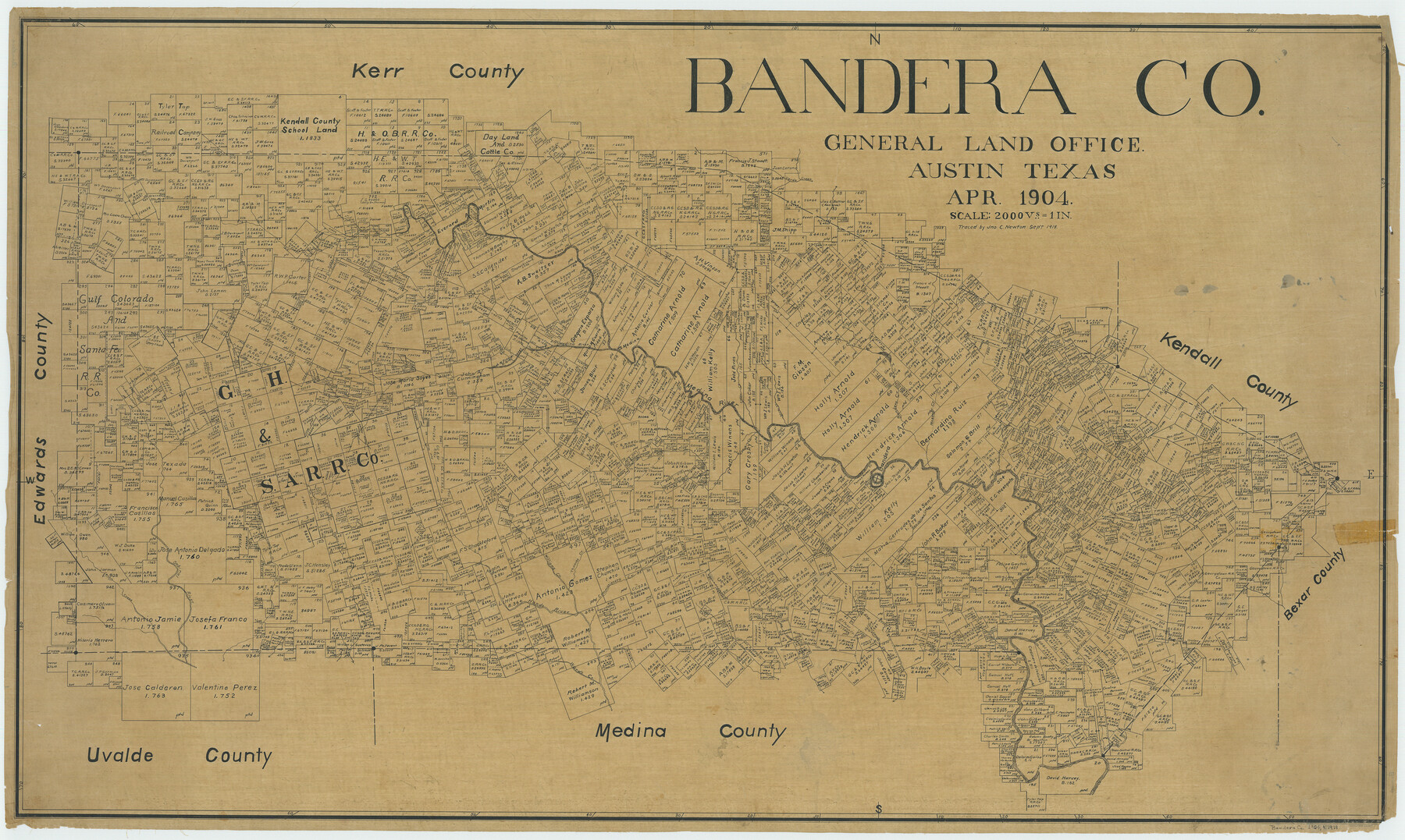
Bandera Co.
-
Map/Doc
66709
-
Collection
General Map Collection
-
Object Dates
1904 (Creation Date)
-
People and Organizations
Texas General Land Office (Publisher)
-
Counties
Bandera
-
Subjects
County
-
Height x Width
31.3 x 52.3 inches
79.5 x 132.8 cm
-
Comments
Traced in September 1918 by Jno. C. Newton.
Part of: General Map Collection
Gaines County Rolled Sketch 14A

Print $40.00
- Digital $50.00
Gaines County Rolled Sketch 14A
1940
Size 24.8 x 129.0 inches
Map/Doc 9031
Hemphill County Working Sketch 18

Print $20.00
- Digital $50.00
Hemphill County Working Sketch 18
1972
Size 33.7 x 41.6 inches
Map/Doc 66113
Middle Sulphur and South Sulphur Rivers, Horton Sheet

Print $20.00
- Digital $50.00
Middle Sulphur and South Sulphur Rivers, Horton Sheet
1925
Size 25.6 x 22.0 inches
Map/Doc 78330
Coryell County Sketch File 4

Print $6.00
- Digital $50.00
Coryell County Sketch File 4
1854
Size 12.8 x 8.2 inches
Map/Doc 19342
Culberson County Rolled Sketch 50

Print $20.00
- Digital $50.00
Culberson County Rolled Sketch 50
1963
Size 19.3 x 25.0 inches
Map/Doc 5669
Flight Mission No. DQO-2K, Frame 165, Galveston County

Print $20.00
- Digital $50.00
Flight Mission No. DQO-2K, Frame 165, Galveston County
1952
Size 18.9 x 22.4 inches
Map/Doc 85054
Jack County Sketch File 36

Print $120.00
- Digital $50.00
Jack County Sketch File 36
1882
Size 16.3 x 11.0 inches
Map/Doc 27575
Galveston County Sketch File 2

Print $2.00
- Digital $50.00
Galveston County Sketch File 2
1845
Size 8.3 x 11.1 inches
Map/Doc 23349
Intracoastal Waterway in Texas - Corpus Christi to Point Isabel including Arroyo Colorado to Mo. Pac. R.R. Bridge Near Harlingen

Print $20.00
- Digital $50.00
Intracoastal Waterway in Texas - Corpus Christi to Point Isabel including Arroyo Colorado to Mo. Pac. R.R. Bridge Near Harlingen
1934
Size 21.8 x 32.7 inches
Map/Doc 61885
Calhoun County NRC Article 33.136 Location Key Sheet

Print $20.00
- Digital $50.00
Calhoun County NRC Article 33.136 Location Key Sheet
1973
Size 27.0 x 23.0 inches
Map/Doc 87907
Gillespie County Boundary File 5

Print $10.00
- Digital $50.00
Gillespie County Boundary File 5
Size 14.2 x 9.0 inches
Map/Doc 53764
Marion County Working Sketch 22

Print $20.00
- Digital $50.00
Marion County Working Sketch 22
1960
Size 34.3 x 27.5 inches
Map/Doc 70798
You may also like
Dimmit County Sketch File 19 1/2a

Print $12.00
- Digital $50.00
Dimmit County Sketch File 19 1/2a
1887
Size 14.2 x 8.8 inches
Map/Doc 21094
Orange County Sketch File 29

Print $4.00
- Digital $50.00
Orange County Sketch File 29
1922
Size 11.2 x 8.8 inches
Map/Doc 33358
A New and Correct County Map of the State of Texas

Print $20.00
- Digital $50.00
A New and Correct County Map of the State of Texas
1891
Size 22.4 x 27.3 inches
Map/Doc 95760
Bosque County Boundary File 1

Print $34.00
- Digital $50.00
Bosque County Boundary File 1
Size 10.7 x 8.2 inches
Map/Doc 50672
Current Miscellaneous File 48

Print $32.00
- Digital $50.00
Current Miscellaneous File 48
Size 11.2 x 8.7 inches
Map/Doc 73996
Culberson County Working Sketch 51

Print $40.00
- Digital $50.00
Culberson County Working Sketch 51
1972
Size 65.0 x 34.0 inches
Map/Doc 68505
Matagorda County Sketch File 14

Print $40.00
- Digital $50.00
Matagorda County Sketch File 14
Size 13.5 x 14.8 inches
Map/Doc 30772
Anderson County Rolled Sketch 8

Print $20.00
- Digital $50.00
Anderson County Rolled Sketch 8
Size 34.8 x 23.9 inches
Map/Doc 77154
General Highway Map, Live Oak County, Texas

Print $20.00
General Highway Map, Live Oak County, Texas
1940
Size 18.4 x 24.8 inches
Map/Doc 79177
Angelina County Working Sketch 24

Print $20.00
- Digital $50.00
Angelina County Working Sketch 24
1954
Size 27.0 x 23.0 inches
Map/Doc 67106
[H. & T. C. Block 47 and vicinity]
![91171, [H. & T. C. Block 47 and vicinity], Twichell Survey Records](https://historictexasmaps.com/wmedia_w700/maps/91171-1.tif.jpg)
Print $20.00
- Digital $50.00
[H. & T. C. Block 47 and vicinity]
1891
Size 19.4 x 15.3 inches
Map/Doc 91171
Stephens County Working Sketch 6

Print $20.00
- Digital $50.00
Stephens County Working Sketch 6
1919
Size 13.1 x 22.0 inches
Map/Doc 63949