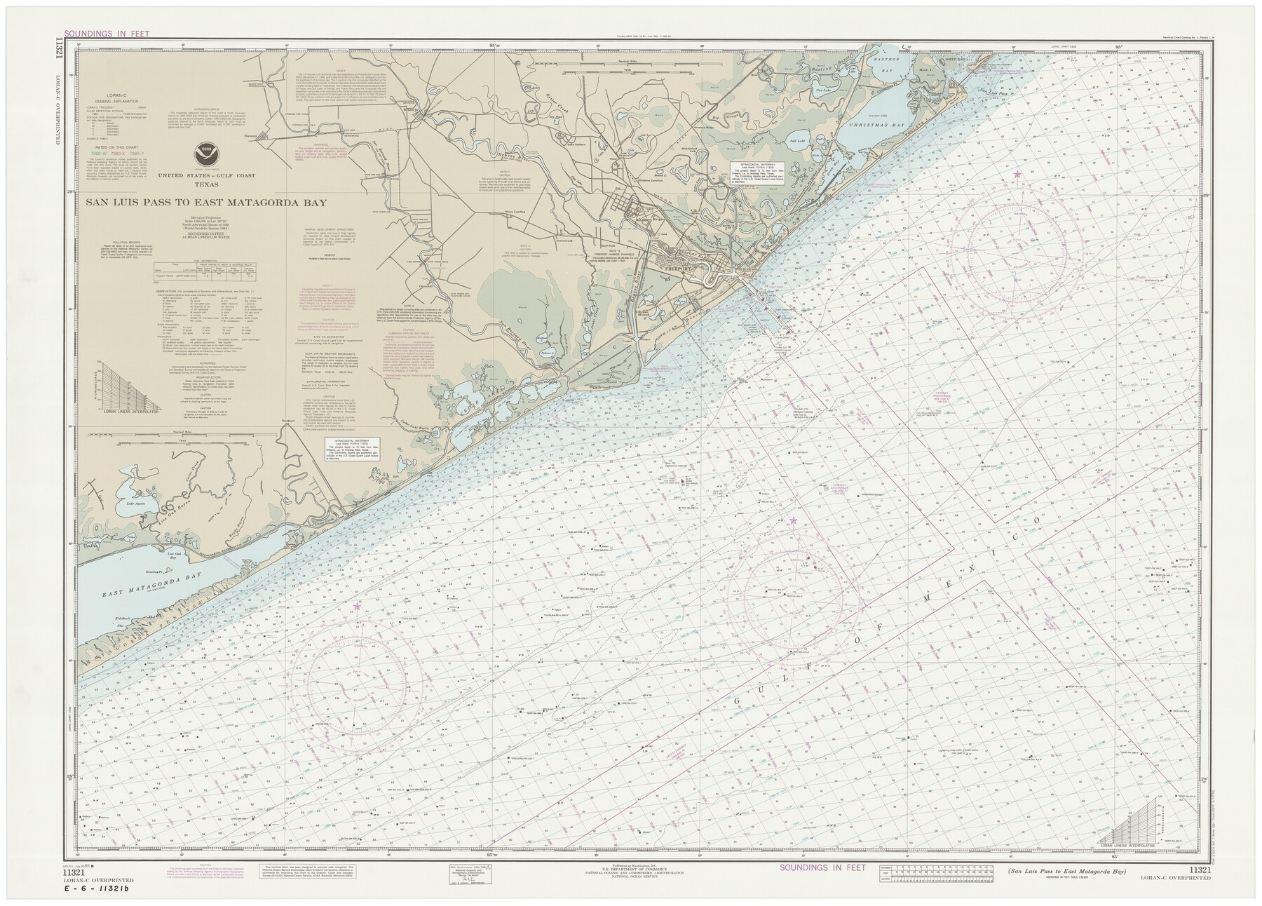
San Luis Pass to East Matagorda Bay
K-6-1283d
-
Map/Doc
69972
-
Collection
General Map Collection
-
Object Dates
7/20/1991 (Creation Date)
-
Counties
Galveston Matagorda Brazoria
-
Subjects
Nautical Charts
-
Height x Width
35.0 x 48.8 inches
88.9 x 124.0 cm
Part of: General Map Collection
Map of Runnels County

Print $20.00
- Digital $50.00
Map of Runnels County
1858
Size 24.7 x 25.6 inches
Map/Doc 4004
Johnson County

Print $20.00
- Digital $50.00
Johnson County
1874
Size 19.9 x 18.0 inches
Map/Doc 3736
Flight Mission No. DCL-7C, Frame 51, Kenedy County

Print $20.00
- Digital $50.00
Flight Mission No. DCL-7C, Frame 51, Kenedy County
1943
Size 16.6 x 16.4 inches
Map/Doc 86039
Pecos County Working Sketch 9

Print $20.00
- Digital $50.00
Pecos County Working Sketch 9
1907
Size 32.4 x 26.7 inches
Map/Doc 71479
McCulloch County Sketch File 14

Print $8.00
- Digital $50.00
McCulloch County Sketch File 14
1990
Size 11.2 x 8.7 inches
Map/Doc 31203
Current Miscellaneous File 36

Print $12.00
- Digital $50.00
Current Miscellaneous File 36
Size 10.3 x 12.4 inches
Map/Doc 73952
Armstrong County Working Sketch 11

Print $20.00
- Digital $50.00
Armstrong County Working Sketch 11
2025
Map/Doc 97507
Flight Mission No. DQN-2K, Frame 90, Calhoun County

Print $20.00
- Digital $50.00
Flight Mission No. DQN-2K, Frame 90, Calhoun County
1953
Size 18.4 x 22.3 inches
Map/Doc 84280
Grayson County Working Sketch 10

Print $20.00
- Digital $50.00
Grayson County Working Sketch 10
1951
Size 41.6 x 37.8 inches
Map/Doc 63249
Crosby County Working Sketch 9

Print $20.00
- Digital $50.00
Crosby County Working Sketch 9
1943
Size 19.8 x 35.2 inches
Map/Doc 68443
Map of Houston, Harris County, Texas

Print $20.00
- Digital $50.00
Map of Houston, Harris County, Texas
1900
Size 38.5 x 32.0 inches
Map/Doc 93390
Jefferson County Sketch File 37

Print $20.00
- Digital $50.00
Jefferson County Sketch File 37
Size 22.3 x 32.4 inches
Map/Doc 11875
You may also like
[Surveyor's certificate by James Howlet, District Surveyor]
![318, [Surveyor's certificate by James Howlet, District Surveyor], General Map Collection](https://historictexasmaps.com/wmedia_w700/maps/318.tif.jpg)
Print $2.00
- Digital $50.00
[Surveyor's certificate by James Howlet, District Surveyor]
Size 6.1 x 8.0 inches
Map/Doc 318
Sketch in Crockett County [showing University Land Blocks 42 and 45 and Block A-B]
![90313, Sketch in Crockett County [showing University Land Blocks 42 and 45 and Block A-B], Twichell Survey Records](https://historictexasmaps.com/wmedia_w700/maps/90313-1.tif.jpg)
Print $20.00
- Digital $50.00
Sketch in Crockett County [showing University Land Blocks 42 and 45 and Block A-B]
1913
Size 24.6 x 11.9 inches
Map/Doc 90313
Refugio County Sketch File 17

Print $6.00
- Digital $50.00
Refugio County Sketch File 17
1902
Size 14.3 x 8.8 inches
Map/Doc 35272

[Marion County, Texas]
![75777, [Marion County, Texas], Maddox Collection](https://historictexasmaps.com/wmedia_w700/maps/75777.tif.jpg)
Print $20.00
- Digital $50.00
[Marion County, Texas]
1901
Size 26.5 x 24.1 inches
Map/Doc 75777
Crosby County Sketch File 1b

Print $20.00
- Digital $50.00
Crosby County Sketch File 1b
Size 18.0 x 14.5 inches
Map/Doc 11244
Map of the Fort Worth and Denver City Railway

Print $40.00
- Digital $50.00
Map of the Fort Worth and Denver City Railway
1873
Size 31.6 x 90.3 inches
Map/Doc 64778
Crockett County Working Sketch 9

Print $20.00
- Digital $50.00
Crockett County Working Sketch 9
1912
Size 24.2 x 32.1 inches
Map/Doc 68342
Chambers County Boundary File 50a

Print $40.00
- Digital $50.00
Chambers County Boundary File 50a
Size 22.2 x 17.1 inches
Map/Doc 51270
Lavaca County Working Sketch 11

Print $20.00
- Digital $50.00
Lavaca County Working Sketch 11
1954
Size 34.0 x 28.3 inches
Map/Doc 70364
Galveston County Sketch File 33

Print $12.00
- Digital $50.00
Galveston County Sketch File 33
1934
Size 11.2 x 8.8 inches
Map/Doc 23413
Liberty County Rolled Sketch JP2

Print $40.00
- Digital $50.00
Liberty County Rolled Sketch JP2
1935
Size 52.2 x 12.7 inches
Map/Doc 81403