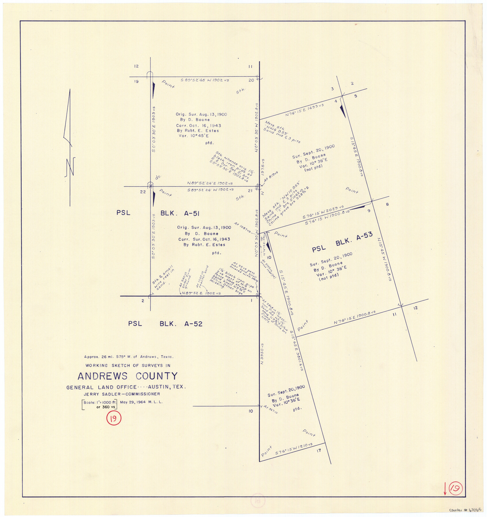
Andrews County Working Sketch 19
-
Map/Doc
67065
-
Collection
General Map Collection
-
Object Dates
5/29/1964 (Creation Date)
-
People and Organizations
Jerry Sadler (GLO Commissioner)
M. L. Liles (Draftsman)
-
Counties
Andrews
-
Subjects
Surveying Working Sketch
-
Height x Width
24.9 x 23.5 inches
63.3 x 59.7 cm
-
Scale
1" = 360 varas
-
Comments
Surveys located about 26 miles South 75 degrees West of Andrews, Texas.
Part of: General Map Collection
Flight Mission No. BRA-8M, Frame 135, Jefferson County

Print $20.00
- Digital $50.00
Flight Mission No. BRA-8M, Frame 135, Jefferson County
1953
Size 18.7 x 22.3 inches
Map/Doc 85631
Galveston County Rolled Sketch S

Print $20.00
- Digital $50.00
Galveston County Rolled Sketch S
1935
Size 36.0 x 46.8 inches
Map/Doc 9088
Newton County Working Sketch 12

Print $20.00
- Digital $50.00
Newton County Working Sketch 12
1942
Size 24.5 x 28.5 inches
Map/Doc 71258
Flight Mission No. CUG-2P, Frame 82, Kleberg County

Print $20.00
- Digital $50.00
Flight Mission No. CUG-2P, Frame 82, Kleberg County
1956
Size 18.5 x 22.3 inches
Map/Doc 86214
Flight Mission No. BRE-2P, Frame 75, Nueces County

Print $20.00
- Digital $50.00
Flight Mission No. BRE-2P, Frame 75, Nueces County
1956
Size 18.5 x 22.5 inches
Map/Doc 86770
[Beaumont, Sour Lake and Western Ry. Right of Way and Alignment - Frisco]
![64110, [Beaumont, Sour Lake and Western Ry. Right of Way and Alignment - Frisco], General Map Collection](https://historictexasmaps.com/wmedia_w700/maps/64110.tif.jpg)
Print $20.00
- Digital $50.00
[Beaumont, Sour Lake and Western Ry. Right of Way and Alignment - Frisco]
1910
Size 20.2 x 46.3 inches
Map/Doc 64110
Cass County Working Sketch 39

Print $20.00
- Digital $50.00
Cass County Working Sketch 39
1983
Size 26.3 x 34.6 inches
Map/Doc 67942
Comal County Working Sketch 18

Print $20.00
- Digital $50.00
Comal County Working Sketch 18
2000
Size 32.0 x 31.7 inches
Map/Doc 68182
Kinney County Working Sketch 33

Print $20.00
- Digital $50.00
Kinney County Working Sketch 33
1962
Size 39.0 x 44.2 inches
Map/Doc 70215
Wilbarger County Working Sketch 8

Print $20.00
- Digital $50.00
Wilbarger County Working Sketch 8
1948
Size 31.8 x 38.2 inches
Map/Doc 72546
Sketch showing progress of topographical work Laguna Madre and vicinity from Rainey Is. to Baffins Bay, Coast of Texas Sect. IX [and accompanying letter]
![72958, Sketch showing progress of topographical work Laguna Madre and vicinity from Rainey Is. to Baffins Bay, Coast of Texas Sect. IX [and accompanying letter], General Map Collection](https://historictexasmaps.com/wmedia_w700/maps/72958.tif.jpg)
Print $2.00
- Digital $50.00
Sketch showing progress of topographical work Laguna Madre and vicinity from Rainey Is. to Baffins Bay, Coast of Texas Sect. IX [and accompanying letter]
1881
Size 11.2 x 8.8 inches
Map/Doc 72958
Padre Island National Seashore, Texas - Dependent Resurvey

Print $4.00
- Digital $50.00
Padre Island National Seashore, Texas - Dependent Resurvey
2001
Size 18.2 x 24.3 inches
Map/Doc 60552
You may also like
Working Sketch in Gray, Donley, and Carson Counties, Texas

Print $20.00
- Digital $50.00
Working Sketch in Gray, Donley, and Carson Counties, Texas
1909
Size 22.7 x 27.0 inches
Map/Doc 90779
Jefferson County Rolled Sketch 41

Print $20.00
- Digital $50.00
Jefferson County Rolled Sketch 41
1897
Size 17.6 x 25.4 inches
Map/Doc 6400

[Surveys along the Neches River in Jasper District]
![69733, [Surveys along the Neches River in Jasper District], General Map Collection](https://historictexasmaps.com/wmedia_w700/maps/69733.tif.jpg)
Print $2.00
- Digital $50.00
[Surveys along the Neches River in Jasper District]
1847
Size 9.2 x 6.8 inches
Map/Doc 69733
University Lands as resurveyed by Frank F. Friend, Special Surveyor, San Angelo, Texas projected on a map of the State of Texas

Print $40.00
- Digital $50.00
University Lands as resurveyed by Frank F. Friend, Special Surveyor, San Angelo, Texas projected on a map of the State of Texas
1936
Size 31.0 x 55.8 inches
Map/Doc 2418
Sketch in Cochran County, Texas

Print $20.00
- Digital $50.00
Sketch in Cochran County, Texas
1949
Size 21.8 x 21.0 inches
Map/Doc 92495
Presidio County Rolled Sketch 53

Print $20.00
- Digital $50.00
Presidio County Rolled Sketch 53
1911
Size 14.3 x 21.7 inches
Map/Doc 7345
[County Line, Roberts and Hutchinson County]
![91184, [County Line, Roberts and Hutchinson County], Twichell Survey Records](https://historictexasmaps.com/wmedia_w700/maps/91184-1.tif.jpg)
Print $20.00
- Digital $50.00
[County Line, Roberts and Hutchinson County]
1907
Size 33.7 x 7.7 inches
Map/Doc 91184
J. De Cordova's Map of the State of Texas Compiled from the records of the General Land Office of the State

Print $2.00
- Digital $50.00
J. De Cordova's Map of the State of Texas Compiled from the records of the General Land Office of the State
1855
Size 6.8 x 4.0 inches
Map/Doc 93912
Presidio County Working Sketch 27

Print $20.00
- Digital $50.00
Presidio County Working Sketch 27
1945
Size 32.4 x 13.4 inches
Map/Doc 71703
Burnet County Working Sketch 15

Print $20.00
- Digital $50.00
Burnet County Working Sketch 15
1979
Size 38.2 x 30.4 inches
Map/Doc 67858
Flight Mission No. DQN-1K, Frame 119, Calhoun County

Print $20.00
- Digital $50.00
Flight Mission No. DQN-1K, Frame 119, Calhoun County
1953
Size 18.6 x 22.1 inches
Map/Doc 84185