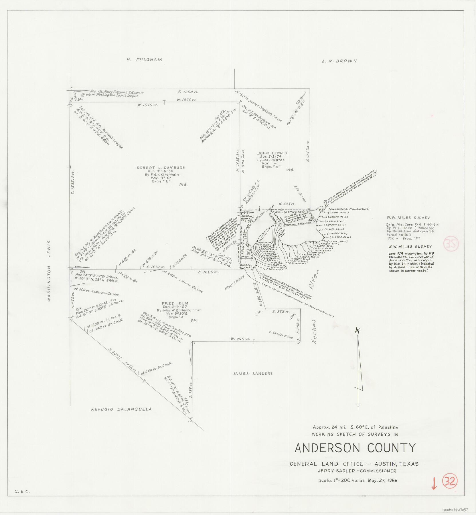
Anderson County Working Sketch 32
-
Map/Doc
67032
-
Collection
General Map Collection
-
Object Dates
5/27/1966 (Creation Date)
-
People and Organizations
Jerry Sadler (GLO Commissioner)
-
Counties
Anderson
-
Subjects
Surveying Working Sketch
-
Height x Width
23.7 x 21.9 inches
60.2 x 55.6 cm
-
Scale
1" = 200 varas
-
Comments
Surveys located about 24 miles South 60 degrees East of Palestine, Texas.
Part of: General Map Collection
Reeves County Rolled Sketch 27

Print $20.00
- Digital $50.00
Reeves County Rolled Sketch 27
1985
Size 21.6 x 27.6 inches
Map/Doc 7496
Tom Green County Sketch File 37

Print $2.00
- Digital $50.00
Tom Green County Sketch File 37
Size 9.4 x 8.5 inches
Map/Doc 38195
Old Miscellaneous File 2

Print $16.00
- Digital $50.00
Old Miscellaneous File 2
1838
Size 13.0 x 8.0 inches
Map/Doc 75406
Houston County Sketch File 23

Print $6.00
- Digital $50.00
Houston County Sketch File 23
1852
Size 6.5 x 5.2 inches
Map/Doc 26793
Morris County Rolled Sketch 2A

Print $20.00
- Digital $50.00
Morris County Rolled Sketch 2A
Size 22.5 x 17.6 inches
Map/Doc 10230
Robertson County Working Sketch 8

Print $20.00
- Digital $50.00
Robertson County Working Sketch 8
1983
Size 36.7 x 38.7 inches
Map/Doc 63581
Kleberg County Rolled Sketch 10-30

Print $20.00
- Digital $50.00
Kleberg County Rolled Sketch 10-30
1952
Size 35.3 x 38.0 inches
Map/Doc 9400
Upton County Rolled Sketch 3

Print $20.00
- Digital $50.00
Upton County Rolled Sketch 3
Size 30.3 x 34.1 inches
Map/Doc 8066

Traced from Genl. Arista's map captured by the American Army under Genl. Taylor at Resaca de la Palma 9th May '46 and presented to James K. Polk, President U. States

Print $20.00
- Digital $50.00
Traced from Genl. Arista's map captured by the American Army under Genl. Taylor at Resaca de la Palma 9th May '46 and presented to James K. Polk, President U. States
1846
Size 18.2 x 27.4 inches
Map/Doc 73061
Brewster County Working Sketch 12

Print $20.00
- Digital $50.00
Brewster County Working Sketch 12
1924
Size 36.9 x 21.4 inches
Map/Doc 67545
Matagorda County Aerial Photograph Index Sheet 7

Print $20.00
- Digital $50.00
Matagorda County Aerial Photograph Index Sheet 7
1953
Size 23.7 x 19.7 inches
Map/Doc 83728
You may also like
Crockett County Working Sketch 53

Print $20.00
- Digital $50.00
Crockett County Working Sketch 53
1948
Size 24.2 x 27.7 inches
Map/Doc 68386
General Highway Map. Detail of Cities and Towns in McLennan County, Texas [Waco and vicinity]
![79192, General Highway Map. Detail of Cities and Towns in McLennan County, Texas [Waco and vicinity], Texas State Library and Archives](https://historictexasmaps.com/wmedia_w700/maps/79192.tif.jpg)
Print $20.00
General Highway Map. Detail of Cities and Towns in McLennan County, Texas [Waco and vicinity]
1940
Size 18.2 x 24.7 inches
Map/Doc 79192
Potter County Sketch File 23

Print $4.00
- Digital $50.00
Potter County Sketch File 23
Size 11.1 x 8.7 inches
Map/Doc 34421
[Gulf Coast portion of] Map of the State of Texas
![72706, [Gulf Coast portion of] Map of the State of Texas, General Map Collection](https://historictexasmaps.com/wmedia_w700/maps/72706.tif.jpg)
Print $20.00
- Digital $50.00
[Gulf Coast portion of] Map of the State of Texas
1865
Size 27.2 x 18.2 inches
Map/Doc 72706
Montgomery County Working Sketch 63

Print $20.00
- Digital $50.00
Montgomery County Working Sketch 63
1964
Size 31.6 x 36.7 inches
Map/Doc 71170
Flight Mission No. CRC-2R, Frame 1, Chambers County

Print $20.00
- Digital $50.00
Flight Mission No. CRC-2R, Frame 1, Chambers County
1956
Size 18.7 x 22.5 inches
Map/Doc 84720
Kent County Working Sketch 7

Print $20.00
- Digital $50.00
Kent County Working Sketch 7
1952
Size 32.7 x 23.7 inches
Map/Doc 70014
Flight Mission No. DCL-5C, Frame 68, Kenedy County

Print $20.00
- Digital $50.00
Flight Mission No. DCL-5C, Frame 68, Kenedy County
1943
Size 18.6 x 22.4 inches
Map/Doc 85851
Travis County Working Sketch 42

Print $20.00
- Digital $50.00
Travis County Working Sketch 42
1974
Size 32.5 x 35.2 inches
Map/Doc 69426
Navarro County Sketch File 5

Print $6.00
- Digital $50.00
Navarro County Sketch File 5
1852
Size 5.5 x 8.1 inches
Map/Doc 32307
Brewster County Sketch File 57

Print $6.00
- Digital $50.00
Brewster County Sketch File 57
2008
Size 11.0 x 8.5 inches
Map/Doc 88871
[Galveston, Harrisburg & San Antonio Railway]
![64408, [Galveston, Harrisburg & San Antonio Railway], General Map Collection](https://historictexasmaps.com/wmedia_w700/maps/64408.tif.jpg)
Print $20.00
- Digital $50.00
[Galveston, Harrisburg & San Antonio Railway]
1892
Size 13.5 x 33.6 inches
Map/Doc 64408