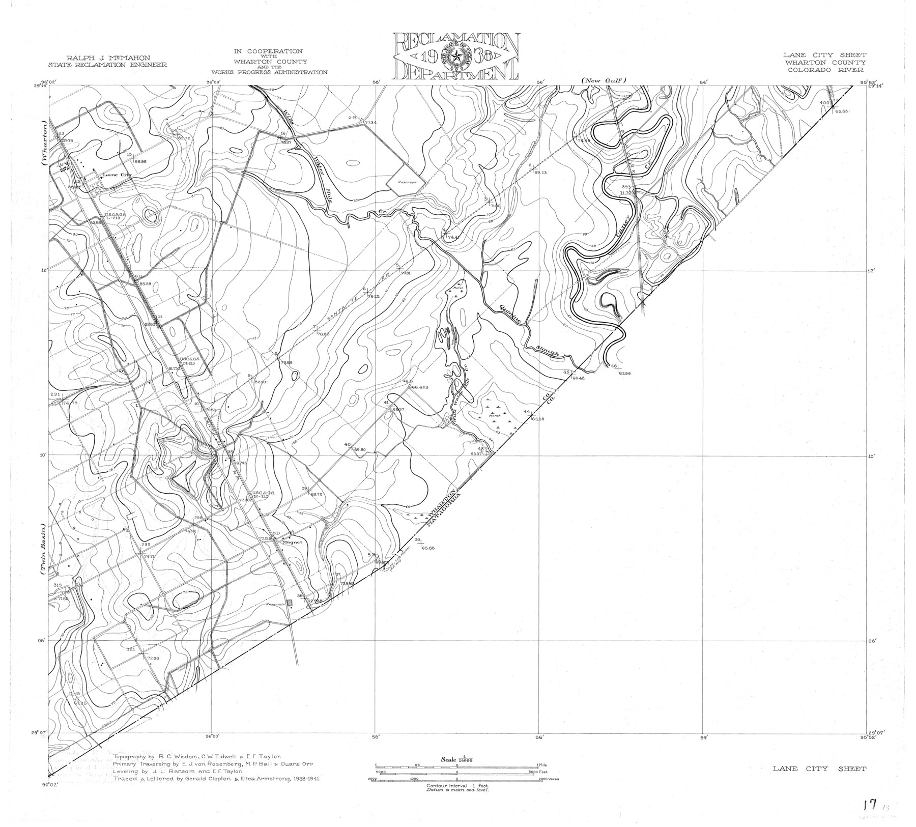
Colorado River, Lane City Sheet
-
Map/Doc
65316
-
Collection
General Map Collection
-
Object Dates
1941 (Creation Date)
-
People and Organizations
Texas State Reclamation Department (Publisher)
Gerald Clopton (Compiler)
Eltea Armstrong (Draftsman)
Gerald Clapton (Draftsman)
Eltea Armstrong (Compiler)
Duane Orr (Surveyor/Engineer)
E.F. Taylor (Surveyor/Engineer)
J.L. Ransom (Surveyor/Engineer)
M.P. Ball (Surveyor/Engineer)
R.C. Wisdom (Surveyor/Engineer)
-
Counties
Wharton
-
Subjects
River Surveys Topographic
-
Height x Width
27.0 x 29.9 inches
68.6 x 75.9 cm
-
Comments
Lane City Sheet located east of the Wharton and Twin Basin Sheets and south of the New Gulf Sheet.
Part of: General Map Collection
Concho County Working Sketch 7

Print $20.00
- Digital $50.00
Concho County Working Sketch 7
1948
Size 44.3 x 46.0 inches
Map/Doc 68189
Aransas County Rolled Sketch 31

Print $20.00
- Digital $50.00
Aransas County Rolled Sketch 31
1986
Size 30.0 x 41.4 inches
Map/Doc 77498
Harris County Working Sketch 26

Print $20.00
- Digital $50.00
Harris County Working Sketch 26
1930
Size 23.9 x 27.2 inches
Map/Doc 65918
El Paso County Working Sketch 13

Print $20.00
- Digital $50.00
El Paso County Working Sketch 13
1956
Size 33.4 x 39.7 inches
Map/Doc 69035
Galveston County Sketch File 15

Print $4.00
- Digital $50.00
Galveston County Sketch File 15
Size 6.7 x 3.7 inches
Map/Doc 23382
Jack County Sketch File 24

Print $4.00
- Digital $50.00
Jack County Sketch File 24
1880
Size 8.3 x 9.5 inches
Map/Doc 27561
Right of Way and Track Map, Dayton-Goose Creek Ry. Co., Station 401+20 to Station 612+40

Print $40.00
- Digital $50.00
Right of Way and Track Map, Dayton-Goose Creek Ry. Co., Station 401+20 to Station 612+40
1917
Size 25.4 x 56.4 inches
Map/Doc 64367

United States and Additions, 1820

Print $20.00
- Digital $50.00
United States and Additions, 1820
1820
Size 21.8 x 27.0 inches
Map/Doc 93798
Titus County Working Sketch 2

Print $20.00
- Digital $50.00
Titus County Working Sketch 2
Size 23.6 x 25.3 inches
Map/Doc 69363
State of Texas

Print $40.00
- Digital $50.00
State of Texas
1965
Size 43.1 x 52.8 inches
Map/Doc 2488
Jones County Sketch File 11a

Print $40.00
- Digital $50.00
Jones County Sketch File 11a
Size 37.5 x 49.5 inches
Map/Doc 10510
You may also like
[Surveys in Chambers County]
![249, [Surveys in Chambers County], General Map Collection](https://historictexasmaps.com/wmedia_w700/maps/249.tif.jpg)
Print $2.00
- Digital $50.00
[Surveys in Chambers County]
1847
Size 7.8 x 5.0 inches
Map/Doc 249
Parmer County Sketch File 1

Print $28.00
- Digital $50.00
Parmer County Sketch File 1
1902
Size 10.6 x 8.2 inches
Map/Doc 33621

Madison County Working Sketch 8

Print $20.00
- Digital $50.00
Madison County Working Sketch 8
1982
Size 22.4 x 28.8 inches
Map/Doc 70770
Ward County Boundary File 2

Print $4.00
- Digital $50.00
Ward County Boundary File 2
Size 11.1 x 8.9 inches
Map/Doc 59673
Wood County Working Sketch Graphic Index

Print $20.00
- Digital $50.00
Wood County Working Sketch Graphic Index
1942
Size 40.6 x 36.4 inches
Map/Doc 76746
San Benito, Texas in the Lower Rio Grande Valley [Frisco Lines]
![95795, San Benito, Texas in the Lower Rio Grande Valley [Frisco Lines], Cobb Digital Map Collection](https://historictexasmaps.com/wmedia_w700/maps/95795.tif.jpg)
Print $20.00
- Digital $50.00
San Benito, Texas in the Lower Rio Grande Valley [Frisco Lines]
1910
Size 19.5 x 19.4 inches
Map/Doc 95795
Lubbock County

Print $20.00
- Digital $50.00
Lubbock County
1968
Size 44.2 x 35.8 inches
Map/Doc 95576
General Highway Map, DeWitt County, Texas

Print $20.00
General Highway Map, DeWitt County, Texas
1961
Size 18.3 x 24.5 inches
Map/Doc 79442
Brazoria County Sketch File 2

Print $6.00
- Digital $50.00
Brazoria County Sketch File 2
Size 8.0 x 3.3 inches
Map/Doc 14920
Crockett County Sketch File 4

Print $6.00
- Digital $50.00
Crockett County Sketch File 4
Size 6.4 x 5.2 inches
Map/Doc 19649
Map of New York and Adjacent Cities

Print $20.00
- Digital $50.00
Map of New York and Adjacent Cities
1860
Size 17.8 x 28.7 inches
Map/Doc 94439