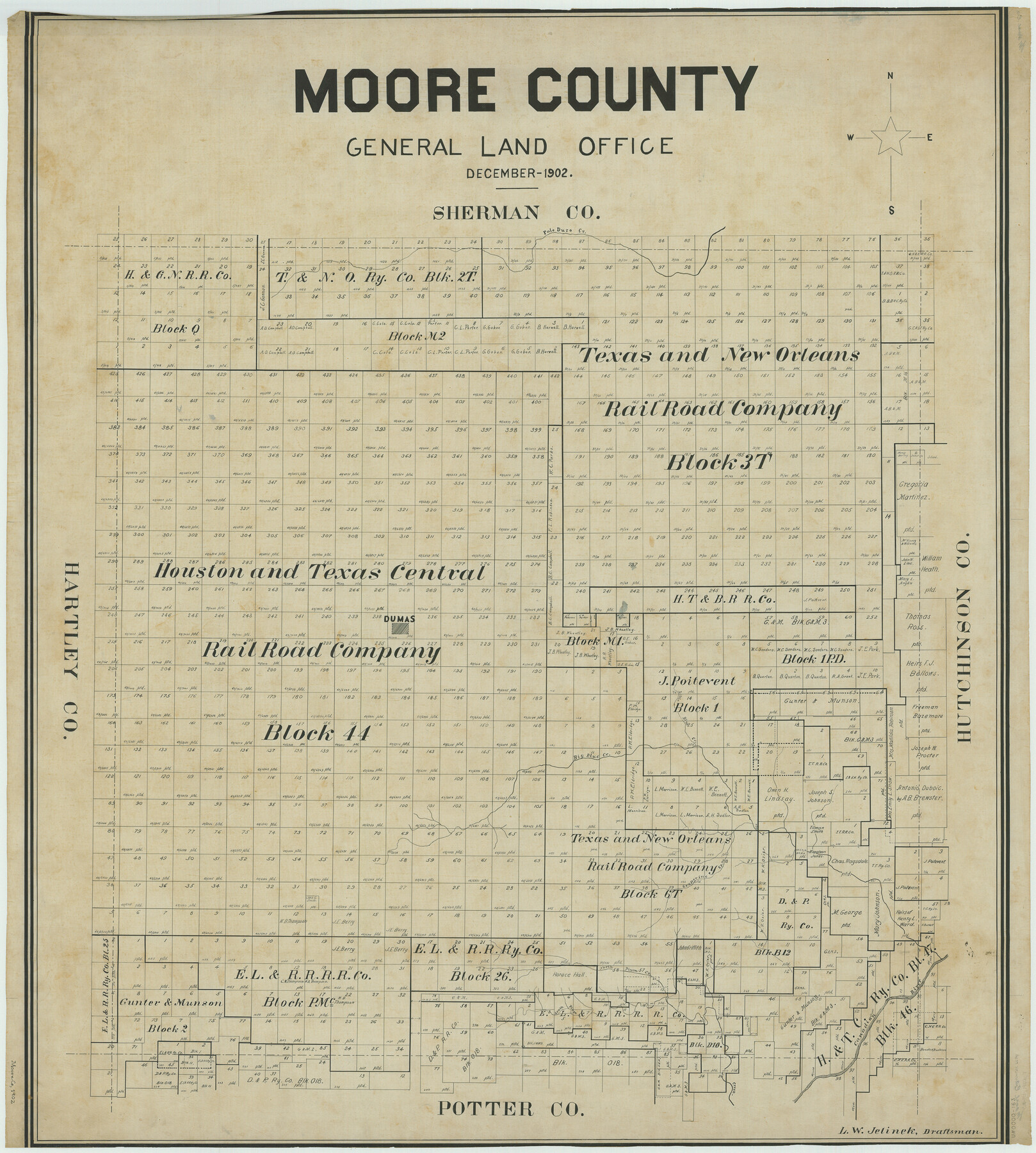
Moore County
-
Map/Doc
66941
-
Collection
General Map Collection
-
Object Dates
1902 (Creation Date)
-
People and Organizations
Texas General Land Office (Publisher)
L.W. Jelinek (Compiler)
L.W. Jelinek (Draftsman)
-
Counties
Moore
-
Subjects
County
-
Height x Width
41.1 x 37.0 inches
104.4 x 94.0 cm
Part of: General Map Collection
Flight Mission No. CGI-3N, Frame 42, Cameron County

Print $20.00
- Digital $50.00
Flight Mission No. CGI-3N, Frame 42, Cameron County
1954
Size 18.5 x 22.1 inches
Map/Doc 84548
Hunt County Working Sketch 10

Print $20.00
- Digital $50.00
Hunt County Working Sketch 10
1959
Size 31.5 x 42.8 inches
Map/Doc 66357
Maverick County Sketch File 14

Print $4.00
- Digital $50.00
Maverick County Sketch File 14
1883
Size 11.1 x 8.5 inches
Map/Doc 31111
Collin County Sketch File 3

Print $20.00
- Digital $50.00
Collin County Sketch File 3
1852
Size 19.5 x 21.4 inches
Map/Doc 11126
Hood County Working Sketch 9

Print $20.00
- Digital $50.00
Hood County Working Sketch 9
1972
Size 28.0 x 31.7 inches
Map/Doc 66203
Nacogdoches County Sketch File 20

Print $26.00
- Digital $50.00
Nacogdoches County Sketch File 20
Size 12.6 x 7.9 inches
Map/Doc 32275
Culberson County Rolled Sketch 53

Print $20.00
- Digital $50.00
Culberson County Rolled Sketch 53
1968
Size 36.7 x 47.2 inches
Map/Doc 8756
Brazoria County Sketch File 24

Print $6.00
- Digital $50.00
Brazoria County Sketch File 24
1868
Size 11.3 x 10.4 inches
Map/Doc 15022
Andrews County Sketch File 9

Print $8.00
- Digital $50.00
Andrews County Sketch File 9
1949
Size 14.2 x 8.6 inches
Map/Doc 12853
Wise County Working Sketch 20

Print $20.00
- Digital $50.00
Wise County Working Sketch 20
1979
Size 22.8 x 27.3 inches
Map/Doc 72634
Trinity County Working Sketch 23

Print $20.00
- Digital $50.00
Trinity County Working Sketch 23
2010
Size 23.4 x 33.6 inches
Map/Doc 89259
Presidio County Rolled Sketch S1

Print $20.00
- Digital $50.00
Presidio County Rolled Sketch S1
Size 13.3 x 18.8 inches
Map/Doc 7414
You may also like
Map Showing Lands Surveyed by Sylvan Sanders, Block D

Print $20.00
- Digital $50.00
Map Showing Lands Surveyed by Sylvan Sanders, Block D
Size 28.2 x 23.5 inches
Map/Doc 92440
[East Portion of Lea County] / [Central part of San Miguel County, New Mexico]
![92033, [East Portion of Lea County] / [Central part of San Miguel County, New Mexico], Twichell Survey Records](https://historictexasmaps.com/wmedia_w700/maps/92033-1.tif.jpg)
Print $20.00
- Digital $50.00
[East Portion of Lea County] / [Central part of San Miguel County, New Mexico]
Size 26.9 x 13.9 inches
Map/Doc 92033
Gregg County Rolled Sketch RGA

Print $46.00
- Digital $50.00
Gregg County Rolled Sketch RGA
1933
Size 34.3 x 30.6 inches
Map/Doc 9026
Flight Mission No. BRA-8M, Frame 130, Jefferson County

Print $20.00
- Digital $50.00
Flight Mission No. BRA-8M, Frame 130, Jefferson County
1953
Size 15.8 x 15.7 inches
Map/Doc 85626
Hudspeth County Sketch File 51

Print $4.00
- Digital $50.00
Hudspeth County Sketch File 51
1962
Size 14.4 x 9.1 inches
Map/Doc 27074
Jim Wells County Working Sketch 10

Print $20.00
- Digital $50.00
Jim Wells County Working Sketch 10
1952
Size 18.7 x 17.8 inches
Map/Doc 66608
Archer County Boundary File 2

Print $92.00
- Digital $50.00
Archer County Boundary File 2
Size 14.4 x 8.4 inches
Map/Doc 50086
Topographical Map of the Rio Grande, Sheet No. 19

Print $20.00
- Digital $50.00
Topographical Map of the Rio Grande, Sheet No. 19
1912
Map/Doc 89543
El Paso County Rolled Sketch 46

Print $20.00
- Digital $50.00
El Paso County Rolled Sketch 46
1937
Size 38.6 x 30.3 inches
Map/Doc 5832
Copy of Surveyor's Field Book, Morris Browning - In Blocks 7, 5 & 4, I&GNRRCo., Hutchinson and Carson Counties, Texas

Print $2.00
- Digital $50.00
Copy of Surveyor's Field Book, Morris Browning - In Blocks 7, 5 & 4, I&GNRRCo., Hutchinson and Carson Counties, Texas
1888
Size 7.0 x 8.8 inches
Map/Doc 62270

