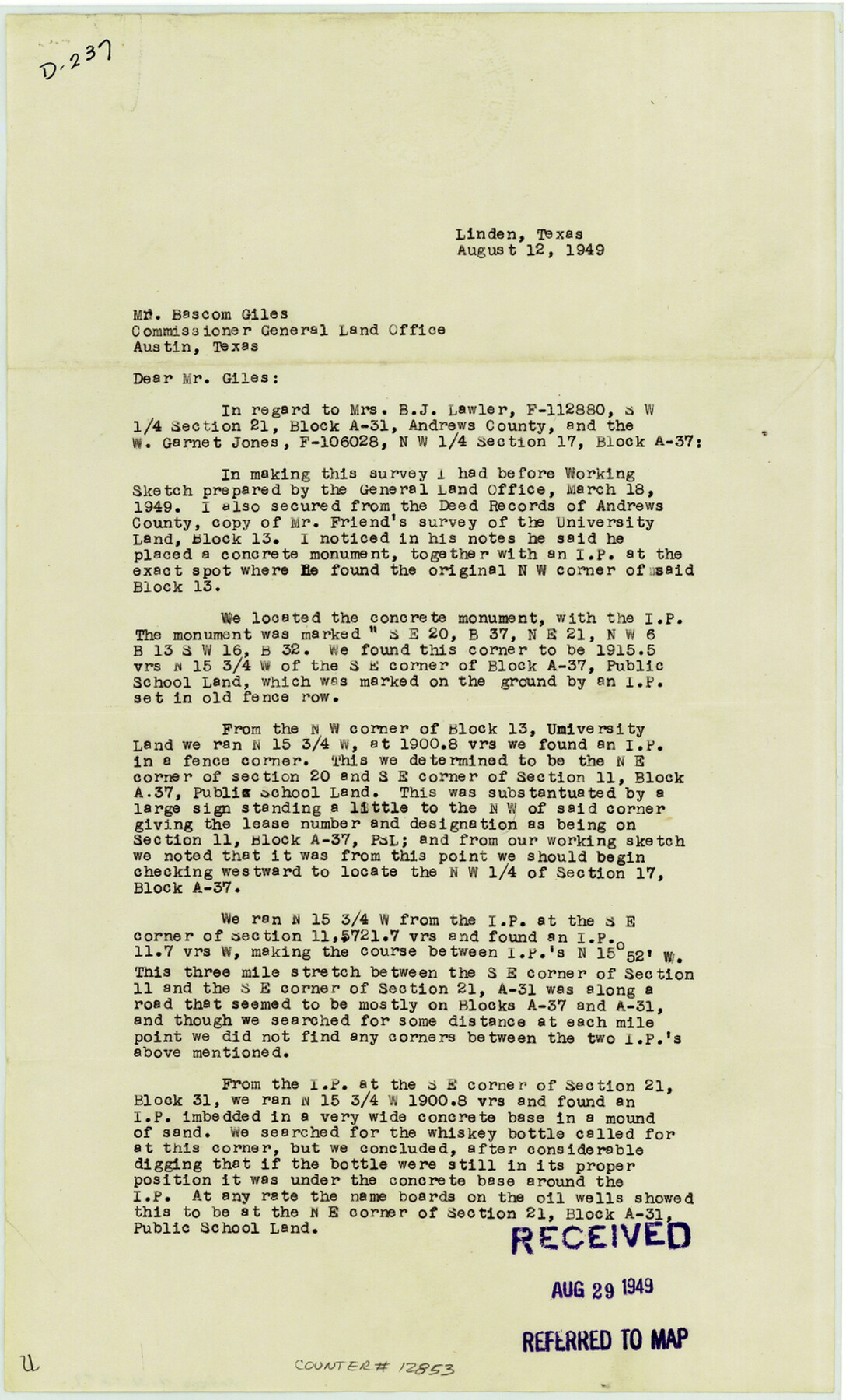
Andrews County Sketch File 9
[Surveyor's report of a resurvey of PSL Block A-37]
-
Map/Doc
12853
-
Collection
General Map Collection
-
Object Dates
1949/8/12 (Creation Date)
1949/8/30 (File Date)
-
People and Organizations
R.B. Smitherman (Surveyor/Engineer)
-
Counties
Andrews
-
Subjects
Surveying Sketch File
-
Height x Width
14.2 x 8.6 inches
36.1 x 21.8 cm
-
Medium
paper, print
-
Comments
See Andrews County Rolled Sketch 29 (77173) for sketch
Related maps
Andrews County Rolled Sketch 29

Print $20.00
- Digital $50.00
Andrews County Rolled Sketch 29
1949
Size 36.6 x 16.3 inches
Map/Doc 77173
Part of: General Map Collection
Cooke County Working Sketch 20

Print $20.00
- Digital $50.00
Cooke County Working Sketch 20
1956
Size 21.1 x 10.4 inches
Map/Doc 68257
Winkler County Rolled Sketch 4

Print $40.00
- Digital $50.00
Winkler County Rolled Sketch 4
1927
Size 59.1 x 39.5 inches
Map/Doc 10147
Rusk County Working Sketch 13

Print $20.00
- Digital $50.00
Rusk County Working Sketch 13
1976
Size 33.2 x 39.1 inches
Map/Doc 63648
Val Verde County Working Sketch 77

Print $20.00
- Digital $50.00
Val Verde County Working Sketch 77
1972
Size 45.9 x 38.5 inches
Map/Doc 72212
[Surveys in Austin's Colony along the east bank of Mill Creek]
![216, [Surveys in Austin's Colony along the east bank of Mill Creek], General Map Collection](https://historictexasmaps.com/wmedia_w700/maps/216.tif.jpg)
Print $3.00
- Digital $50.00
[Surveys in Austin's Colony along the east bank of Mill Creek]
1827
Size 14.4 x 11.1 inches
Map/Doc 216
Jones County Working Sketch 8

Print $20.00
- Digital $50.00
Jones County Working Sketch 8
1979
Size 25.3 x 20.9 inches
Map/Doc 66646
Chambers County Working Sketch 11

Print $20.00
- Digital $50.00
Chambers County Working Sketch 11
1952
Size 40.6 x 26.7 inches
Map/Doc 67994
Palo Pinto County Sketch File 6

Print $40.00
- Digital $50.00
Palo Pinto County Sketch File 6
1875
Size 9.3 x 18.8 inches
Map/Doc 33396
Live Oak County Sketch File 33

Print $4.00
- Digital $50.00
Live Oak County Sketch File 33
1874
Size 11.9 x 7.6 inches
Map/Doc 30333
University Land Field Notes for Blocks 1, 2, 8, 9, and 10 in Reagan County, Blocks 6 and 7 in Crockett and Reagan Counties, Blocks 3, 4, and 58 in Reagan and Upton Counties, and Block 5 in Crockett, Reagan, and Upton Counties

University Land Field Notes for Blocks 1, 2, 8, 9, and 10 in Reagan County, Blocks 6 and 7 in Crockett and Reagan Counties, Blocks 3, 4, and 58 in Reagan and Upton Counties, and Block 5 in Crockett, Reagan, and Upton Counties
Map/Doc 81716
Pecos County Sketch File 21

Print $20.00
- Digital $50.00
Pecos County Sketch File 21
1886
Size 21.6 x 18.5 inches
Map/Doc 12161
Galveston County NRC Article 33.136 Location Key Sheet

Print $20.00
- Digital $50.00
Galveston County NRC Article 33.136 Location Key Sheet
1995
Size 27.0 x 22.0 inches
Map/Doc 83001
You may also like
Randall County Boundary File 5

Print $14.00
- Digital $50.00
Randall County Boundary File 5
Size 8.9 x 7.8 inches
Map/Doc 58134
[Parts of PSL Blocks B18, B19, B28, B20 and B29]
![91952, [Parts of PSL Blocks B18, B19, B28, B20 and B29], Twichell Survey Records](https://historictexasmaps.com/wmedia_w700/maps/91952-1.tif.jpg)
Print $20.00
- Digital $50.00
[Parts of PSL Blocks B18, B19, B28, B20 and B29]
Size 21.4 x 28.0 inches
Map/Doc 91952
Flight Mission No. DQO-3K, Frame 32, Galveston County

Print $20.00
- Digital $50.00
Flight Mission No. DQO-3K, Frame 32, Galveston County
1952
Size 18.7 x 22.5 inches
Map/Doc 85073
Bandera County Sketch File 28

Print $40.00
- Digital $50.00
Bandera County Sketch File 28
Size 23.5 x 20.0 inches
Map/Doc 10897
Calcasieu Pass to Sabine Pass

Print $20.00
- Digital $50.00
Calcasieu Pass to Sabine Pass
1943
Size 44.5 x 35.1 inches
Map/Doc 69805
Irion County Rolled Sketch 18C

Print $40.00
- Digital $50.00
Irion County Rolled Sketch 18C
Size 84.7 x 45.5 inches
Map/Doc 9254
Oldham County Sketch File 9

Print $20.00
- Digital $50.00
Oldham County Sketch File 9
1886
Size 18.4 x 26.1 inches
Map/Doc 12112
The Republic County of Nacogdoches. January 16, 1843

Print $20.00
The Republic County of Nacogdoches. January 16, 1843
2020
Size 15.9 x 21.8 inches
Map/Doc 96249
Flight Mission No. BRA-16M, Frame 65, Jefferson County

Print $20.00
- Digital $50.00
Flight Mission No. BRA-16M, Frame 65, Jefferson County
1953
Size 18.7 x 22.4 inches
Map/Doc 85682
Hemphill County Working Sketch 24

Print $40.00
- Digital $50.00
Hemphill County Working Sketch 24
1974
Size 48.6 x 37.4 inches
Map/Doc 66119
[Plat showing connecting lines for the purpose of locating 4.3 acres in Caldwell County]
![90220, [Plat showing connecting lines for the purpose of locating 4.3 acres in Caldwell County], Twichell Survey Records](https://historictexasmaps.com/wmedia_w700/maps/90220-1.tif.jpg)
Print $2.00
- Digital $50.00
[Plat showing connecting lines for the purpose of locating 4.3 acres in Caldwell County]
1923
Size 7.4 x 10.2 inches
Map/Doc 90220
Real County Working Sketch 45

Print $20.00
- Digital $50.00
Real County Working Sketch 45
1955
Size 23.1 x 18.5 inches
Map/Doc 71937