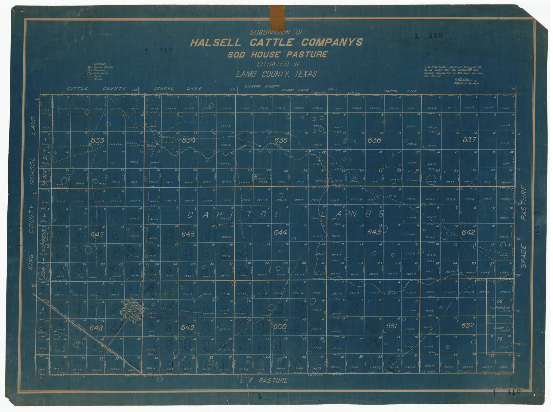
Subdivision of Halsell Cattle Company's Sod House Pasture Situated in Lamb County, Texas
L110
-
Map/Doc
92169
-
Collection
Twichell Survey Records
-
People and Organizations
Sylvan Sanders (Draftsman)
W.J. Williams (Surveyor/Engineer)
-
Counties
Lamb
-
Height x Width
37.3 x 28.2 inches
94.7 x 71.6 cm
Part of: Twichell Survey Records
[K. N. Hapgood's Pasture and surrounding surveys]
![90432, [K. N. Hapgood's Pasture and surrounding surveys], Twichell Survey Records](https://historictexasmaps.com/wmedia_w700/maps/90432-1.tif.jpg)
Print $2.00
- Digital $50.00
[K. N. Hapgood's Pasture and surrounding surveys]
1923
Size 8.7 x 11.5 inches
Map/Doc 90432
[Block 36, Townships 1 and 2 North]
![91388, [Block 36, Townships 1 and 2 North], Twichell Survey Records](https://historictexasmaps.com/wmedia_w700/maps/91388-1.tif.jpg)
Print $20.00
- Digital $50.00
[Block 36, Townships 1 and 2 North]
Size 16.7 x 35.6 inches
Map/Doc 91388
Brazos River Conservation and Reclamation District Official Boundary Line Survey, Parmer County

Print $20.00
- Digital $50.00
Brazos River Conservation and Reclamation District Official Boundary Line Survey, Parmer County
Size 36.6 x 24.8 inches
Map/Doc 91638
[Kent County Block 4, Sections 33 and 46, Block 97, Sections 771 and 772]
![92192, [Kent County Block 4, Sections 33 and 46, Block 97, Sections 771 and 772], Twichell Survey Records](https://historictexasmaps.com/wmedia_w700/maps/92192-1.tif.jpg)
Print $2.00
- Digital $50.00
[Kent County Block 4, Sections 33 and 46, Block 97, Sections 771 and 772]
1951
Size 8.7 x 15.6 inches
Map/Doc 92192
[H. & T. C. RR. Company, Block 47 and vicinity]
![91156, [H. & T. C. RR. Company, Block 47 and vicinity], Twichell Survey Records](https://historictexasmaps.com/wmedia_w700/maps/91156-1.tif.jpg)
Print $20.00
- Digital $50.00
[H. & T. C. RR. Company, Block 47 and vicinity]
Size 18.2 x 19.3 inches
Map/Doc 91156
[I. & G. N. Block 1, sections 57-70]
![91668, [I. & G. N. Block 1, sections 57-70], Twichell Survey Records](https://historictexasmaps.com/wmedia_w700/maps/91668-1.tif.jpg)
Print $20.00
- Digital $50.00
[I. & G. N. Block 1, sections 57-70]
Size 28.8 x 22.1 inches
Map/Doc 91668

Deaf Smith County

Print $40.00
- Digital $50.00
Deaf Smith County
1922
Size 55.0 x 43.9 inches
Map/Doc 89768
[Blocks D and DD, Yoakum County]
![92004, [Blocks D and DD, Yoakum County], Twichell Survey Records](https://historictexasmaps.com/wmedia_w700/maps/92004-1.tif.jpg)
Print $20.00
- Digital $50.00
[Blocks D and DD, Yoakum County]
Size 24.8 x 19.9 inches
Map/Doc 92004
Levelland, Hockley County, Texas

Print $20.00
- Digital $50.00
Levelland, Hockley County, Texas
1950
Size 13.1 x 14.9 inches
Map/Doc 92241
Cow Bayou Oil Field, Orange County, Texas

Print $20.00
- Digital $50.00
Cow Bayou Oil Field, Orange County, Texas
Size 24.0 x 18.8 inches
Map/Doc 93016
General Highway Map, Concho County, Texas

Print $20.00
- Digital $50.00
General Highway Map, Concho County, Texas
1954
Size 18.7 x 25.8 inches
Map/Doc 92551
You may also like
Orange County Working Sketch 41

Print $20.00
- Digital $50.00
Orange County Working Sketch 41
1979
Size 28.0 x 18.2 inches
Map/Doc 71373
Upton County Sketch File 4

Print $40.00
- Digital $50.00
Upton County Sketch File 4
1886
Size 19.5 x 9.0 inches
Map/Doc 12510
Sectional Map No. 2 of the lands and the line of the Texas & Pacific Ry. Co. in Howard, Martin, Andrews, Midland and Tom Green Counties

Print $20.00
- Digital $50.00
Sectional Map No. 2 of the lands and the line of the Texas & Pacific Ry. Co. in Howard, Martin, Andrews, Midland and Tom Green Counties
1885
Size 19.1 x 23.2 inches
Map/Doc 4860
Kerr County Sketch File 25

Print $4.00
- Digital $50.00
Kerr County Sketch File 25
1873
Size 10.0 x 8.0 inches
Map/Doc 28905
Palo Pinto County Rolled Sketch 14

Print $20.00
- Digital $50.00
Palo Pinto County Rolled Sketch 14
Size 29.7 x 42.5 inches
Map/Doc 7194
Starr County Rolled Sketch 2

Print $40.00
- Digital $50.00
Starr County Rolled Sketch 2
1853
Size 31.7 x 48.5 inches
Map/Doc 9938
Presidio County Sketch File 88

Print $6.00
- Digital $50.00
Presidio County Sketch File 88
Size 14.5 x 8.8 inches
Map/Doc 34751
Falls County Sketch File 4

Print $4.00
- Digital $50.00
Falls County Sketch File 4
1856
Size 10.3 x 8.3 inches
Map/Doc 22335
Terry County Rolled Sketch 8

Print $20.00
- Digital $50.00
Terry County Rolled Sketch 8
Size 31.7 x 22.3 inches
Map/Doc 7982
Sutton County Rolled Sketch 57

Print $40.00
- Digital $50.00
Sutton County Rolled Sketch 57
1958
Size 40.1 x 51.1 inches
Map/Doc 10662
Pecos County Working Sketch Graphic Index - south part

Print $20.00
- Digital $50.00
Pecos County Working Sketch Graphic Index - south part
1976
Size 35.3 x 43.2 inches
Map/Doc 76665
Cottle County Working Sketch 4

Print $20.00
- Digital $50.00
Cottle County Working Sketch 4
1916
Size 34.3 x 31.4 inches
Map/Doc 68314