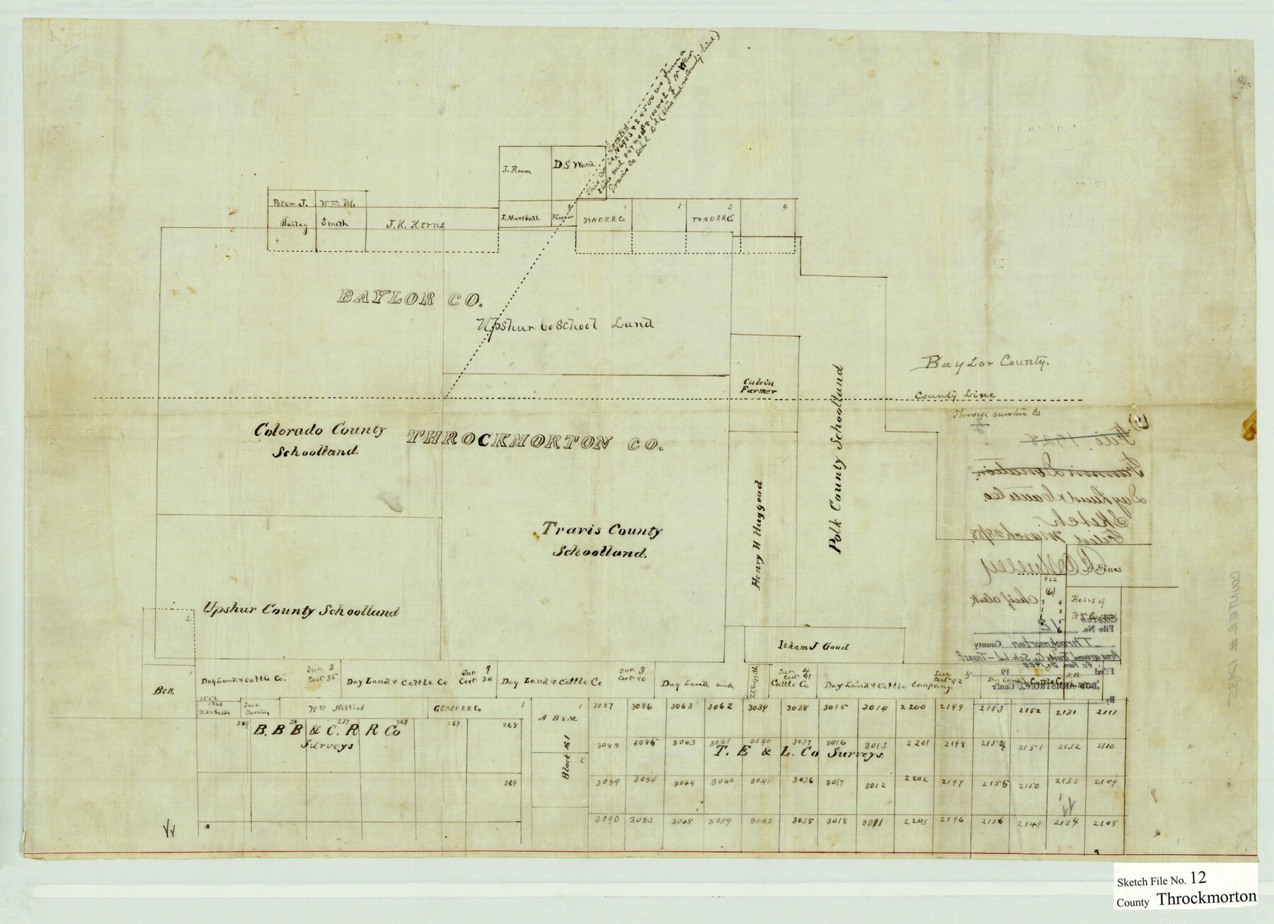
Throckmorton County Sketch File 12
Area Around Travis County School Land, Throckmorton County, Texas
-
Map/Doc
12435
-
Collection
General Map Collection
-
Counties
Throckmorton Baylor
-
Subjects
Surveying Sketch File
-
Height x Width
16.2 x 22.3 inches
41.2 x 56.6 cm
-
Medium
paper, manuscript
Part of: General Map Collection
Colorado County Sketch File 23

Print $4.00
- Digital $50.00
Colorado County Sketch File 23
1882
Size 8.8 x 8.3 inches
Map/Doc 18961
Right of Way and Track Map, Galveston, Harrisburg & San Antonio Ry. operated by the T. & N. O. R.R. Co., Victoria Division, Rosenberg to Beeville

Print $40.00
- Digital $50.00
Right of Way and Track Map, Galveston, Harrisburg & San Antonio Ry. operated by the T. & N. O. R.R. Co., Victoria Division, Rosenberg to Beeville
1918
Size 24.4 x 57.9 inches
Map/Doc 76158
Wood County Working Sketch 8

Print $20.00
- Digital $50.00
Wood County Working Sketch 8
1943
Size 27.7 x 25.2 inches
Map/Doc 62008
Van Zandt County Rolled Sketch 10

Print $20.00
- Digital $50.00
Van Zandt County Rolled Sketch 10
1989
Size 33.7 x 40.6 inches
Map/Doc 10092
Fisher County Sketch File 3

Print $56.00
- Digital $50.00
Fisher County Sketch File 3
1886
Size 8.9 x 5.8 inches
Map/Doc 22549
Young County Sketch File 10c

Print $4.00
- Digital $50.00
Young County Sketch File 10c
1878
Size 8.2 x 15.4 inches
Map/Doc 40872
Red River County Working Sketch 60

Print $20.00
- Digital $50.00
Red River County Working Sketch 60
1973
Size 27.1 x 40.0 inches
Map/Doc 72043
Map of Val Verde County

Print $40.00
- Digital $50.00
Map of Val Verde County
1898
Size 80.7 x 42.7 inches
Map/Doc 16913
Hays County Sketch File 3

Print $4.00
- Digital $50.00
Hays County Sketch File 3
1846
Size 7.1 x 8.2 inches
Map/Doc 26202
[Surveys in the Bexar District along Hondo and Seco Creeks]
![314, [Surveys in the Bexar District along Hondo and Seco Creeks], General Map Collection](https://historictexasmaps.com/wmedia_w700/maps/314.tif.jpg)
Print $3.00
- Digital $50.00
[Surveys in the Bexar District along Hondo and Seco Creeks]
1847
Size 9.3 x 9.9 inches
Map/Doc 314
San Jacinto County Working Sketch 37

Print $20.00
- Digital $50.00
San Jacinto County Working Sketch 37
1965
Size 32.7 x 42.6 inches
Map/Doc 63750
Tyler County Sketch File 19a

Print $4.00
- Digital $50.00
Tyler County Sketch File 19a
Size 8.1 x 14.1 inches
Map/Doc 38672
You may also like
Milam County Sketch File 6

Print $4.00
- Digital $50.00
Milam County Sketch File 6
1902
Size 14.2 x 8.6 inches
Map/Doc 31634
[Map of Nacogdoches County]
![10784, [Map of Nacogdoches County], General Map Collection](https://historictexasmaps.com/wmedia_w700/maps/10784-1.tif.jpg)
Print $40.00
- Digital $50.00
[Map of Nacogdoches County]
1840
Size 79.3 x 69.8 inches
Map/Doc 10784
[Location, Fort Worth & Denver Railroad, through Wilbarger County]
![64344, [Location, Fort Worth & Denver Railroad, through Wilbarger County], General Map Collection](https://historictexasmaps.com/wmedia_w700/maps/64344.tif.jpg)
Print $40.00
- Digital $50.00
[Location, Fort Worth & Denver Railroad, through Wilbarger County]
Size 20.8 x 123.5 inches
Map/Doc 64344
Briscoe County Sketch File 2a

Print $4.00
- Digital $50.00
Briscoe County Sketch File 2a
Size 6.2 x 7.1 inches
Map/Doc 16415
Mason County Working Sketch 20

Print $20.00
- Digital $50.00
Mason County Working Sketch 20
1946
Size 34.6 x 43.9 inches
Map/Doc 70856
Map of Cass County

Print $20.00
- Digital $50.00
Map of Cass County
1847
Size 21.3 x 18.4 inches
Map/Doc 3368
Map of Bexar County

Print $40.00
- Digital $50.00
Map of Bexar County
1845
Size 49.0 x 46.5 inches
Map/Doc 87236
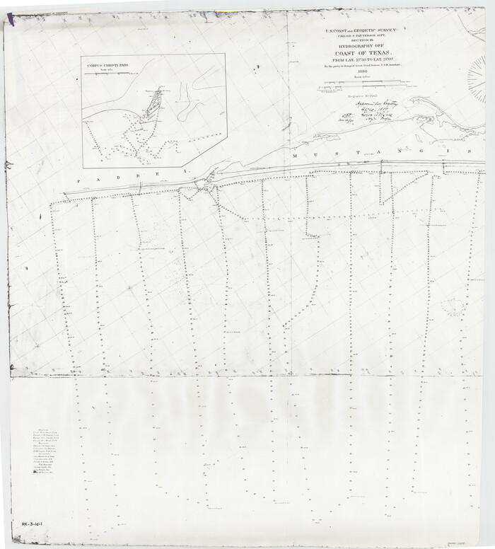
Corpus Christi Pass
Print $20.00
- Digital $50.00
Corpus Christi Pass
1880
Size 45.5 x 41.0 inches
Map/Doc 2694
Colton's New Map of the State of Texas, the Indian Territory and adjoining portions of New Mexico, Louisiana and Arkansas

Print $20.00
- Digital $50.00
Colton's New Map of the State of Texas, the Indian Territory and adjoining portions of New Mexico, Louisiana and Arkansas
1882
Size 32.8 x 37.3 inches
Map/Doc 93909
Bailey County Rolled Sketch 6

Print $20.00
- Digital $50.00
Bailey County Rolled Sketch 6
Size 17.4 x 12.9 inches
Map/Doc 5111
Harrison County Sketch File 23

Print $125.00
- Digital $50.00
Harrison County Sketch File 23
Size 10.6 x 12.2 inches
Map/Doc 26061
Terlingua Special Map, The University of Texas Mineral Survey, Brewster County, Texas

Print $20.00
- Digital $50.00
Terlingua Special Map, The University of Texas Mineral Survey, Brewster County, Texas
1902
Size 20.4 x 22.6 inches
Map/Doc 482