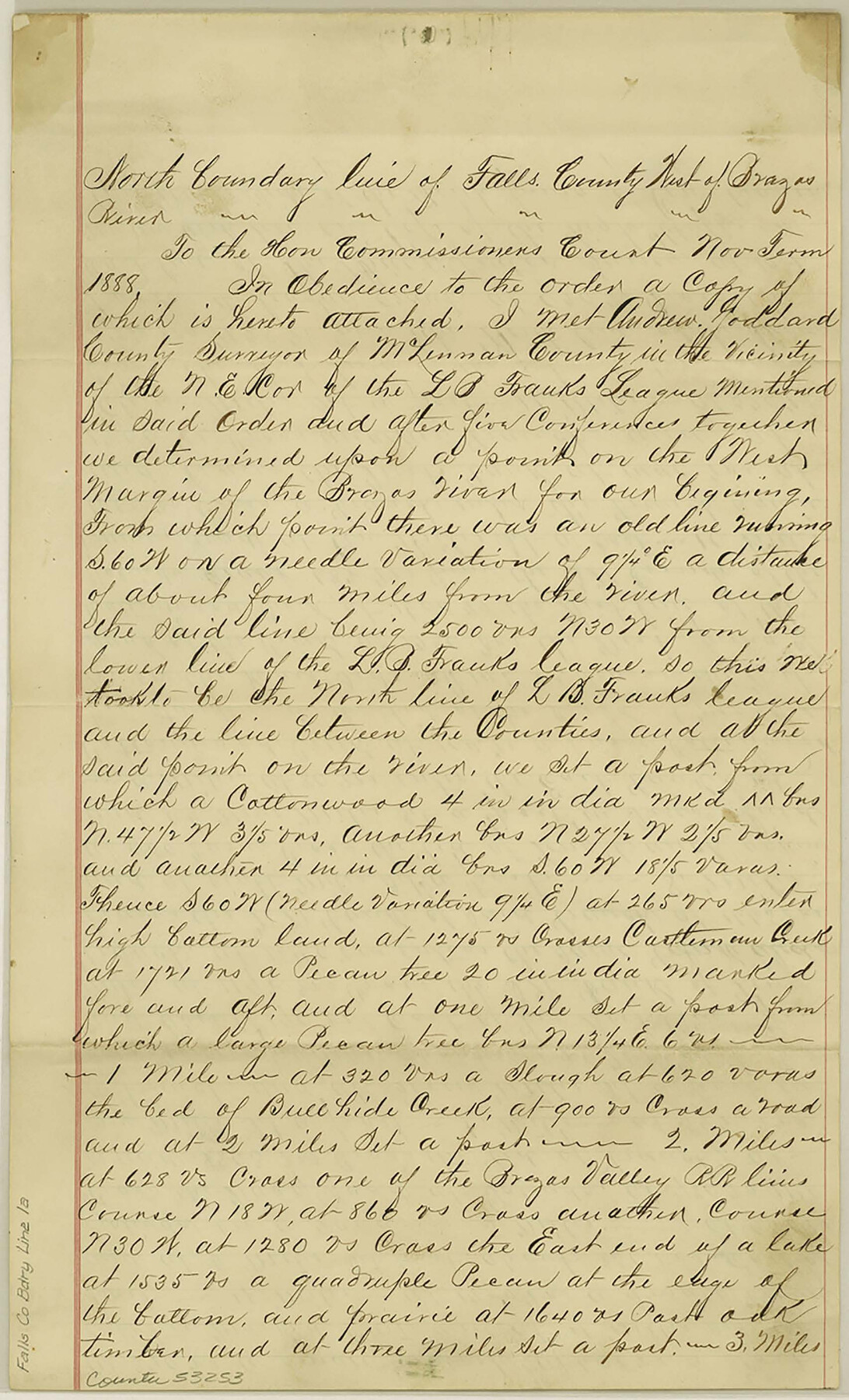
Falls County Boundary File 1a
County line between Falls, Fannin and Grayson Counties
-
Map/Doc
53253
-
Collection
General Map Collection
-
Object Dates
1888/11/12 (Creation Date)
1889/3/3 (File Date)
-
People and Organizations
Robt. S. Hunnicutt (Surveyor/Engineer)
-
Counties
Fannin Grayson Falls
-
Subjects
County Boundaries
-
Height x Width
14.6 x 9.2 inches
37.1 x 23.4 cm
-
Medium
paper, manuscript
Part of: General Map Collection
Map of Robertson County

Print $20.00
- Digital $50.00
Map of Robertson County
1863
Size 25.6 x 20.7 inches
Map/Doc 3997
Sutton County Working Sketch 30

Print $20.00
- Digital $50.00
Sutton County Working Sketch 30
1919
Size 42.6 x 16.9 inches
Map/Doc 62373
Chambers County Sketch File 19

Print $26.00
- Digital $50.00
Chambers County Sketch File 19
Size 14.1 x 8.6 inches
Map/Doc 17578
Flight Mission No. DQN-2K, Frame 3, Calhoun County

Print $20.00
- Digital $50.00
Flight Mission No. DQN-2K, Frame 3, Calhoun County
1953
Size 18.8 x 22.4 inches
Map/Doc 84220
Schleicher County Rolled Sketch 2

Print $20.00
- Digital $50.00
Schleicher County Rolled Sketch 2
1888
Size 25.8 x 32.6 inches
Map/Doc 7746
Map of Chicago, Rock Island & Texas Railway through Wise and Tarrant County, Texas

Print $40.00
- Digital $50.00
Map of Chicago, Rock Island & Texas Railway through Wise and Tarrant County, Texas
1893
Size 19.4 x 121.0 inches
Map/Doc 64428
Dickens County Sketch File E

Print $8.00
- Digital $50.00
Dickens County Sketch File E
Size 11.3 x 8.7 inches
Map/Doc 20843
Anderson County Rolled Sketch 7

Print $20.00
- Digital $50.00
Anderson County Rolled Sketch 7
1941
Size 42.2 x 44.9 inches
Map/Doc 8364
Burnet County Rolled Sketch 2

Print $20.00
- Digital $50.00
Burnet County Rolled Sketch 2
1948
Size 15.5 x 30.5 inches
Map/Doc 5354
Coke County Sketch File 14

Print $6.00
- Digital $50.00
Coke County Sketch File 14
1891
Size 10.8 x 13.1 inches
Map/Doc 18598
Flight Mission No. DIX-3P, Frame 135, Aransas County

Print $20.00
- Digital $50.00
Flight Mission No. DIX-3P, Frame 135, Aransas County
1956
Size 17.8 x 18.5 inches
Map/Doc 83765
Gray County Boundary File 11

Print $80.00
- Digital $50.00
Gray County Boundary File 11
Size 20.7 x 19.7 inches
Map/Doc 53912
You may also like
Bexar County Sketch File 21

Print $4.00
- Digital $50.00
Bexar County Sketch File 21
1859
Size 12.2 x 7.9 inches
Map/Doc 14484
Concho County Rolled Sketch 4

Print $20.00
- Digital $50.00
Concho County Rolled Sketch 4
1948
Size 47.3 x 43.6 inches
Map/Doc 8649
Map of Wharton County

Print $20.00
- Digital $50.00
Map of Wharton County
1878
Size 22.4 x 29.9 inches
Map/Doc 4134
Grayson County Working Sketch 6

Print $20.00
- Digital $50.00
Grayson County Working Sketch 6
1940
Size 28.6 x 40.5 inches
Map/Doc 63245
Flight Mission No. DAG-17K, Frame 76, Matagorda County

Print $20.00
- Digital $50.00
Flight Mission No. DAG-17K, Frame 76, Matagorda County
1952
Size 16.6 x 16.6 inches
Map/Doc 86335
City of Austin, Texas and Suburban Territory

Print $40.00
- Digital $50.00
City of Austin, Texas and Suburban Territory
1952
Size 47.8 x 53.0 inches
Map/Doc 73583
Henderson County Working Sketch 9

Print $20.00
- Digital $50.00
Henderson County Working Sketch 9
1921
Size 30.9 x 16.7 inches
Map/Doc 66142
Red River County Working Sketch 39

Print $20.00
- Digital $50.00
Red River County Working Sketch 39
1967
Size 33.4 x 23.8 inches
Map/Doc 72022
Flight Mission No. DQN-1K, Frame 112, Calhoun County

Print $20.00
- Digital $50.00
Flight Mission No. DQN-1K, Frame 112, Calhoun County
1953
Size 18.6 x 22.3 inches
Map/Doc 84179
Sunset, Montague Co., Texas

Print $20.00
Sunset, Montague Co., Texas
1890
Size 9.7 x 14.5 inches
Map/Doc 89209
Ochiltree County School Land League Number 204

Print $20.00
- Digital $50.00
Ochiltree County School Land League Number 204
1926
Size 20.8 x 13.7 inches
Map/Doc 92473
Crockett County Working Sketch Graphic Index - northwest part - sheet A

Print $40.00
- Digital $50.00
Crockett County Working Sketch Graphic Index - northwest part - sheet A
1983
Size 37.0 x 48.2 inches
Map/Doc 76509