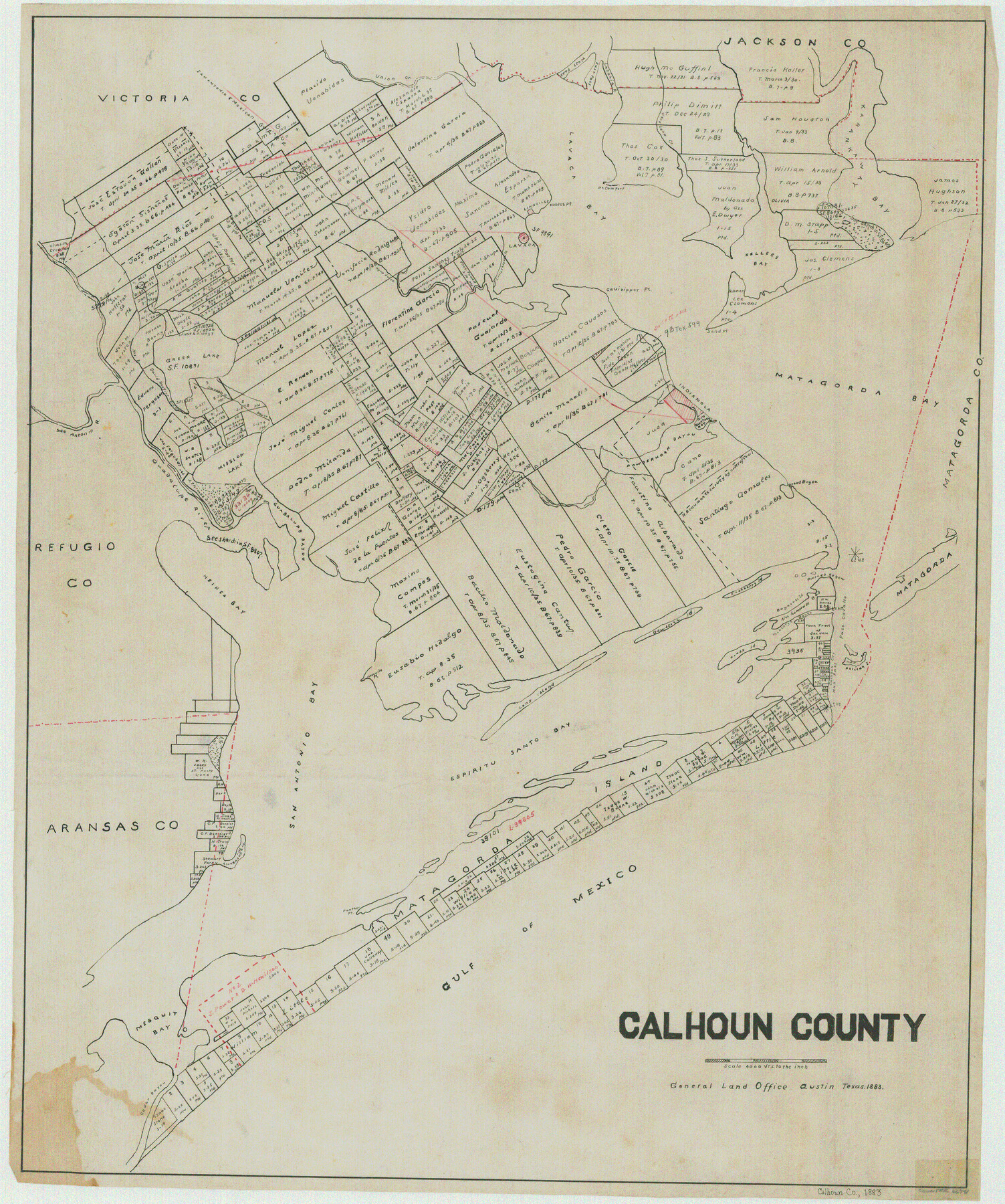
Calhoun County
-
Map/Doc
66741
-
Collection
General Map Collection
-
Object Dates
1883 (Creation Date)
-
People and Organizations
Texas General Land Office (Publisher)
-
Counties
Calhoun
-
Subjects
County
-
Height x Width
22.9 x 19.1 inches
58.2 x 48.5 cm
Part of: General Map Collection
Motley County Sketch File B3 (N)

Print $10.00
- Digital $50.00
Motley County Sketch File B3 (N)
1900
Size 6.5 x 11.9 inches
Map/Doc 31974
Collin County Boundary File 4 and 4a

Print $160.00
- Digital $50.00
Collin County Boundary File 4 and 4a
Size 11.9 x 8.5 inches
Map/Doc 51691
San Saba County Sketch File 11

Print $8.00
- Digital $50.00
San Saba County Sketch File 11
1882
Size 12.4 x 8.3 inches
Map/Doc 36435
Colorado County Working Sketch 20

Print $20.00
- Digital $50.00
Colorado County Working Sketch 20
1963
Size 27.9 x 24.7 inches
Map/Doc 68120
Culberson County Rolled Sketch 54

Print $40.00
- Digital $50.00
Culberson County Rolled Sketch 54
1968
Size 59.0 x 29.4 inches
Map/Doc 10300
Van Zandt County

Print $20.00
- Digital $50.00
Van Zandt County
1870
Size 22.9 x 21.6 inches
Map/Doc 4637
Zavala County Sketch File 35

Print $4.00
- Digital $50.00
Zavala County Sketch File 35
1887
Size 11.3 x 9.0 inches
Map/Doc 41397
Childress County Sketch File 18a

Print $4.00
- Digital $50.00
Childress County Sketch File 18a
1935
Size 11.3 x 7.1 inches
Map/Doc 18364
Duval County Rolled Sketch 34

Print $20.00
- Digital $50.00
Duval County Rolled Sketch 34
1951
Size 24.3 x 37.6 inches
Map/Doc 5749
Fractional Township No. 9 South Range No. 1 East of the Indian Meridian, Indian Territory

Print $20.00
- Digital $50.00
Fractional Township No. 9 South Range No. 1 East of the Indian Meridian, Indian Territory
1898
Size 19.2 x 24.4 inches
Map/Doc 75201
Flight Mission No. CRC-3R, Frame 211, Chambers County

Print $20.00
- Digital $50.00
Flight Mission No. CRC-3R, Frame 211, Chambers County
1956
Size 18.6 x 22.2 inches
Map/Doc 84866
Nueces County Rolled Sketch 92

Print $222.00
Nueces County Rolled Sketch 92
1983
Size 24.6 x 43.7 inches
Map/Doc 7028
You may also like
North Line of Lynn County and South Line of Lubbock County

Print $20.00
- Digital $50.00
North Line of Lynn County and South Line of Lubbock County
1892
Size 8.0 x 34.2 inches
Map/Doc 91393
McCulloch County Sketch File 14

Print $8.00
- Digital $50.00
McCulloch County Sketch File 14
1990
Size 11.2 x 8.7 inches
Map/Doc 31203
Clay County Sketch File 26

Print $84.00
- Digital $50.00
Clay County Sketch File 26
1888
Size 14.3 x 9.0 inches
Map/Doc 18442
Map of Padre Island Showing Location of Zoning Districts

Print $20.00
- Digital $50.00
Map of Padre Island Showing Location of Zoning Districts
1971
Size 18.8 x 26.7 inches
Map/Doc 4809
McCulloch County Working Sketch 1

Print $20.00
- Digital $50.00
McCulloch County Working Sketch 1
1944
Size 29.8 x 29.9 inches
Map/Doc 70676
[Townships 1 & 2, Blocks 56, 57]
![92927, [Townships 1 & 2, Blocks 56, 57], Twichell Survey Records](https://historictexasmaps.com/wmedia_w700/maps/92927-1.tif.jpg)
Print $20.00
- Digital $50.00
[Townships 1 & 2, Blocks 56, 57]
Size 19.7 x 22.8 inches
Map/Doc 92927
General Highway Map, Williamson County, Texas

Print $20.00
General Highway Map, Williamson County, Texas
1940
Size 24.7 x 18.4 inches
Map/Doc 79281
Topographical Map of the Rio Grande, Sheet No. 16

Print $20.00
- Digital $50.00
Topographical Map of the Rio Grande, Sheet No. 16
1912
Map/Doc 89540
Hardin County Sketch File 19

Print $6.00
- Digital $50.00
Hardin County Sketch File 19
Size 13.0 x 10.9 inches
Map/Doc 25135
Flight Mission No. CGI-3N, Frame 181, Cameron County

Print $20.00
- Digital $50.00
Flight Mission No. CGI-3N, Frame 181, Cameron County
1954
Size 18.5 x 22.2 inches
Map/Doc 84645
International and Great Northern Railroad Lone Star Route and Connections

Print $20.00
- Digital $50.00
International and Great Northern Railroad Lone Star Route and Connections
1877
Size 17.3 x 23.2 inches
Map/Doc 93462
Kendall County Working Sketch 26

Print $20.00
- Digital $50.00
Kendall County Working Sketch 26
1985
Size 42.5 x 36.0 inches
Map/Doc 66698