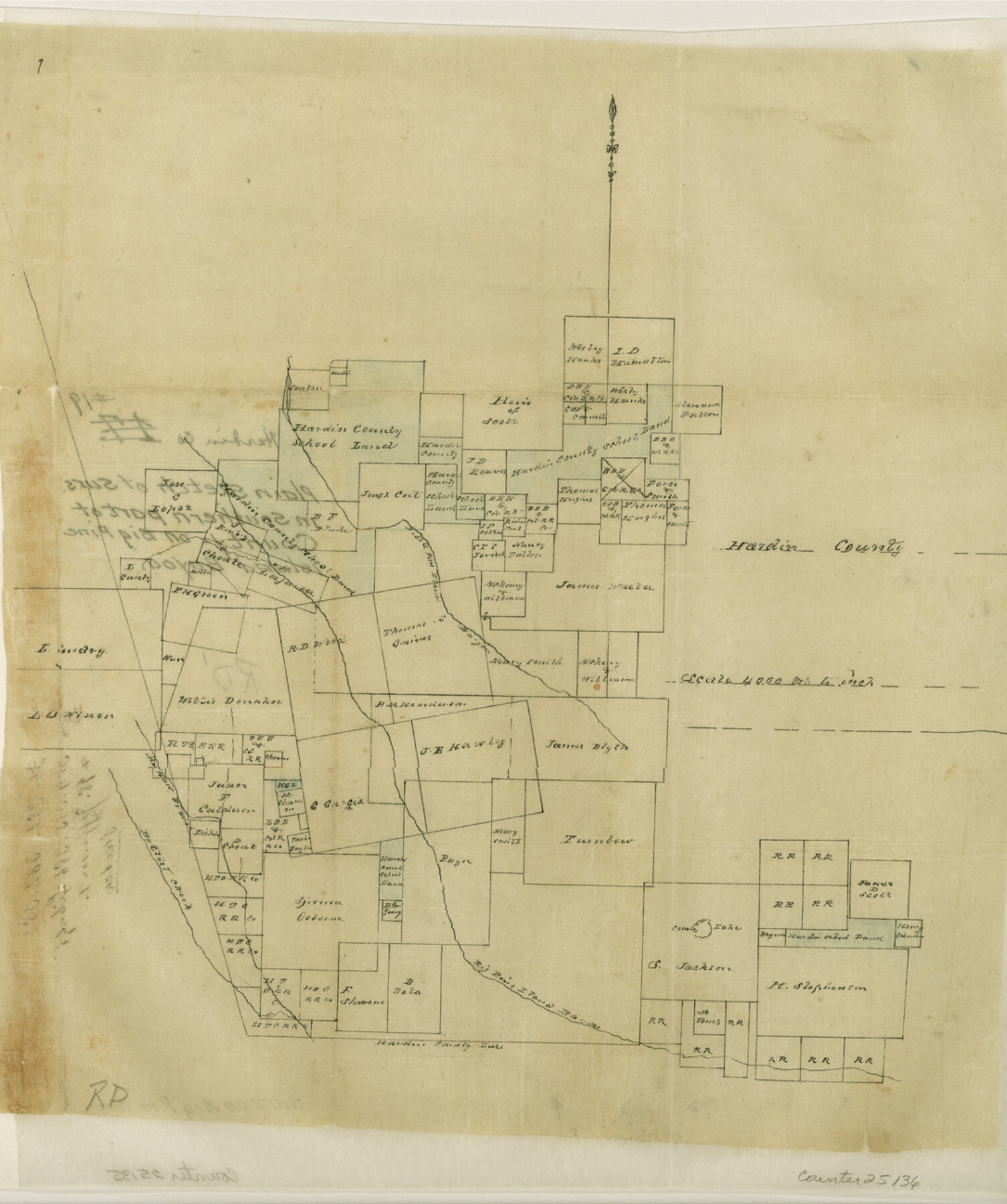
Hardin County Sketch File 19
[Plain sketch of surveys in southern part of county on Big Pine Island Bayou]
-
Map/Doc
25135
-
Collection
General Map Collection
-
Counties
Hardin Liberty Jefferson
-
Subjects
Surveying Sketch File
-
Height x Width
13.0 x 10.9 inches
33.0 x 27.7 cm
-
Medium
paper, manuscript
-
Scale
1" = 4000 varas
-
Features
Little Pine Island Bayou
Big Pine Island Bayuo
Baltest Creek
Zavala Lake
Maj. Moer [?] Branch of Baltest Creek
Part of: General Map Collection
Texas-Oklahoma (Indian Territory) Gainesville Quadrangle

Print $20.00
- Digital $50.00
Texas-Oklahoma (Indian Territory) Gainesville Quadrangle
1902
Size 21.2 x 17.2 inches
Map/Doc 75101
Flight Mission No. DAH-9M, Frame 84, Orange County

Print $20.00
- Digital $50.00
Flight Mission No. DAH-9M, Frame 84, Orange County
1953
Size 18.7 x 22.5 inches
Map/Doc 86848
Harrison County Sketch File 19

Print $20.00
- Digital $50.00
Harrison County Sketch File 19
1954
Size 25.0 x 21.7 inches
Map/Doc 11692
Uvalde County Sketch File 21

Print $8.00
- Digital $50.00
Uvalde County Sketch File 21
1882
Size 14.2 x 8.8 inches
Map/Doc 39004
Palo Pinto County Sketch File 6a

Print $20.00
- Digital $50.00
Palo Pinto County Sketch File 6a
Size 37.8 x 38.6 inches
Map/Doc 10565
Map of Maryland, Virginia, North Carolina and South Carolina

Print $20.00
- Digital $50.00
Map of Maryland, Virginia, North Carolina and South Carolina
1885
Size 12.2 x 9.0 inches
Map/Doc 93517
Sterling County Sketch File 17

Print $8.00
- Digital $50.00
Sterling County Sketch File 17
1936
Size 11.2 x 8.8 inches
Map/Doc 37154
Bandera County Working Sketch 32

Print $20.00
- Digital $50.00
Bandera County Working Sketch 32
1956
Size 22.7 x 18.4 inches
Map/Doc 67628
Flight Mission No. CRC-5R, Frame 24, Chambers County

Print $20.00
- Digital $50.00
Flight Mission No. CRC-5R, Frame 24, Chambers County
1956
Size 18.7 x 22.4 inches
Map/Doc 84946
Upshur County Working Sketch 4

Print $20.00
- Digital $50.00
Upshur County Working Sketch 4
1939
Size 21.6 x 15.3 inches
Map/Doc 69560
Hunt County Working Sketch Graphic Index

Print $40.00
- Digital $50.00
Hunt County Working Sketch Graphic Index
1944
Size 50.5 x 37.0 inches
Map/Doc 76585
Henderson County Sketch File 19

Print $4.00
- Digital $50.00
Henderson County Sketch File 19
Size 9.1 x 8.9 inches
Map/Doc 26363
You may also like
Texas 1972 Official Highway Travel Map

Digital $50.00
Texas 1972 Official Highway Travel Map
Size 27.9 x 36.0 inches
Map/Doc 94313
Fisher County Sketch File 13

Print $20.00
- Digital $50.00
Fisher County Sketch File 13
Size 18.3 x 17.7 inches
Map/Doc 11480
Flight Mission No. CRK-3P, Frame 126, Refugio County

Print $20.00
- Digital $50.00
Flight Mission No. CRK-3P, Frame 126, Refugio County
1956
Size 18.6 x 22.4 inches
Map/Doc 86914
Milam County Working Sketch 10

Print $20.00
- Digital $50.00
Milam County Working Sketch 10
1986
Size 25.5 x 34.6 inches
Map/Doc 71025
Pecos County Rolled Sketch 162

Print $20.00
- Digital $50.00
Pecos County Rolled Sketch 162
Size 47.2 x 21.0 inches
Map/Doc 9741
Edwards County Working Sketch 70

Print $20.00
- Digital $50.00
Edwards County Working Sketch 70
1957
Size 22.5 x 22.4 inches
Map/Doc 68946
Houston County Sketch File 1b

Print $4.00
- Digital $50.00
Houston County Sketch File 1b
1857
Size 8.5 x 7.9 inches
Map/Doc 26744
Flight Mission No. DAH-9M, Frame 206, Orange County

Print $20.00
- Digital $50.00
Flight Mission No. DAH-9M, Frame 206, Orange County
1953
Size 18.7 x 22.7 inches
Map/Doc 86874
Flight Mission No. DQO-7K, Frame 84, Galveston County

Print $20.00
- Digital $50.00
Flight Mission No. DQO-7K, Frame 84, Galveston County
1952
Size 18.8 x 22.5 inches
Map/Doc 85111
Upton County Working Sketch 20

Print $40.00
- Digital $50.00
Upton County Working Sketch 20
1950
Size 52.8 x 42.1 inches
Map/Doc 69516
San Benito, Texas on the Frisco in the Lower Rio Grande Valley

San Benito, Texas on the Frisco in the Lower Rio Grande Valley
1911
Map/Doc 96727
